Property Record
342 Boston Post Rd, Old Saybrook, CT 06475


NEARBY LISTINGS FOR SALE OR LEASE
-
-
View all Old Saybrook listings for sale on LoopNet.com
Property Detail
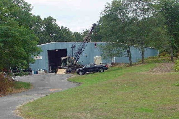
342 Boston Post Rd
OSAY-000053-000047-000003
Middlesex
Commercialbuilding
Connecticut
X
3
09011C0461J
1.12 AC
2025
SW Midlsx/Old Saybrk
2025
Hartford
670200
Hartford-West Hartford-East Hartford, CT
9,600 SF
DEMOGRAPHICS near 342 Boston Post Rd
1 mile
3 mile
5 mile
2024 Total Population
1,751
13,453
29,281
2029 Population
1,767
13,773
29,849
Pop Growth 2024-2029
+ 0.91%
+ 2.38%
+ 1.94%
Average Age
48
50
50
2024 Total Households
740
6,003
13,048
HH Growth 2024-2029
+ 0.95%
+ 2.37%
+ 2.03%
Median Household Inc
$84,400
$108,397
$101,334
Avg Household Size
2.20
2.20
2.20
2024 Avg HH Vehicles
2.00
2.00
2.00
Median Home Value
$432,301
$435,746
$434,103
Median Year Built
1978
1969
1969
Nearby Places
Map Layers
Map Styles
 Street
 Aerial
Transit
 Traffic
 Biking
Places
Listings with unknown addresses are not visible on the map
- Restaurants
- Banks
- Shops
- Fitness
- Groceries
PUBLIC TRANSPORTATION
COMMUTER RAIL
Old Saybrook (Shore Line East - Shore Line East)
Drive
Walk
Distance
Old Saybrook (Shore Line East - Shore Line East)
3 min
1.0 mi
Drive
Walk
Distance
9 min
5.3 mi
AIRPORT
Tweed/New Haven
Drive
Walk
Distance
Tweed/New Haven
42 min
30.0 mi
Freight Ports
Port of New Haven
Drive
Walk
Distance
Port of New Haven
39 min
29.7 mi
SALE & LEASE HISTORY
LISTING DATE
SALE/LEASE

Nov 28, 2021
For Sale
Nov 27, 2021
For Lease
Nearby Properties
Address
Land Use
TOTAL SIZE
Lot Size
Zoning
Address
Land Use
TOTAL SIZE
Lot Size
Zoning
10.78 AC
B-2
Address
Land Use
TOTAL SIZE
Lot Size
Zoning
44.21 AC
RU80
Address
Land Use
TOTAL SIZE
Lot Size
Zoning
35.40 AC
B-2
Address
Land Use
TOTAL SIZE
Lot Size
Zoning
12.34 AC
RU40
Address
Land Use
TOTAL SIZE
Lot Size
Zoning
40,942 SF
7.45 AC
A
Address
Land Use
TOTAL SIZE
Lot Size
Zoning
83,486 SF
3.71 AC
SP-2
Address
Land Use
TOTAL SIZE
Lot Size
Zoning
20.17 AC
A
Address
Land Use
TOTAL SIZE
Lot Size
Zoning
14.78 AC
B-4
Address
Land Use
TOTAL SIZE
Lot Size
Zoning
12.35 AC
C-30
Address
Land Use
TOTAL SIZE
Lot Size
Zoning
101,587 SF
34.34 AC
A
Address
Land Use
TOTAL SIZE
Lot Size
Zoning
10.36 AC
RU40
Address
Land Use
TOTAL SIZE
Lot Size
Zoning
14.25 AC
A
Address
Land Use
TOTAL SIZE
Lot Size
Zoning
8,565 SF
2.08 AC
AA-2
Address
Land Use
TOTAL SIZE
Lot Size
Zoning
8,699 SF
1.52 AC
AA-2
Address
Land Use
TOTAL SIZE
Lot Size
Zoning
80.46 AC
AA-2
Address
Land Use
TOTAL SIZE
Lot Size
Zoning
11,373 SF
0.66 AC
AA-2
Address
Land Use
TOTAL SIZE
Lot Size
Zoning
72,128 SF
22.08 AC
I-1
Address
Land Use
TOTAL SIZE
Lot Size
Zoning
10.80 AC
I-1
Address
Land Use
TOTAL SIZE
Lot Size
Zoning
17,833 SF
3.87 AC
A
Address
Land Use
TOTAL SIZE
Lot Size
Zoning
7.36 AC
B1
Address
Land Use
TOTAL SIZE
Lot Size
Zoning
25,144 SF
3.74 AC
B-4
Address
Land Use
TOTAL SIZE
Lot Size
Zoning
24,360 SF
7.78 AC
B-2
Address
Land Use
TOTAL SIZE
Lot Size
Zoning
11.80 AC
RU40
Address
Land Use
TOTAL SIZE
Lot Size
Zoning
8,054 SF
1.68 AC
AA-2
Address
Land Use
TOTAL SIZE
Lot Size
Zoning
64,427 SF
1.46 AC
Address
Land Use
TOTAL SIZE
Lot Size
Zoning
291,816 SF
29.64 AC
I-1
Address
Land Use
TOTAL SIZE
Lot Size
Zoning
5,470 SF
1.48 AC
AA-2
Address
Land Use
TOTAL SIZE
Lot Size
Zoning
9,244 SF
1.10 AC
AA-2
Address
Land Use
TOTAL SIZE
Lot Size
Zoning
52,960 SF
32 AC
AA1
Address
Land Use
TOTAL SIZE
Lot Size
Zoning
55,250 SF
4.41 AC
B-4
The World's #1 Commercial Real Estate Marketplace
Connect with us
© 2026 CoStar Group
The information above has been obtained from sources believed reliable. While we do not doubt its accuracy we have not verified it and make no guarantee, warranty or representation about it. It is your responsibility to independently confirm its accuracy and completeness. Any projections, opinions, assumptions, or estimates used are for example only and do not represent the current or future performance of the property. The value of this transaction to you depends on tax and other factors which should be evaluated by your tax, financial, and legal advisors. You and your advisors should conduct a careful, independent investigation of the property to determine to your satisfaction the suitability of the property for your needs.