Property Record
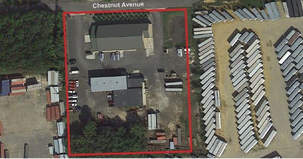
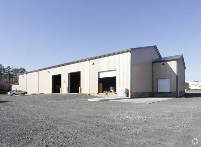
342 Chestnut Ave, West Berlin, NJ 08091


Property Detail
342 Chestnut Ave
06-02103-0000-00013
OFFICE WAREHOUSE
Industrialgeneral
Camden
I1
New Jersey
B and X Area of moderate flood hazard, usually the area between the limits of the 100-year and 500-year floods.
13
2025
3.78 AC
2025
Camden County
608800
Philadelphia
22,129 SF
Philadelphia-Camden-Wilmington, PA-NJ-DE-MD
NEARBY LISTINGS FOR SALE OR LEASE
DEMOGRAPHICS near 342 Chestnut Ave
1 mile
3 mile
5 mile
2025 Total Population
3,792
33,722
95,342
2030 Population
3,895
34,604
97,289
Pop Growth 2025-2030
+ 2.72%
+ 2.62%
+ 2.04%
Average Age
43
42
41
2025 Total Households
1,412
12,514
36,492
HH Growth 2025-2030
+ 2.76%
+ 2.80%
+ 2.13%
Median Household Inc
$112,710
$112,386
$97,293
Avg Household Size
2.70
2.60
2.60
2025 Avg HH Vehicles
2.00
2.00
2.00
Median Home Value
$382,835
$359,952
$343,410
Median Year Built
1973
1978
1978
Nearby Places
Map Layers
Map Styles
 Street
 Aerial
Transit
 Traffic
 Biking
Places
Listings with unknown addresses are not visible on the map
- Restaurants
- Banks
- Shops
- Fitness
- Groceries
PUBLIC TRANSPORTATION
COMMUTER RAIL
Atco (Atlantic City Line - NJ Transit Commuter Rail (NJ Transit))
Drive
Walk
Distance
Atco (Atlantic City Line - NJ Transit Commuter Rail (NJ Transit))
7 min
3.5 mi
Lindenwold (Njt) (Atlantic City Line - NJ Transit Commuter Rail (NJ Transit))
Drive
Walk
Distance
Lindenwold (Njt) (Atlantic City Line - NJ Transit Commuter Rail (NJ Transit))
12 min
6.7 mi
AIRPORT
Philadelphia International
Drive
Walk
Distance
Philadelphia International
42 min
25.4 mi
Atlantic City International
Drive
Walk
Distance
Atlantic City International
66 min
35.1 mi
Freight Ports
Broadway Terminal - Pier 5
Drive
Walk
Distance
Broadway Terminal - Pier 5
26 min
16.9 mi
SALE & LEASE HISTORY
LISTING DATE
SALE/LEASE

Sep 25, 2016
For Lease
Sep 24, 2016
For Sale
Nearby Properties
Address
Land Use
TOTAL SIZE
Lot Size
Zoning
Address
Land Use
TOTAL SIZE
Lot Size
Zoning
6,208 SF
30.73 AC
PARC
Address
Land Use
TOTAL SIZE
Lot Size
Zoning
202,484 SF
19.93 AC
MB
Address
Land Use
TOTAL SIZE
Lot Size
Zoning
44.34 AC
C1
Address
Land Use
TOTAL SIZE
Lot Size
Zoning
4,480 SF
88.36 AC
PR4
Address
Land Use
TOTAL SIZE
Lot Size
Zoning
89,793 SF
5.08 AC
MB
Address
Land Use
TOTAL SIZE
Lot Size
Zoning
27.18 AC
PR4
Address
Land Use
TOTAL SIZE
Lot Size
Zoning
171,540 SF
0.02 AC
MB
Address
Land Use
TOTAL SIZE
Lot Size
Zoning
118,180 SF
2.71 AC
MB
Address
Land Use
TOTAL SIZE
Lot Size
Zoning
16.71 AC
MF
Address
Land Use
TOTAL SIZE
Lot Size
Zoning
14.53 AC
C2
Address
Land Use
TOTAL SIZE
Lot Size
Zoning
4.67 AC
INST
Address
Land Use
TOTAL SIZE
Lot Size
Zoning
61,668 SF
18.72 AC
CP
Address
Land Use
TOTAL SIZE
Lot Size
Zoning
46,018 SF
0.19 AC
MB
Address
Land Use
TOTAL SIZE
Lot Size
Zoning
34.55 AC
INS
Address
Land Use
TOTAL SIZE
Lot Size
Zoning
19.46 AC
INST
Address
Land Use
TOTAL SIZE
Lot Size
Zoning
69,324 SF
20.26 AC
Address
Land Use
TOTAL SIZE
Lot Size
Zoning
9,424 SF
112.93 AC
EIB
Address
Land Use
TOTAL SIZE
Lot Size
Zoning
59,361 SF
19.21 AC
INST
Address
Land Use
TOTAL SIZE
Lot Size
Zoning
18,416 SF
5.19 AC
MB
Address
Land Use
TOTAL SIZE
Lot Size
Zoning
5,739 SF
11.75 AC
C2
Address
Land Use
TOTAL SIZE
Lot Size
Zoning
22.93 AC
PC-2
Address
Land Use
TOTAL SIZE
Lot Size
Zoning
14.10 AC
RD-1
Address
Land Use
TOTAL SIZE
Lot Size
Zoning
2,098 SF
27 AC
C-2
Address
Land Use
TOTAL SIZE
Lot Size
Zoning
8.16 AC
I1
Address
Land Use
TOTAL SIZE
Lot Size
Zoning
47,928 SF
5.49 AC
MB
Address
Land Use
TOTAL SIZE
Lot Size
Zoning
8.56 AC
PARC
Address
Land Use
TOTAL SIZE
Lot Size
Zoning
14.42 AC
MB
Address
Land Use
TOTAL SIZE
Lot Size
Zoning
0.42 AC
E-1
Address
Land Use
TOTAL SIZE
Lot Size
Zoning
6.21 AC
R3
Address
Land Use
TOTAL SIZE
Lot Size
Zoning
26,184 SF
3.77 AC
C-2
The World's #1 Commercial Real Estate Marketplace
Connect with us
© 2026 CoStar Group
The information above has been obtained from sources believed reliable. While we do not doubt its accuracy we have not verified it and make no guarantee, warranty or representation about it. It is your responsibility to independently confirm its accuracy and completeness. Any projections, opinions, assumptions, or estimates used are for example only and do not represent the current or future performance of the property. The value of this transaction to you depends on tax and other factors which should be evaluated by your tax, financial, and legal advisors. You and your advisors should conduct a careful, independent investigation of the property to determine to your satisfaction the suitability of the property for your needs.