Property Record
3420 E Paulding Rd, Fort Wayne, IN 46816

Save to a Folder
{{folder.Name}}
{{folder.ListingIds.length}} Properties
{{folder.ListingIds.length}} Property
Create a New Folder
Property Detail
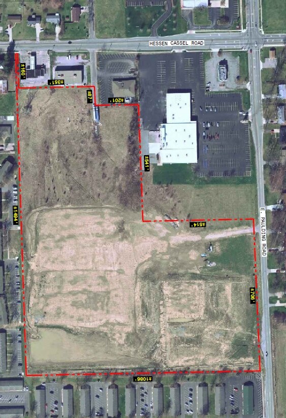
3420 E Paulding Rd
02-13-29-101-008.000-070
22.99 AC TR N 1/2 NW 1/4 W OF BUNT DR SEC 29 EX 2.891 AC TR SOLD & EX R/W & E 180 OF W 830 OF N 550FT NW1/4 SEC 29
Religious
ALLEN
B and X Area of moderate flood hazard, usually the area between the limits of the 100-year and 500-year floods.
Indiana
2025
220.99 AC
2025
South Fort Wayne
011302
Fort Wayne
27,060 SF
Fort Wayne, IN
NEARBY LISTINGS FOR SALE OR LEASE
DEMOGRAPHICS near 3420 E Paulding Rd
1 mile
3 mile
5 mile
2025 Total Population
10,026
59,009
136,812
2030 Population
10,470
61,150
141,466
Pop Growth 2025-2030
+ 4.43%
+ 3.63%
+ 3.40%
Average Age
35
35
37
2025 Total Households
3,278
21,283
54,599
HH Growth 2025-2030
+ 4.48%
+ 3.67%
+ 3.49%
Median Household Inc
$47,889
$42,170
$45,739
Avg Household Size
3.00
2.70
2.40
2025 Avg HH Vehicles
2.00
2.00
2.00
Median Home Value
$153,708
$126,667
$153,608
Median Year Built
1971
1963
1961
Nearby Places
Map Layers
Map Styles
 Street
 Aerial
Layers
 Traffic
 Biking
Places
Listings with unknown addresses are not visible on the map
- Restaurants
- Banks
- Shops
- Fitness
- Groceries
PUBLIC TRANSPORTATION
AIRPORT
Fort Wayne International
Drive
Walk
Distance
Fort Wayne International
19 min
9.6 mi
Freight Ports
Port of Toledo
Drive
Walk
Distance
Port of Toledo
138 min
105.9 mi
Nearby Properties
Address
Land Use
TOTAL SIZE
Lot Size
Zoning
Address
Land Use
TOTAL SIZE
Lot Size
Zoning
342,000 SF
5,878.37 AC
Address
Land Use
TOTAL SIZE
Lot Size
Zoning
385,470 SF
36.85 AC
Address
Land Use
TOTAL SIZE
Lot Size
Zoning
270,448 SF
41.83 AC
Address
Land Use
TOTAL SIZE
Lot Size
Zoning
97,125 SF
152.07 AC
Address
Land Use
TOTAL SIZE
Lot Size
Zoning
300,402 SF
259.60 AC
Address
Land Use
TOTAL SIZE
Lot Size
Zoning
217,151 SF
207.20 AC
Address
Land Use
TOTAL SIZE
Lot Size
Zoning
180,813 SF
246 AC
Address
Land Use
TOTAL SIZE
Lot Size
Zoning
167,836 SF
4.30 AC
Address
Land Use
TOTAL SIZE
Lot Size
Zoning
43,122 SF
11.44 AC
Address
Land Use
TOTAL SIZE
Lot Size
Zoning
243,087 SF
324.91 AC
Address
Land Use
TOTAL SIZE
Lot Size
Zoning
860,503 SF
395.56 AC
Address
Land Use
TOTAL SIZE
Lot Size
Zoning
95,432 SF
386.87 AC
Address
Land Use
TOTAL SIZE
Lot Size
Zoning
237,829 SF
498.63 AC
Address
Land Use
TOTAL SIZE
Lot Size
Zoning
169,011 SF
171.40 AC
Address
Land Use
TOTAL SIZE
Lot Size
Zoning
398,376 SF
31.30 AC
Address
Land Use
TOTAL SIZE
Lot Size
Zoning
149,627 SF
65.32 AC
Address
Land Use
TOTAL SIZE
Lot Size
Zoning
72,383 SF
10 AC
Address
Land Use
TOTAL SIZE
Lot Size
Zoning
174,206 SF
10.50 AC
Address
Land Use
TOTAL SIZE
Lot Size
Zoning
101,294 SF
10.08 AC
Address
Land Use
TOTAL SIZE
Lot Size
Zoning
186,975 SF
14.79 AC
Address
Land Use
TOTAL SIZE
Lot Size
Zoning
97,280 SF
103 AC
Address
Land Use
TOTAL SIZE
Lot Size
Zoning
2,988 SF
2,633.38 AC
Address
Land Use
TOTAL SIZE
Lot Size
Zoning
113,012 SF
6.71 AC
Address
Land Use
TOTAL SIZE
Lot Size
Zoning
121,790 SF
94.43 AC
Address
Land Use
TOTAL SIZE
Lot Size
Zoning
30,400 SF
132.94 AC
Address
Land Use
TOTAL SIZE
Lot Size
Zoning
155,867 SF
218.80 AC
Address
Land Use
TOTAL SIZE
Lot Size
Zoning
163,842 SF
130.90 AC
Address
Land Use
TOTAL SIZE
Lot Size
Zoning
494,024 SF
350.49 AC
Address
Land Use
TOTAL SIZE
Lot Size
Zoning
160,526 SF
433.70 AC
The World's #1 Commercial Real Estate Marketplace
Connect with us
© 2026 CoStar Group
The information above has been obtained from sources believed reliable. While we do not doubt its accuracy we have not verified it and make no guarantee, warranty or representation about it. It is your responsibility to independently confirm its accuracy and completeness. Any projections, opinions, assumptions, or estimates used are for example only and do not represent the current or future performance of the property. The value of this transaction to you depends on tax and other factors which should be evaluated by your tax, financial, and legal advisors. You and your advisors should conduct a careful, independent investigation of the property to determine to your satisfaction the suitability of the property for your needs.