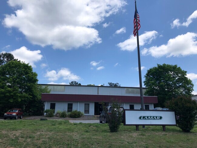
Property Record
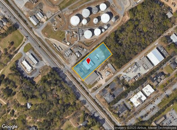
3420 Jefferson Rd, Athens, GA 30607
NEARBY LISTINGS FOR SALE OR LEASE
Property Detail
3420 Jefferson Rd
111-009
Com-St-046->00-03
Officebuilding
DEEDED ACS: 1.800
X
Clarke
13059C0014E
Georgia
2025
1.83 AC
2025
North Athens
010602
Other Market Areas
8,000 SF
Athens-Clarke County, GA
DEMOGRAPHICS near 3420 Jefferson Rd
1 Mile
3 Mile
5 Mile
2024 Total Population
4,229
37,742
92,284
2029 Population
4,250
37,856
93,238
Pop Growth 2024-2029
+ 0.50%
+ 0.30%
+ 1.03%
Average Age
38
36
34
2024 Total Households
1,497
15,769
35,975
HH Growth 2024-2029
+ 0.73%
+ 0.27%
+ 0.99%
Median Household Inc
$57,499
$48,721
$49,101
Avg Household Size
2.60
2.30
2.20
2024 Avg HH Vehicles
2.00
2.00
2.00
Median Home Value
$218,735
$254,298
$269,829
Median Year Built
1979
1980
1985
Nearby Places
Map Layers
Map Styles
 Street
 Aerial
- Restaurants
- Banks
- Shops
- Fitness
- Groceries
SALE & LEASE HISTORY
LISTING DATE
SALE/LEASE

May 04, 2020
For Lease
Nearby Properties
Address
Land Use
TOTAL SIZE
Lot Size
Zoning
Address
Land Use
TOTAL SIZE
Lot Size
Zoning
11.36 AC
G
Address
Land Use
TOTAL SIZE
Lot Size
Zoning
163,904 SF
3.75 AC
C-D
Address
Land Use
TOTAL SIZE
Lot Size
Zoning
85,608 SF
63.75 AC
RM-2
Address
Land Use
TOTAL SIZE
Lot Size
Zoning
184,293 SF
1.84 AC
C-D
Address
Land Use
TOTAL SIZE
Lot Size
Zoning
56.15 AC
G
Address
Land Use
TOTAL SIZE
Lot Size
Zoning
20 AC
G
Address
Land Use
TOTAL SIZE
Lot Size
Zoning
97,317 SF
24.31 AC
C-G
Address
Land Use
TOTAL SIZE
Lot Size
Zoning
18.47 AC
C-G
Address
Land Use
TOTAL SIZE
Lot Size
Zoning
112,071 SF
5.27 AC
E-O
Address
Land Use
TOTAL SIZE
Lot Size
Zoning
66,200 SF
13.35 AC
G
Address
Land Use
TOTAL SIZE
Lot Size
Zoning
36.74 AC
G
Address
Land Use
TOTAL SIZE
Lot Size
Zoning
8,357 SF
22.38 AC
RM-2
Address
Land Use
TOTAL SIZE
Lot Size
Zoning
118,239 SF
2.80 AC
C-D(ND)
Address
Land Use
TOTAL SIZE
Lot Size
Zoning
8,423 SF
1.07 AC
C-D
Address
Land Use
TOTAL SIZE
Lot Size
Zoning
77,919 SF
8 AC
E-I
Address
Land Use
TOTAL SIZE
Lot Size
Zoning
64,466 SF
1.08 AC
C-D
Address
Land Use
TOTAL SIZE
Lot Size
Zoning
83,755 SF
1.70 AC
C-D
Address
Land Use
TOTAL SIZE
Lot Size
Zoning
1,672 SF
23.70 AC
RM-2
Address
Land Use
TOTAL SIZE
Lot Size
Zoning
38,928 SF
18.56 AC
RM-2
Address
Land Use
TOTAL SIZE
Lot Size
Zoning
48,400 SF
12 AC
RM-2
Address
Land Use
TOTAL SIZE
Lot Size
Zoning
9,956 SF
7.20 AC
E-O(PD)
Address
Land Use
TOTAL SIZE
Lot Size
Zoning
49.58 AC
G
Address
Land Use
TOTAL SIZE
Lot Size
Zoning
88,251 SF
8.16 AC
C-G
Address
Land Use
TOTAL SIZE
Lot Size
Zoning
10,490 SF
5.16 AC
C-G
Address
Land Use
TOTAL SIZE
Lot Size
Zoning
2,602 SF
9.95 AC
C-G
Address
Land Use
TOTAL SIZE
Lot Size
Zoning
13,224 SF
3.80 AC
C-D
Address
Land Use
TOTAL SIZE
Lot Size
Zoning
58,706 SF
12.86 AC
C-G
Address
Land Use
TOTAL SIZE
Lot Size
Zoning
60,737 SF
2.66 AC
C-D
Address
Land Use
TOTAL SIZE
Lot Size
Zoning
1.46 AC
C-D
Address
Land Use
TOTAL SIZE
Lot Size
Zoning
66,640 SF
2.33 AC
C-D
The World's #1 Commercial Real Estate Marketplace
Connect with us
© 2025 CoStar Group
The information above has been obtained from sources believed reliable. While we do not doubt its accuracy we have not verified it and make no guarantee, warranty or representation about it. It is your responsibility to independently confirm its accuracy and completeness. Any projections, opinions, assumptions, or estimates used are for example only and do not represent the current or future performance of the property. The value of this transaction to you depends on tax and other factors which should be evaluated by your tax, financial, and legal advisors. You and your advisors should conduct a careful, independent investigation of the property to determine to your satisfaction the suitability of the property for your needs.