Property Record
3421 Mcabee Rd, Greer, SC 29651
NEARBY LISTINGS FOR SALE OR LEASE
-
-
View all Greer listings for sale on LoopNet.com
Property Detail
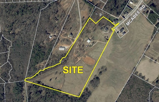
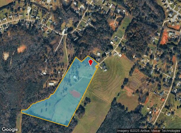
3421 Mcabee Rd
Greenville-Anderson-Greer, SC
Survey For Michael A & Shirley F Studley
0631.08-01-008.07
MAP 0631.08; A
Agriculturalland
Greenville
X
South Carolina
45045C0332F
008.07
2025
22.79 AC
2025
Travelers Rest
002405
Greenville/Spartanburg
1,852 SF
DEMOGRAPHICS near 3421 Mcabee Rd
1 mile
3 mile
5 mile
2024 Total Population
3,333
20,315
58,303
2029 Population
3,702
22,502
64,830
Pop Growth 2024-2029
+ 11.07%
+ 10.77%
+ 11.19%
Average Age
40
41
41
2024 Total Households
1,237
7,724
22,996
HH Growth 2024-2029
+ 11.16%
+ 10.84%
+ 11.30%
Median Household Inc
$86,830
$80,834
$65,971
Avg Household Size
2.70
2.60
2.50
2024 Avg HH Vehicles
2.00
2.00
2.00
Median Home Value
$267,833
$257,474
$236,830
Median Year Built
2005
2001
1995
Nearby Places
Map Layers
Map Styles
 Street
 Aerial
Transit
 Traffic
 Biking
Places
Listings with unknown addresses are not visible on the map
- Restaurants
- Banks
- Shops
- Fitness
- Groceries
PUBLIC TRANSPORTATION
AIRPORT
Greenville Spartanburg International
Drive
Walk
Distance
Greenville Spartanburg International
23 min
10.7 mi
Freight Ports
North Charleston Terminal
Drive
Walk
Distance
North Charleston Terminal
244 min
209.4 mi
SALE & LEASE HISTORY
LISTING DATE
SALE/LEASE

Sep 24, 2016
For Sale
Nearby Properties
Address
Land Use
TOTAL SIZE
Lot Size
Zoning
Address
Land Use
TOTAL SIZE
Lot Size
Zoning
14.20 AC
UNZONED
Address
Land Use
TOTAL SIZE
Lot Size
Zoning
34.30 AC
UNZONED
Address
Land Use
TOTAL SIZE
Lot Size
Zoning
83.58 AC
RS
Address
Land Use
TOTAL SIZE
Lot Size
Zoning
70.66 AC
RS
Address
Land Use
TOTAL SIZE
Lot Size
Zoning
74.10 AC
RS
Address
Land Use
TOTAL SIZE
Lot Size
Zoning
71.11 AC
RS
Address
Land Use
TOTAL SIZE
Lot Size
Zoning
2,341 SF
59.60 AC
PDR
Address
Land Use
TOTAL SIZE
Lot Size
Zoning
56.94 AC
Address
Land Use
TOTAL SIZE
Lot Size
Zoning
3,649 SF
16.04 AC
UNZONED
Address
Land Use
TOTAL SIZE
Lot Size
Zoning
60.30 AC
RS
Address
Land Use
TOTAL SIZE
Lot Size
Zoning
58.18 AC
UNZONED
Address
Land Use
TOTAL SIZE
Lot Size
Zoning
13,344 SF
125 AC
Address
Land Use
TOTAL SIZE
Lot Size
Zoning
33.77 AC
UNZONED
Address
Land Use
TOTAL SIZE
Lot Size
Zoning
5.29 AC
UNZONED
Address
Land Use
TOTAL SIZE
Lot Size
Zoning
14.10 AC
RS
Address
Land Use
TOTAL SIZE
Lot Size
Zoning
4,088 SF
1.67 AC
Address
Land Use
TOTAL SIZE
Lot Size
Zoning
0.57 AC
Address
Land Use
TOTAL SIZE
Lot Size
Zoning
720 SF
22.40 AC
RS
Address
Land Use
TOTAL SIZE
Lot Size
Zoning
22.10 AC
RS
Address
Land Use
TOTAL SIZE
Lot Size
Zoning
2,164 SF
33.02 AC
Address
Land Use
TOTAL SIZE
Lot Size
Zoning
3,013 SF
0.77 AC
UNZONED
Address
Land Use
TOTAL SIZE
Lot Size
Zoning
21.14 AC
RS
Address
Land Use
TOTAL SIZE
Lot Size
Zoning
1,998 SF
15.77 AC
RS
Address
Land Use
TOTAL SIZE
Lot Size
Zoning
1,303 SF
11.80 AC
UNZONED
Address
Land Use
TOTAL SIZE
Lot Size
Zoning
2,289 SF
0.94 AC
RS
Address
Land Use
TOTAL SIZE
Lot Size
Zoning
13.97 AC
Address
Land Use
TOTAL SIZE
Lot Size
Zoning
1,519 SF
9.30 AC
UNZONED
Address
Land Use
TOTAL SIZE
Lot Size
Zoning
2,102 SF
0.48 AC
UNZONED
Address
Land Use
TOTAL SIZE
Lot Size
Zoning
3.79 AC
Address
Land Use
TOTAL SIZE
Lot Size
Zoning
952 SF
14.28 AC
RS
The World's #1 Commercial Real Estate Marketplace
Connect with us
© 2026 CoStar Group
The information above has been obtained from sources believed reliable. While we do not doubt its accuracy we have not verified it and make no guarantee, warranty or representation about it. It is your responsibility to independently confirm its accuracy and completeness. Any projections, opinions, assumptions, or estimates used are for example only and do not represent the current or future performance of the property. The value of this transaction to you depends on tax and other factors which should be evaluated by your tax, financial, and legal advisors. You and your advisors should conduct a careful, independent investigation of the property to determine to your satisfaction the suitability of the property for your needs.