Property Record
34211 N Black Mountain Pkwy, Cave Creek, AZ 85331

NEARBY LISTINGS FOR SALE OR LEASE
Property Detail
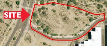
34211 N Black Mountain Pkwy
Phoenix-Mesa-Scottsdale, AZ
Black Mountain Commerce Park Amd
211-46-329
BLACK MOUNTAIN COMMERCE PARK AMD MCR 773-37
Industrialacreage
Maricopa
X
Arizona
04013C0890M
1
2025
2.47 AC
2025
N Phoenix/Cave Creek
612500
Phoenix
DEMOGRAPHICS near 34211 N Black Mountain Pkwy
1 Mile
3 Mile
5 Mile
2024 Total Population
4,165
24,029
50,243
2029 Population
4,524
26,138
54,728
Pop Growth 2024-2029
+ 8.62%
+ 8.78%
+ 8.93%
Average Age
46
48
49
2024 Total Households
1,662
9,812
20,616
HH Growth 2024-2029
+ 8.66%
+ 8.93%
+ 9.14%
Median Household Inc
$119,378
$124,447
$124,804
Avg Household Size
2.50
2.40
2.40
2024 Avg HH Vehicles
2.00
2.00
2.00
Median Home Value
$489,119
$658,767
$690,839
Median Year Built
2002
1997
1996
Nearby Places
Map Layers
Map Styles
 Street
 Aerial
- Restaurants
- Banks
- Shops
- Fitness
- Groceries
PUBLIC TRANSPORTATION
AIRPORT
Phoenix Sky Harbor International
DRIVE
WALK
Distance
Phoenix Sky Harbor International
41 min
31.7 mi
Freight Ports
Port of San Diego
DRIVE
WALK
Distance
Port of San Diego
1 min
308.8 mi
SALE & LEASE HISTORY
LISTING DATE
SALE/LEASE

Aug 23, 2024
For Sale
Nearby Properties
Address
Land Use
TOTAL SIZE
Lot Size
Zoning
Address
Land Use
TOTAL SIZE
Lot Size
Zoning
557,887 SF
163.54 AC
R-43
Address
Land Use
TOTAL SIZE
Lot Size
Zoning
123,518 SF
14.92 AC
C-C
Address
Land Use
TOTAL SIZE
Lot Size
Zoning
10 SF
13.75 AC
R-35
Address
Land Use
TOTAL SIZE
Lot Size
Zoning
126,785 SF
17.94 AC
C-G
Address
Land Use
TOTAL SIZE
Lot Size
Zoning
79,429 SF
17.76 AC
R-35
Address
Land Use
TOTAL SIZE
Lot Size
Zoning
55,995 SF
17.95 AC
R-35
Address
Land Use
TOTAL SIZE
Lot Size
Zoning
30,172 SF
14.13 AC
S1
Address
Land Use
TOTAL SIZE
Lot Size
Zoning
70.35 AC
R-35
Address
Land Use
TOTAL SIZE
Lot Size
Zoning
115,432 SF
12.98 AC
C-C
Address
Land Use
TOTAL SIZE
Lot Size
Zoning
74,132 SF
7.93 AC
PAD
Address
Land Use
TOTAL SIZE
Lot Size
Zoning
6,526 SF
76.43 AC
DR89
Address
Land Use
TOTAL SIZE
Lot Size
Zoning
82,175 SF
8.65 AC
C-C
Address
Land Use
TOTAL SIZE
Lot Size
Zoning
47,830 SF
5.22 AC
R-43
Address
Land Use
TOTAL SIZE
Lot Size
Zoning
600 SF
38.67 AC
R-43
Address
Land Use
TOTAL SIZE
Lot Size
Zoning
140,290 SF
5.13 AC
CP/GCP
Address
Land Use
TOTAL SIZE
Lot Size
Zoning
45,425 SF
22.94 AC
R-43AG
Address
Land Use
TOTAL SIZE
Lot Size
Zoning
32,944 SF
6.89 AC
R-70
Address
Land Use
TOTAL SIZE
Lot Size
Zoning
60,652 SF
6.82 AC
C-C
Address
Land Use
TOTAL SIZE
Lot Size
Zoning
31,823 SF
1.80 AC
R-43
Address
Land Use
TOTAL SIZE
Lot Size
Zoning
21,828 SF
58.46 AC
R-43
Address
Land Use
TOTAL SIZE
Lot Size
Zoning
55,478 SF
5.24 AC
C-C
Address
Land Use
TOTAL SIZE
Lot Size
Zoning
1,010.34 AC
R-35
Address
Land Use
TOTAL SIZE
Lot Size
Zoning
102,591 SF
3.81 AC
C-C
Address
Land Use
TOTAL SIZE
Lot Size
Zoning
40,743 SF
6.90 AC
C-N
Address
Land Use
TOTAL SIZE
Lot Size
Zoning
12.17 AC
R-6
Address
Land Use
TOTAL SIZE
Lot Size
Zoning
34,888 SF
4.69 AC
S-1
Address
Land Use
TOTAL SIZE
Lot Size
Zoning
38,493 SF
1.88 AC
C-C
Address
Land Use
TOTAL SIZE
Lot Size
Zoning
27,015 SF
3.14 AC
C-2
Address
Land Use
TOTAL SIZE
Lot Size
Zoning
315.05 AC
R-43
The World's #1 Commercial Real Estate Marketplace
Connect with us
© 2025 CoStar Group
The information above has been obtained from sources believed reliable. While we do not doubt its accuracy we have not verified it and make no guarantee, warranty or representation about it. It is your responsibility to independently confirm its accuracy and completeness. Any projections, opinions, assumptions, or estimates used are for example only and do not represent the current or future performance of the property. The value of this transaction to you depends on tax and other factors which should be evaluated by your tax, financial, and legal advisors. You and your advisors should conduct a careful, independent investigation of the property to determine to your satisfaction the suitability of the property for your needs.