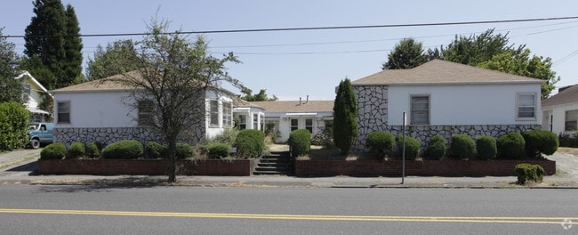
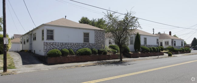
Property Record
3424 Se 52Nd Ave, Portland, OR 97206

Property Detail
3424 Se 52Nd Ave
R149301
EAST CRESTON, N 144 OF S 244 OF W 100 OF BLOCK 22
Multifamilydwelling
Multnomah
RM1
Oregon
B and X Area of moderate flood hazard, usually the area between the limits of the 100-year and 500-year floods.
22
2025
0.33 AC
2025
South Tabor
000801
Portland
5,328 SF
Portland-Vancouver-Hillsboro, OR-WA
NEARBY LISTINGS FOR SALE OR LEASE
DEMOGRAPHICS near 3424 Se 52Nd Ave
1 mile
3 mile
5 mile
2025 Total Population
28,181
203,666
507,174
2030 Population
27,612
200,921
502,741
Pop Growth 2025-2030
(2.02%)
(1.35%)
(0.87%)
Average Age
40
40
41
2025 Total Households
12,258
88,278
223,213
HH Growth 2025-2030
(2.26%)
(1.55%)
(0.95%)
Median Household Inc
$100,764
$91,838
$85,940
Avg Household Size
2.20
2.20
2.10
2025 Avg HH Vehicles
2.00
2.00
1.00
Median Home Value
$659,223
$614,677
$602,676
Median Year Built
1952
1954
1965
Nearby Places
Map Layers
Map Styles
 Street
 Aerial
Transit
 Traffic
 Biking
Places
Listings with unknown addresses are not visible on the map
- Restaurants
- Banks
- Shops
- Fitness
- Groceries
PUBLIC TRANSPORTATION
COMMUTER RAIL
Drive
Walk
Distance
15 min
5.2 mi
AIRPORT
Portland International
Drive
Walk
Distance
Portland International
20 min
10.3 mi
Freight Ports
Port of Portland
Drive
Walk
Distance
Port of Portland
17 min
7.5 mi
Nearby Properties
Address
Land Use
TOTAL SIZE
Lot Size
Zoning
Address
Land Use
TOTAL SIZE
Lot Size
Zoning
822,867 SF
103.39 AC
CI1
Address
Land Use
TOTAL SIZE
Lot Size
Zoning
1.09 AC
EX
Address
Land Use
TOTAL SIZE
Lot Size
Zoning
1,024 SF
15.92 AC
OS
Address
Land Use
TOTAL SIZE
Lot Size
Zoning
178,785 SF
10.20 AC
R5
Address
Land Use
TOTAL SIZE
Lot Size
Zoning
7.78 AC
EX
Address
Land Use
TOTAL SIZE
Lot Size
Zoning
183,664 SF
8.96 AC
R5
Address
Land Use
TOTAL SIZE
Lot Size
Zoning
280,069 SF
18.31 AC
IR
Address
Land Use
TOTAL SIZE
Lot Size
Zoning
473,746 SF
1.68 AC
Address
Land Use
TOTAL SIZE
Lot Size
Zoning
Address
Land Use
TOTAL SIZE
Lot Size
Zoning
147,334 SF
10.92 AC
IG1
Address
Land Use
TOTAL SIZE
Lot Size
Zoning
250,280 SF
23.86 AC
IR
Address
Land Use
TOTAL SIZE
Lot Size
Zoning
31,878 SF
15.95 AC
IG2
Address
Land Use
TOTAL SIZE
Lot Size
Zoning
54,676 SF
190.32 AC
OS
Address
Land Use
TOTAL SIZE
Lot Size
Zoning
198,107 SF
4.03 AC
R2.5
Address
Land Use
TOTAL SIZE
Lot Size
Zoning
42,839,055 SF
19.25 AC
CI1
Address
Land Use
TOTAL SIZE
Lot Size
Zoning
152,575 SF
5.32 AC
EG1
Address
Land Use
TOTAL SIZE
Lot Size
Zoning
453,461 SF
1.16 AC
CX
Address
Land Use
TOTAL SIZE
Lot Size
Zoning
317,656 SF
21.94 AC
CX
Address
Land Use
TOTAL SIZE
Lot Size
Zoning
44,644 SF
2.18 AC
R2
Address
Land Use
TOTAL SIZE
Lot Size
Zoning
64,673 SF
NULL
Address
Land Use
TOTAL SIZE
Lot Size
Zoning
100,217 SF
1.99 AC
R5
Address
Land Use
TOTAL SIZE
Lot Size
Zoning
88,789 SF
1.48 AC
EX
Address
Land Use
TOTAL SIZE
Lot Size
Zoning
258,082 SF
2.80 AC
CS
Address
Land Use
TOTAL SIZE
Lot Size
Zoning
362,725 SF
16.52 AC
IG1
Address
Land Use
TOTAL SIZE
Lot Size
Zoning
279,607 SF
1.67 AC
CX
Address
Land Use
TOTAL SIZE
Lot Size
Zoning
56,072 SF
11.48 AC
OS
Address
Land Use
TOTAL SIZE
Lot Size
Zoning
205,034 SF
0.38 AC
RM1
Address
Land Use
TOTAL SIZE
Lot Size
Zoning
2,108 SF
12.08 AC
HDR
Address
Land Use
TOTAL SIZE
Lot Size
Zoning
113,582 SF
5.29 AC
R5
Address
Land Use
TOTAL SIZE
Lot Size
Zoning
361,241 SF
1.80 AC
CI2
The World's #1 Commercial Real Estate Marketplace
Connect with us
© 2026 CoStar Group
The information above has been obtained from sources believed reliable. While we do not doubt its accuracy we have not verified it and make no guarantee, warranty or representation about it. It is your responsibility to independently confirm its accuracy and completeness. Any projections, opinions, assumptions, or estimates used are for example only and do not represent the current or future performance of the property. The value of this transaction to you depends on tax and other factors which should be evaluated by your tax, financial, and legal advisors. You and your advisors should conduct a careful, independent investigation of the property to determine to your satisfaction the suitability of the property for your needs.