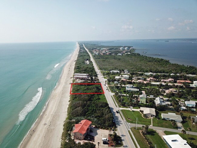
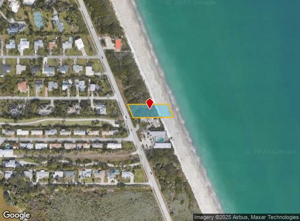
Property Record
3425 S Highway A1a, Melbourne Beach, FL 32951
NEARBY LISTINGS FOR SALE OR LEASE
Property Detail
3425 S Highway A1a
Palm Bay-Melbourne-Titusville, FL
Averill Farms Subd
28-38-28-GD-0000L.0-0005.00
AVERILL FARMS SUBD LOT 5 BLK L
Recreationalacreage
Brevard
VE
Florida
12009C0618H
5
2024
0.56 AC
2025
Brevard County
066103
Orlando
DEMOGRAPHICS near 3425 S Highway A1a
1 Mile
3 Mile
5 Mile
2024 Total Population
1,803
12,170
39,167
2029 Population
2,031
13,467
43,170
Pop Growth 2024-2029
+ 12.65%
+ 10.66%
+ 10.22%
Average Age
59
51
47
2024 Total Households
934
5,702
17,235
HH Growth 2024-2029
+ 12.42%
+ 10.61%
+ 10.08%
Median Household Inc
$60,545
$64,399
$55,569
Avg Household Size
1.90
2.10
2.20
2024 Avg HH Vehicles
1.00
2.00
2.00
Median Home Value
$343,777
$341,212
$291,306
Median Year Built
1987
1981
1983
Nearby Places
Map Layers
Map Styles
 Street
 Aerial
- Restaurants
- Banks
- Shops
- Fitness
- Groceries
PUBLIC TRANSPORTATION
AIRPORT
Melbourne Orlando International
DRIVE
WALK
Distance
Melbourne Orlando International
24 min
11.2 mi
Freight Ports
Port Canaveral
DRIVE
WALK
Distance
Port Canaveral
55 min
27.6 mi
SALE & LEASE HISTORY
LISTING DATE
SALE/LEASE

Jul 13, 2018
For Sale
Nearby Properties
Address
Land Use
TOTAL SIZE
Lot Size
Zoning
Address
Land Use
TOTAL SIZE
Lot Size
Zoning
326,454 SF
14.20 AC
RM20
Address
Land Use
TOTAL SIZE
Lot Size
Zoning
39.75 AC
GML
Address
Land Use
TOTAL SIZE
Lot Size
Zoning
2,366 SF
32.43 AC
SR
Address
Land Use
TOTAL SIZE
Lot Size
Zoning
762 SF
49.89 AC
GML
Address
Land Use
TOTAL SIZE
Lot Size
Zoning
135,917 SF
2.92 AC
HC
Address
Land Use
TOTAL SIZE
Lot Size
Zoning
23,945 SF
142.13 AC
GML
Address
Land Use
TOTAL SIZE
Lot Size
Zoning
35.96 AC
GML
Address
Land Use
TOTAL SIZE
Lot Size
Zoning
76,534 SF
4.33 AC
HC
Address
Land Use
TOTAL SIZE
Lot Size
Zoning
109,650 SF
10.32 AC
CG
Address
Land Use
TOTAL SIZE
Lot Size
Zoning
77,817 SF
17.84 AC
2RS
Address
Land Use
TOTAL SIZE
Lot Size
Zoning
6.48 AC
GML
Address
Land Use
TOTAL SIZE
Lot Size
Zoning
5.83 AC
GML
Address
Land Use
TOTAL SIZE
Lot Size
Zoning
78,357 SF
8.47 AC
BU1
Address
Land Use
TOTAL SIZE
Lot Size
Zoning
31.07 AC
GML
Address
Land Use
TOTAL SIZE
Lot Size
Zoning
80,425 SF
12.78 AC
HC
Address
Land Use
TOTAL SIZE
Lot Size
Zoning
1,535 SF
3.85 AC
GML
Address
Land Use
TOTAL SIZE
Lot Size
Zoning
4.23 AC
GML
Address
Land Use
TOTAL SIZE
Lot Size
Zoning
12.84 AC
GML
Address
Land Use
TOTAL SIZE
Lot Size
Zoning
14.28 AC
SR
Address
Land Use
TOTAL SIZE
Lot Size
Zoning
27,837 SF
8.24 AC
IN(L)
Address
Land Use
TOTAL SIZE
Lot Size
Zoning
40,192 SF
6.92 AC
HC
Address
Land Use
TOTAL SIZE
Lot Size
Zoning
4.02 AC
GML
Address
Land Use
TOTAL SIZE
Lot Size
Zoning
2.82 AC
RU-1-11
Address
Land Use
TOTAL SIZE
Lot Size
Zoning
8.15 AC
SR
Address
Land Use
TOTAL SIZE
Lot Size
Zoning
8,853 SF
15.94 AC
CP
Address
Land Use
TOTAL SIZE
Lot Size
Zoning
2.24 AC
GML
Address
Land Use
TOTAL SIZE
Lot Size
Zoning
12.49 AC
HC
Address
Land Use
TOTAL SIZE
Lot Size
Zoning
1.92 AC
GML
Address
Land Use
TOTAL SIZE
Lot Size
Zoning
1.60 AC
GML
Address
Land Use
TOTAL SIZE
Lot Size
Zoning
43,251 SF
3.27 AC
RMH
The World's #1 Commercial Real Estate Marketplace
Connect with us
© 2025 CoStar Group
The information above has been obtained from sources believed reliable. While we do not doubt its accuracy we have not verified it and make no guarantee, warranty or representation about it. It is your responsibility to independently confirm its accuracy and completeness. Any projections, opinions, assumptions, or estimates used are for example only and do not represent the current or future performance of the property. The value of this transaction to you depends on tax and other factors which should be evaluated by your tax, financial, and legal advisors. You and your advisors should conduct a careful, independent investigation of the property to determine to your satisfaction the suitability of the property for your needs.