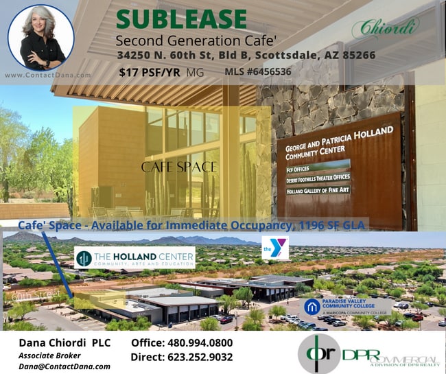
Property Record
34250 N 60Th St, Scottsdale, AZ 85266


NEARBY LISTINGS FOR SALE OR LEASE
Property Detail
34250 N 60Th St
Phoenix-Mesa-Scottsdale, AZ
Desert Foothills Ymca
211-61-756
DESERT FOOTHILLS YMCA MCR 1017-31
Communitycenter
Maricopa
X
Arizona
04013C0890M
2
0
5.22 AC
2025
Carefree
613100
Phoenix
47,830 SF
DEMOGRAPHICS near 34250 N 60Th St
1 Mile
3 Mile
5 Mile
2024 Total Population
3,225
28,079
50,433
2029 Population
3,543
30,768
55,112
Pop Growth 2024-2029
+ 9.86%
+ 9.58%
+ 9.28%
Average Age
54
52
51
2024 Total Households
1,403
11,829
21,126
HH Growth 2024-2029
+ 10.12%
+ 9.80%
+ 9.52%
Median Household Inc
$141,579
$128,394
$128,272
Avg Household Size
2.30
2.30
2.40
2024 Avg HH Vehicles
2.00
2.00
2.00
Median Home Value
$778,008
$729,766
$729,943
Median Year Built
1996
1998
1997
Nearby Places
Map Layers
Map Styles
 Street
 Aerial
- Restaurants
- Banks
- Shops
- Fitness
- Groceries
PUBLIC TRANSPORTATION
AIRPORT
Phoenix Sky Harbor International
DRIVE
WALK
Distance
Phoenix Sky Harbor International
48 min
31.4 mi
Freight Ports
Port of San Diego
DRIVE
WALK
Distance
Port of San Diego
430 min
380.5 mi
SALE & LEASE HISTORY
LISTING DATE
SALE/LEASE

Aug 30, 2022
For Lease
Nearby Properties
Address
Land Use
TOTAL SIZE
Lot Size
Zoning
Address
Land Use
TOTAL SIZE
Lot Size
Zoning
557,887 SF
163.54 AC
R-43
Address
Land Use
TOTAL SIZE
Lot Size
Zoning
170,385 SF
23.82 AC
C-C
Address
Land Use
TOTAL SIZE
Lot Size
Zoning
140,303 SF
29.18 AC
R-4R
Address
Land Use
TOTAL SIZE
Lot Size
Zoning
123,518 SF
14.92 AC
C-C
Address
Land Use
TOTAL SIZE
Lot Size
Zoning
10 SF
13.75 AC
R-35
Address
Land Use
TOTAL SIZE
Lot Size
Zoning
126,785 SF
17.94 AC
C-G
Address
Land Use
TOTAL SIZE
Lot Size
Zoning
79,429 SF
17.76 AC
R-35
Address
Land Use
TOTAL SIZE
Lot Size
Zoning
55,995 SF
17.95 AC
R-35
Address
Land Use
TOTAL SIZE
Lot Size
Zoning
30,172 SF
14.13 AC
S1
Address
Land Use
TOTAL SIZE
Lot Size
Zoning
70.35 AC
R-35
Address
Land Use
TOTAL SIZE
Lot Size
Zoning
115,432 SF
12.98 AC
C-C
Address
Land Use
TOTAL SIZE
Lot Size
Zoning
67,241 SF
9.40 AC
R-43
Address
Land Use
TOTAL SIZE
Lot Size
Zoning
74,132 SF
7.93 AC
PAD
Address
Land Use
TOTAL SIZE
Lot Size
Zoning
130,394 SF
10.22 AC
C-2
Address
Land Use
TOTAL SIZE
Lot Size
Zoning
6,526 SF
76.43 AC
DR89
Address
Land Use
TOTAL SIZE
Lot Size
Zoning
82,175 SF
8.65 AC
C-C
Address
Land Use
TOTAL SIZE
Lot Size
Zoning
600 SF
38.67 AC
R-43
Address
Land Use
TOTAL SIZE
Lot Size
Zoning
84,248 SF
6.68 AC
C-C
Address
Land Use
TOTAL SIZE
Lot Size
Zoning
140,290 SF
5.13 AC
CP/GCP
Address
Land Use
TOTAL SIZE
Lot Size
Zoning
45,425 SF
22.94 AC
R-43AG
Address
Land Use
TOTAL SIZE
Lot Size
Zoning
32,944 SF
6.89 AC
R-70
Address
Land Use
TOTAL SIZE
Lot Size
Zoning
60,652 SF
6.82 AC
C-C
Address
Land Use
TOTAL SIZE
Lot Size
Zoning
31,823 SF
1.80 AC
R-43
Address
Land Use
TOTAL SIZE
Lot Size
Zoning
65,744 SF
2.05 AC
Address
Land Use
TOTAL SIZE
Lot Size
Zoning
21,828 SF
58.46 AC
R-43
Address
Land Use
TOTAL SIZE
Lot Size
Zoning
38,754 SF
205.79 AC
R1-130
Address
Land Use
TOTAL SIZE
Lot Size
Zoning
102,591 SF
3.81 AC
C-C
Address
Land Use
TOTAL SIZE
Lot Size
Zoning
40,743 SF
6.90 AC
C-N
Address
Land Use
TOTAL SIZE
Lot Size
Zoning
34,888 SF
4.69 AC
S-1
The World's #1 Commercial Real Estate Marketplace
Connect with us
© 2026 CoStar Group
The information above has been obtained from sources believed reliable. While we do not doubt its accuracy we have not verified it and make no guarantee, warranty or representation about it. It is your responsibility to independently confirm its accuracy and completeness. Any projections, opinions, assumptions, or estimates used are for example only and do not represent the current or future performance of the property. The value of this transaction to you depends on tax and other factors which should be evaluated by your tax, financial, and legal advisors. You and your advisors should conduct a careful, independent investigation of the property to determine to your satisfaction the suitability of the property for your needs.