Property Record
3400 Evergreen Cir, West Sacramento, CA 95691
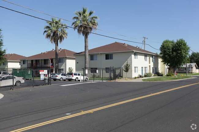

This Property Is For Sale
NEARBY LISTINGS FOR SALE OR LEASE
Property Detail
3400 Evergreen Cir
067-100-001-000
Meadowdale Subdivision
Apartment
MAP F4 358
ARE
Yolo
06067C0160J
California
2024
0.33 AC
2025
West Sacramento
010203
Sacramento
80,608 SF
Sacramento-Roseville-Folsom, CA
DEMOGRAPHICS near 3400 Evergreen Cir
1 Mile
3 Mile
5 Mile
2024 Total Population
4,617
62,580
198,643
2029 Population
4,661
63,676
201,244
Pop Growth 2024-2029
+ 0.95%
+ 1.75%
+ 1.31%
Average Age
37
38
39
2024 Total Households
1,759
23,943
82,445
HH Growth 2024-2029
+ 0.80%
+ 1.97%
+ 1.49%
Median Household Inc
$35,207
$77,583
$78,131
Avg Household Size
2.50
2.50
2.30
2024 Avg HH Vehicles
1.00
2.00
2.00
Median Home Value
$77,718
$454,936
$507,390
Median Year Built
1972
1985
1975
Nearby Places
Map Layers
Map Styles
 Street
 Aerial
- Restaurants
- Banks
- Shops
- Fitness
- Groceries
PUBLIC TRANSPORTATION
COMMUTER RAIL
Sacramento (Capitol Corridor - Capitol Corridor Joint Powers Authority)
DRIVE
WALK
Distance
Sacramento (Capitol Corridor - Capitol Corridor Joint Powers Authority)
8 min
3.9 mi
AIRPORT
Sacramento International
DRIVE
WALK
Distance
Sacramento International
21 min
13.3 mi
Freight Ports
Port of Stockton
DRIVE
WALK
Distance
Port of Stockton
57 min
48.1 mi
Nearby Properties
Address
Land Use
TOTAL SIZE
Lot Size
Zoning
Address
Land Use
TOTAL SIZE
Lot Size
Zoning
594,942 SF
2.39 AC
C-3-SPD
Address
Land Use
TOTAL SIZE
Lot Size
Zoning
467,970 SF
4.59 AC
W-F
Address
Land Use
TOTAL SIZE
Lot Size
Zoning
R-4-PUD C-
Address
Land Use
TOTAL SIZE
Lot Size
Zoning
110,584 SF
9.76 AC
B-P
Address
Land Use
TOTAL SIZE
Lot Size
Zoning
0.13 AC
WF
Address
Land Use
TOTAL SIZE
Lot Size
Zoning
26,712 SF
1.85 AC
R-5-PUD-SP
Address
Land Use
TOTAL SIZE
Lot Size
Zoning
405,074 SF
2.39 AC
C-3-SPD
Address
Land Use
TOTAL SIZE
Lot Size
Zoning
4.41 AC
W-F
Address
Land Use
TOTAL SIZE
Lot Size
Zoning
1.04 AC
C-2-SPD
Address
Land Use
TOTAL SIZE
Lot Size
Zoning
267,053 SF
22.19 AC
M2
Address
Land Use
TOTAL SIZE
Lot Size
Zoning
R-4-PUD
Address
Land Use
TOTAL SIZE
Lot Size
Zoning
379,161 SF
22.70 AC
MU
Address
Land Use
TOTAL SIZE
Lot Size
Zoning
181,432 SF
35.96 AC
MU
Address
Land Use
TOTAL SIZE
Lot Size
Zoning
253,713 SF
24.83 AC
M-L
Address
Land Use
TOTAL SIZE
Lot Size
Zoning
218,656 SF
0.08 AC
MU
Address
Land Use
TOTAL SIZE
Lot Size
Zoning
Address
Land Use
TOTAL SIZE
Lot Size
Zoning
368,561 SF
24.69 AC
P-O
Address
Land Use
TOTAL SIZE
Lot Size
Zoning
260,285 SF
20.22 AC
C2
Address
Land Use
TOTAL SIZE
Lot Size
Zoning
7.20 AC
PD
Address
Land Use
TOTAL SIZE
Lot Size
Zoning
27.65 AC
M-3
Address
Land Use
TOTAL SIZE
Lot Size
Zoning
229,130 SF
10.64 AC
BP
Address
Land Use
TOTAL SIZE
Lot Size
Zoning
193,464 SF
0.11 AC
R3
Address
Land Use
TOTAL SIZE
Lot Size
Zoning
222,937 SF
10.18 AC
HDR
Address
Land Use
TOTAL SIZE
Lot Size
Zoning
422,059 SF
22.62 AC
MU
Address
Land Use
TOTAL SIZE
Lot Size
Zoning
195,679 SF
1.55 AC
C-3-SPD
Address
Land Use
TOTAL SIZE
Lot Size
Zoning
31.93 AC
M-3
Address
Land Use
TOTAL SIZE
Lot Size
Zoning
22.62 AC
BP
Address
Land Use
TOTAL SIZE
Lot Size
Zoning
387,420 SF
20.75 AC
MU
Address
Land Use
TOTAL SIZE
Lot Size
Zoning
209,088 SF
16.87 AC
M-L
The World's #1 Commercial Real Estate Marketplace
Connect with us
© 2026 CoStar Group
The information above has been obtained from sources believed reliable. While we do not doubt its accuracy we have not verified it and make no guarantee, warranty or representation about it. It is your responsibility to independently confirm its accuracy and completeness. Any projections, opinions, assumptions, or estimates used are for example only and do not represent the current or future performance of the property. The value of this transaction to you depends on tax and other factors which should be evaluated by your tax, financial, and legal advisors. You and your advisors should conduct a careful, independent investigation of the property to determine to your satisfaction the suitability of the property for your needs.