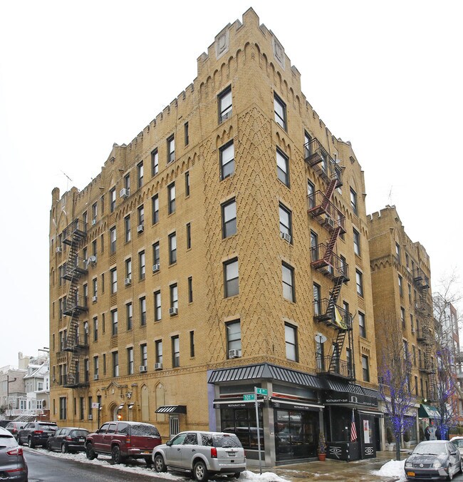
Property Record
343 101St St, Brooklyn, NY 11209

NEARBY LISTINGS FOR SALE OR LEASE
Property Detail
343 101St St
06137-0045
DOCID-2019031300737001
Apartment
Kings
X
New York
3604970331F
45
2024
0.28 AC
2025
Bay Ridge
005602
Long Island (New York)
51,000 SF
New York-Jersey City-White Plains, NY-NJ
DEMOGRAPHICS near 343 101St St
1 Mile
3 Mile
5 Mile
2024 Total Population
40,500
510,239
1,266,358
2029 Population
38,139
471,922
1,191,835
Pop Growth 2024-2029
(5.83%)
(7.51%)
(5.88%)
Average Age
43
39
40
2024 Total Households
17,945
168,104
442,604
HH Growth 2024-2029
(6.26%)
(7.78%)
(6.12%)
Median Household Inc
$79,627
$62,294
$67,489
Avg Household Size
2.20
2.90
2.70
2024 Avg HH Vehicles
1.00
1.00
1.00
Median Home Value
$824,295
$827,413
$795,230
Median Year Built
1947
1947
1948
Nearby Places
Map Layers
Map Styles
 Street
 Aerial
- Restaurants
- Banks
- Shops
- Fitness
- Groceries
PUBLIC TRANSPORTATION
TRANSIT/SUBWAY
Bay Ridge-95 Street (R - New York MTA Subway (The Subway))
DRIVE
WALK
Distance
Bay Ridge-95 Street (R - New York MTA Subway (The Subway))
2 min
7 min
0.4 mi
86 Street (R Line) (R - New York MTA Subway (The Subway))
DRIVE
WALK
Distance
86 Street (R Line) (R - New York MTA Subway (The Subway))
3 min
17 min
0.9 mi
COMMUTER RAIL
Grasmere (Staten Island Railway - New York MTA Subway (The Subway))
DRIVE
WALK
Distance
Grasmere (Staten Island Railway - New York MTA Subway (The Subway))
11 min
4.7 mi
Old Town (Staten Island Railway - New York MTA Subway (The Subway))
DRIVE
WALK
Distance
Old Town (Staten Island Railway - New York MTA Subway (The Subway))
12 min
4.8 mi
AIRPORT
LaGuardia
DRIVE
WALK
Distance
LaGuardia
32 min
18.2 mi
John F Kennedy International
DRIVE
WALK
Distance
John F Kennedy International
32 min
19.4 mi
Newark Liberty International
DRIVE
WALK
Distance
Newark Liberty International
32 min
19.8 mi
Freight Ports
NY - Red Hook Container Terminal
DRIVE
WALK
Distance
NY - Red Hook Container Terminal
12 min
6.9 mi
Nearby Properties
Address
Land Use
TOTAL SIZE
Lot Size
Zoning
Address
Land Use
TOTAL SIZE
Lot Size
Zoning
1,524,659 SF
170.96 AC
R4
Address
Land Use
TOTAL SIZE
Lot Size
Zoning
965,600 SF
6.65 AC
R5
Address
Land Use
TOTAL SIZE
Lot Size
Zoning
460,000 SF
3.21 AC
R6
Address
Land Use
TOTAL SIZE
Lot Size
Zoning
335,800 SF
1.51 AC
R6
Address
Land Use
TOTAL SIZE
Lot Size
Zoning
397,354 SF
0.61 AC
C5-2
Address
Land Use
TOTAL SIZE
Lot Size
Zoning
135,000 SF
117.71 AC
PARK
Address
Land Use
TOTAL SIZE
Lot Size
Zoning
236,591 SF
207.66 AC
R3-2
Address
Land Use
TOTAL SIZE
Lot Size
Zoning
5,359,400 SF
59.07 AC
M2-1
Address
Land Use
TOTAL SIZE
Lot Size
Zoning
286,000 SF
12.63 AC
PARK
Address
Land Use
TOTAL SIZE
Lot Size
Zoning
301,400 SF
22.27 AC
M3-1
Address
Land Use
TOTAL SIZE
Lot Size
Zoning
139,557 SF
11.47 AC
M1-1
Address
Land Use
TOTAL SIZE
Lot Size
Zoning
171,591 SF
0.14 AC
C5-2
Address
Land Use
TOTAL SIZE
Lot Size
Zoning
183,215 SF
3.47 AC
C4-2
Address
Land Use
TOTAL SIZE
Lot Size
Zoning
292,528 SF
1.05 AC
R6
Address
Land Use
TOTAL SIZE
Lot Size
Zoning
152,440 SF
23.07 AC
R4B
Address
Land Use
TOTAL SIZE
Lot Size
Zoning
43,068 SF
216.83 AC
PARK
Address
Land Use
TOTAL SIZE
Lot Size
Zoning
356,000 SF
8.19 AC
R5
Address
Land Use
TOTAL SIZE
Lot Size
Zoning
146,855 SF
16.50 AC
R3-1
Address
Land Use
TOTAL SIZE
Lot Size
Zoning
128,170 SF
0.87 AC
R7A
Address
Land Use
TOTAL SIZE
Lot Size
Zoning
16,570 SF
240.82 AC
PARK
Address
Land Use
TOTAL SIZE
Lot Size
Zoning
414,400 SF
2.70 AC
R7A
Address
Land Use
TOTAL SIZE
Lot Size
Zoning
105,328 SF
0.11 AC
M1-6
Address
Land Use
TOTAL SIZE
Lot Size
Zoning
149,000 SF
17.68 AC
M1-1
Address
Land Use
TOTAL SIZE
Lot Size
Zoning
219,973 SF
0.39 AC
R8
Address
Land Use
TOTAL SIZE
Lot Size
Zoning
131,650 SF
0.83 AC
R6
Address
Land Use
TOTAL SIZE
Lot Size
Zoning
148,410 SF
0.67 AC
R6
Address
Land Use
TOTAL SIZE
Lot Size
Zoning
654,030 SF
13.94 AC
R5
Address
Land Use
TOTAL SIZE
Lot Size
Zoning
330,780 SF
676.51 AC
C4-2A
Address
Land Use
TOTAL SIZE
Lot Size
Zoning
98,849 SF
0.83 AC
R7B
Address
Land Use
TOTAL SIZE
Lot Size
Zoning
222,265 SF
0.74 AC
R6
The World's #1 Commercial Real Estate Marketplace
Connect with us
© 2026 CoStar Group
The information above has been obtained from sources believed reliable. While we do not doubt its accuracy we have not verified it and make no guarantee, warranty or representation about it. It is your responsibility to independently confirm its accuracy and completeness. Any projections, opinions, assumptions, or estimates used are for example only and do not represent the current or future performance of the property. The value of this transaction to you depends on tax and other factors which should be evaluated by your tax, financial, and legal advisors. You and your advisors should conduct a careful, independent investigation of the property to determine to your satisfaction the suitability of the property for your needs.