Property Record
343 Bloomingburg Rd, Middletown, NY 10940
NEARBY LISTINGS FOR SALE OR LEASE
Property Detail
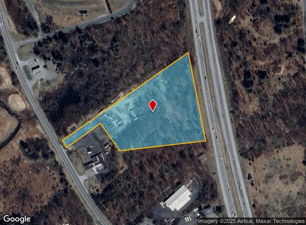
343 Bloomingburg Rd
New York-Jersey City-White Plains, NY-NJ
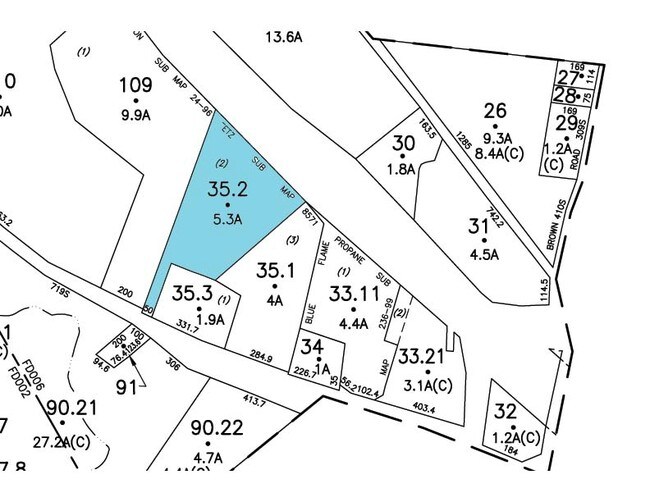
Tetz
335200-003-000-0001-035.200-0000
LT 2 TETZ SUB MAP 8571
Commercialacreage
Orange
X
New York
36111C0825E
35.20
2024
5.30 AC
2024
Middletown
015100
Northern New Jersey
DEMOGRAPHICS near 343 Bloomingburg Rd
1 Mile
3 Mile
5 Mile
2024 Total Population
859
6,563
40,431
2029 Population
878
6,745
41,072
Pop Growth 2024-2029
+ 2.21%
+ 2.77%
+ 1.59%
Average Age
43
39
40
2024 Total Households
280
2,119
14,401
HH Growth 2024-2029
+ 2.14%
+ 2.74%
+ 1.62%
Median Household Inc
$113,651
$96,422
$90,109
Avg Household Size
2.70
2.90
2.70
2024 Avg HH Vehicles
2.00
2.00
2.00
Median Home Value
$354,729
$340,625
$283,513
Median Year Built
1991
1983
1976
Nearby Places
Map Layers
Map Styles
 Street
 Aerial
- Restaurants
- Banks
- Shops
- Fitness
- Groceries
PUBLIC TRANSPORTATION
COMMUTER RAIL
Middletown New York (Bergen County/Port Jervis Line - NJ Transit Commuter Rail (NJ Transit), Main/Port Jervis Line - NJ Transit Commuter Rail (NJ Transit))
DRIVE
WALK
Distance
Middletown New York (Bergen County/Port Jervis Line - NJ Transit Commuter Rail (NJ Transit), Main/Port Jervis Line - NJ Transit Commuter Rail (NJ Transit))
10 min
5.8 mi
AIRPORT
New York Stewart International
DRIVE
WALK
Distance
New York Stewart International
31 min
23.5 mi
Freight Ports
Port Newark Container Terminal
DRIVE
WALK
Distance
Port Newark Container Terminal
95 min
74.8 mi
Nearby Properties
Address
Land Use
TOTAL SIZE
Lot Size
Zoning
Address
Land Use
TOTAL SIZE
Lot Size
Zoning
35.70 AC
R2
Address
Land Use
TOTAL SIZE
Lot Size
Zoning
20.90 AC
Address
Land Use
TOTAL SIZE
Lot Size
Zoning
2.35 AC
Address
Land Use
TOTAL SIZE
Lot Size
Zoning
17,135 SF
3.26 AC
Address
Land Use
TOTAL SIZE
Lot Size
Zoning
30,657 SF
135.40 AC
RA07
Address
Land Use
TOTAL SIZE
Lot Size
Zoning
57,942 SF
14.60 AC
R2
Address
Land Use
TOTAL SIZE
Lot Size
Zoning
12,920 SF
31 AC
RA
Address
Land Use
TOTAL SIZE
Lot Size
Zoning
Address
Land Use
TOTAL SIZE
Lot Size
Zoning
119,071 SF
29.10 AC
ENT-L
Address
Land Use
TOTAL SIZE
Lot Size
Zoning
26,508 SF
20.20 AC
O/R
Address
Land Use
TOTAL SIZE
Lot Size
Zoning
247.69 AC
RAG1
Address
Land Use
TOTAL SIZE
Lot Size
Zoning
1.41 AC
Address
Land Use
TOTAL SIZE
Lot Size
Zoning
4,978 SF
9.90 AC
ENT-L
Address
Land Use
TOTAL SIZE
Lot Size
Zoning
73.60 AC
07
Address
Land Use
TOTAL SIZE
Lot Size
Zoning
3,440 SF
1.16 AC
Address
Land Use
TOTAL SIZE
Lot Size
Zoning
1,624 SF
17.75 AC
Address
Land Use
TOTAL SIZE
Lot Size
Zoning
1,500 SF
56.20 AC
R1
Address
Land Use
TOTAL SIZE
Lot Size
Zoning
2,400 SF
25.30 AC
ENT-L
Address
Land Use
TOTAL SIZE
Lot Size
Zoning
29,588 SF
17.90 AC
ENT-L
Address
Land Use
TOTAL SIZE
Lot Size
Zoning
10.90 AC
Address
Land Use
TOTAL SIZE
Lot Size
Zoning
10,086 SF
0.29 AC
Address
Land Use
TOTAL SIZE
Lot Size
Zoning
80.80 AC
Address
Land Use
TOTAL SIZE
Lot Size
Zoning
20,000 SF
12.40 AC
O/R
Address
Land Use
TOTAL SIZE
Lot Size
Zoning
Address
Land Use
TOTAL SIZE
Lot Size
Zoning
8,382 SF
1.10 AC
Address
Land Use
TOTAL SIZE
Lot Size
Zoning
58.61 AC
RAG2
Address
Land Use
TOTAL SIZE
Lot Size
Zoning
1,870 SF
0.72 AC
Address
Land Use
TOTAL SIZE
Lot Size
Zoning
9,538 SF
1.90 AC
R2
Address
Land Use
TOTAL SIZE
Lot Size
Zoning
Address
Land Use
TOTAL SIZE
Lot Size
Zoning
16,000 SF
14.70 AC
RA07
The World's #1 Commercial Real Estate Marketplace
Connect with us
© 2025 CoStar Group
The information above has been obtained from sources believed reliable. While we do not doubt its accuracy we have not verified it and make no guarantee, warranty or representation about it. It is your responsibility to independently confirm its accuracy and completeness. Any projections, opinions, assumptions, or estimates used are for example only and do not represent the current or future performance of the property. The value of this transaction to you depends on tax and other factors which should be evaluated by your tax, financial, and legal advisors. You and your advisors should conduct a careful, independent investigation of the property to determine to your satisfaction the suitability of the property for your needs.