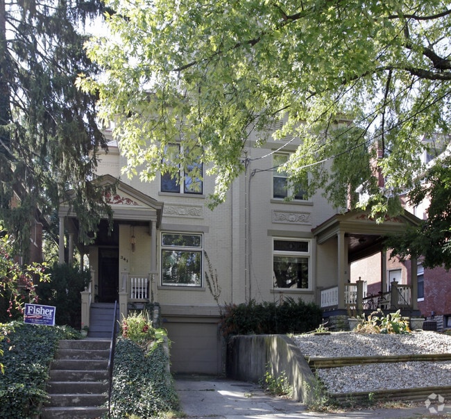
Property Record
343 Bryant Ave, Cincinnati, OH 45220


Property Detail
343 Bryant Ave
214-0004-0150
BRYANT AVE 25.67 X 125 IRR PT LOTS 41-42 JAS BRYANT
Apartment
Hamilton
SF6
Ohio
B and X Area of moderate flood hazard, usually the area between the limits of the 100-year and 500-year floods.
41-42
2025
0.07 AC
2025
Clifton
007100
Cincinnati/Dayton
3,396 SF
Cincinnati, OH-KY-IN
NEARBY LISTINGS FOR SALE OR LEASE
DEMOGRAPHICS near 343 Bryant Ave
1 mile
3 mile
5 mile
2025 Total Population
16,791
139,101
353,941
2030 Population
17,254
143,192
361,519
Pop Growth 2025-2030
+ 2.76%
+ 2.94%
+ 2.14%
Average Age
35
35
37
2025 Total Households
7,930
61,023
157,042
HH Growth 2025-2030
+ 2.74%
+ 3.09%
+ 2.26%
Median Household Inc
$50,227
$45,988
$55,253
Avg Household Size
1.90
2.00
2.10
2025 Avg HH Vehicles
1.00
1.00
1.00
Median Home Value
$396,544
$269,712
$230,372
Median Year Built
1950
1949
1949
Nearby Places
Map Layers
Map Styles
 Street
 Aerial
Layers
 Traffic
 Biking
Places
Listings with unknown addresses are not visible on the map
- Restaurants
- Banks
- Shops
- Fitness
- Groceries
PUBLIC TRANSPORTATION
COMMUTER RAIL
Cincinnati Union Terminal (Cardinal - Amtrak)
Drive
Walk
Distance
Cincinnati Union Terminal (Cardinal - Amtrak)
8 min
3.9 mi
AIRPORT
Cincinnati/Northern Kentucky International
Drive
Walk
Distance
Cincinnati/Northern Kentucky International
32 min
17.9 mi
Freight Ports
Port of Toledo
Drive
Walk
Distance
Port of Toledo
238 min
202.1 mi
Nearby Properties
Address
Land Use
TOTAL SIZE
Lot Size
Zoning
Address
Land Use
TOTAL SIZE
Lot Size
Zoning
77.73 AC
IR
Address
Land Use
TOTAL SIZE
Lot Size
Zoning
6.35 AC
IR
Address
Land Use
TOTAL SIZE
Lot Size
Zoning
11.82 AC
Address
Land Use
TOTAL SIZE
Lot Size
Zoning
11.62 AC
Address
Land Use
TOTAL SIZE
Lot Size
Zoning
19.36 AC
Address
Land Use
TOTAL SIZE
Lot Size
Zoning
62.10 AC
Address
Land Use
TOTAL SIZE
Lot Size
Zoning
11.41 AC
IR
Address
Land Use
TOTAL SIZE
Lot Size
Zoning
22.45 AC
Address
Land Use
TOTAL SIZE
Lot Size
Zoning
3.09 AC
Address
Land Use
TOTAL SIZE
Lot Size
Zoning
2.80 AC
IR
Address
Land Use
TOTAL SIZE
Lot Size
Zoning
3.40 AC
IR
Address
Land Use
TOTAL SIZE
Lot Size
Zoning
Address
Land Use
TOTAL SIZE
Lot Size
Zoning
3.51 AC
DD
Address
Land Use
TOTAL SIZE
Lot Size
Zoning
7.14 AC
Address
Land Use
TOTAL SIZE
Lot Size
Zoning
13.32 AC
Address
Land Use
TOTAL SIZE
Lot Size
Zoning
16.67 AC
IR
Address
Land Use
TOTAL SIZE
Lot Size
Zoning
9.38 AC
PR
Address
Land Use
TOTAL SIZE
Lot Size
Zoning
2.16 AC
DD
Address
Land Use
TOTAL SIZE
Lot Size
Zoning
3,184 SF
2.34 AC
IR
Address
Land Use
TOTAL SIZE
Lot Size
Zoning
Address
Land Use
TOTAL SIZE
Lot Size
Zoning
Address
Land Use
TOTAL SIZE
Lot Size
Zoning
Address
Land Use
TOTAL SIZE
Lot Size
Zoning
2.97 AC
IR
Address
Land Use
TOTAL SIZE
Lot Size
Zoning
29.60 AC
IR
Address
Land Use
TOTAL SIZE
Lot Size
Zoning
11.36 AC
IR
Address
Land Use
TOTAL SIZE
Lot Size
Zoning
3.27 AC
CCA
Address
Land Use
TOTAL SIZE
Lot Size
Zoning
0.37 AC
IR
Address
Land Use
TOTAL SIZE
Lot Size
Zoning
2.66 AC
DD
Address
Land Use
TOTAL SIZE
Lot Size
Zoning
Address
Land Use
TOTAL SIZE
Lot Size
Zoning
0.62 AC
The World's #1 Commercial Real Estate Marketplace
Connect with us
© 2026 CoStar Group
The information above has been obtained from sources believed reliable. While we do not doubt its accuracy we have not verified it and make no guarantee, warranty or representation about it. It is your responsibility to independently confirm its accuracy and completeness. Any projections, opinions, assumptions, or estimates used are for example only and do not represent the current or future performance of the property. The value of this transaction to you depends on tax and other factors which should be evaluated by your tax, financial, and legal advisors. You and your advisors should conduct a careful, independent investigation of the property to determine to your satisfaction the suitability of the property for your needs.