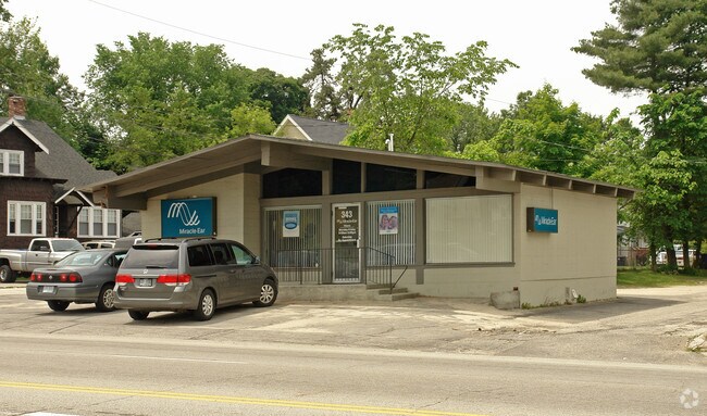
Property Record
343 Main St, Nashua, NH 03060

Save to a Folder
{{folder.Name}}
{{folder.ListingIds.length}} Properties
{{folder.ListingIds.length}} Property
Create a New Folder
Property Detail
343 Main St
NASH-000108-000000-000105
Hillsborough
Departmentstore
New Hampshire
D3MU
105
B and X Area of moderate flood hazard, usually the area between the limits of the 100-year and 500-year floods.
0.08 AC
2025
Hillsborough
2025
Boston
011000
Manchester-Nashua, NH
1,058 SF
NEARBY LISTINGS FOR SALE OR LEASE
DEMOGRAPHICS near 343 Main St
1 mile
3 mile
5 mile
2025 Total Population
20,445
85,179
123,498
2030 Population
20,620
86,128
125,151
Pop Growth 2025-2030
+ 0.86%
+ 1.11%
+ 1.34%
Average Age
39
42
42
2025 Total Households
8,460
35,047
50,725
HH Growth 2025-2030
+ 1.02%
+ 1.20%
+ 1.41%
Median Household Inc
$72,119
$97,669
$106,460
Avg Household Size
2.30
2.30
2.40
2025 Avg HH Vehicles
1.00
2.00
2.00
Median Home Value
$363,532
$417,464
$435,863
Median Year Built
1949
1971
1977
Nearby Places
Map Layers
Map Styles
 Street
 Aerial
Layers
 Traffic
 Biking
Places
Listings with unknown addresses are not visible on the map
- Restaurants
- Banks
- Shops
- Fitness
- Groceries
PUBLIC TRANSPORTATION
AIRPORT
Manchester Boston Regional
Drive
Walk
Distance
Manchester Boston Regional
28 min
15.7 mi
General Edward Lawrence Logan International
Drive
Walk
Distance
General Edward Lawrence Logan International
66 min
48.0 mi
SALE & LEASE HISTORY
LISTING DATE
SALE/LEASE

May 01, 2019
For Sale
Nearby Properties
Address
Land Use
TOTAL SIZE
Lot Size
Zoning
Address
Land Use
TOTAL SIZE
Lot Size
Zoning
19.70 AC
RB
Address
Land Use
TOTAL SIZE
Lot Size
Zoning
28.04 AC
PI
Address
Land Use
TOTAL SIZE
Lot Size
Zoning
29.77 AC
RC
Address
Land Use
TOTAL SIZE
Lot Size
Zoning
27.98 AC
GI
Address
Land Use
TOTAL SIZE
Lot Size
Zoning
20.72 AC
RC
Address
Land Use
TOTAL SIZE
Lot Size
Zoning
522,476 SF
74.89 AC
ID
Address
Land Use
TOTAL SIZE
Lot Size
Zoning
15.19 AC
RC
Address
Land Use
TOTAL SIZE
Lot Size
Zoning
60.25 AC
PI
Address
Land Use
TOTAL SIZE
Lot Size
Zoning
220,295 SF
4.34 AC
D1MU
Address
Land Use
TOTAL SIZE
Lot Size
Zoning
118.50 AC
PI
Address
Land Use
TOTAL SIZE
Lot Size
Zoning
20.80 AC
RC
Address
Land Use
TOTAL SIZE
Lot Size
Zoning
5.30 AC
GIMU
Address
Land Use
TOTAL SIZE
Lot Size
Zoning
133,390 SF
97.42 AC
B
Address
Land Use
TOTAL SIZE
Lot Size
Zoning
231,216 SF
1.88 AC
GIMU
Address
Land Use
TOTAL SIZE
Lot Size
Zoning
52.45 AC
R18
Address
Land Use
TOTAL SIZE
Lot Size
Zoning
2.77 AC
GIMU
Address
Land Use
TOTAL SIZE
Lot Size
Zoning
206,913 SF
18.30 AC
GB
Address
Land Use
TOTAL SIZE
Lot Size
Zoning
16.12 AC
RC
Address
Land Use
TOTAL SIZE
Lot Size
Zoning
21.40 AC
RC
Address
Land Use
TOTAL SIZE
Lot Size
Zoning
37.57 AC
R9
Address
Land Use
TOTAL SIZE
Lot Size
Zoning
8.87 AC
RC
Address
Land Use
TOTAL SIZE
Lot Size
Zoning
21.16 AC
D3MU
Address
Land Use
TOTAL SIZE
Lot Size
Zoning
74.50 AC
R9
Address
Land Use
TOTAL SIZE
Lot Size
Zoning
312,738 SF
25.84 AC
ID
Address
Land Use
TOTAL SIZE
Lot Size
Zoning
12.55 AC
RC
Address
Land Use
TOTAL SIZE
Lot Size
Zoning
33.81 AC
PI
Address
Land Use
TOTAL SIZE
Lot Size
Zoning
261,381 SF
3.78 AC
GIMU
Address
Land Use
TOTAL SIZE
Lot Size
Zoning
21.17 AC
RC
Address
Land Use
TOTAL SIZE
Lot Size
Zoning
185,242 SF
35.75 AC
ID
Address
Land Use
TOTAL SIZE
Lot Size
Zoning
8.09 AC
RC
The World's #1 Commercial Real Estate Marketplace
Connect with us
© 2026 CoStar Group
The information above has been obtained from sources believed reliable. While we do not doubt its accuracy we have not verified it and make no guarantee, warranty or representation about it. It is your responsibility to independently confirm its accuracy and completeness. Any projections, opinions, assumptions, or estimates used are for example only and do not represent the current or future performance of the property. The value of this transaction to you depends on tax and other factors which should be evaluated by your tax, financial, and legal advisors. You and your advisors should conduct a careful, independent investigation of the property to determine to your satisfaction the suitability of the property for your needs.