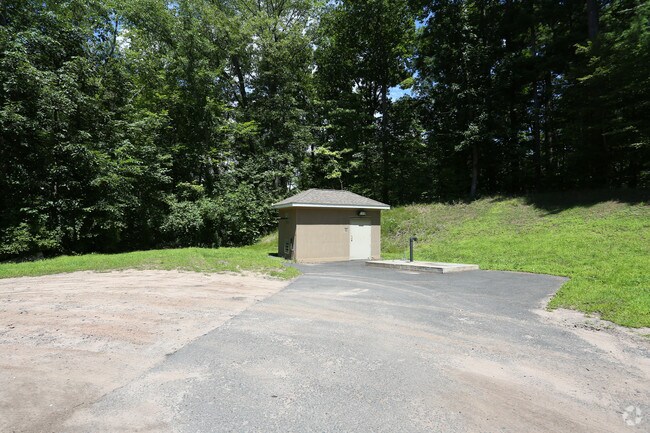
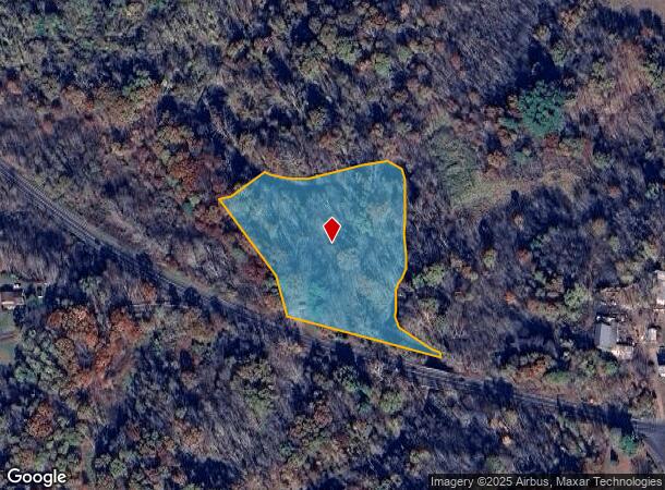
Property Record
343 North Rd, Broad Brook, CT 06016
NEARBY LISTINGS FOR SALE OR LEASE
Property Detail
343 North Rd
EWIN-000107-000036-000041
Hartford
Vacantlandnec
Connecticut
A
41
09003C0241F
2.81 AC
2025
East Windsor
2025
Hartford
484200
Hartford-West Hartford-East Hartford, CT
DEMOGRAPHICS near 343 North Rd
1 Mile
3 Mile
5 Mile
2024 Total Population
2,006
14,686
52,566
2029 Population
1,980
14,520
52,254
Pop Growth 2024-2029
(1.30%)
(1.13%)
(0.59%)
Average Age
43
44
43
2024 Total Households
862
6,014
21,882
HH Growth 2024-2029
(1.39%)
(1.21%)
(0.68%)
Median Household Inc
$88,664
$102,681
$93,262
Avg Household Size
2.20
2.40
2.30
2024 Avg HH Vehicles
2.00
2.00
2.00
Median Home Value
$239,729
$252,362
$253,549
Median Year Built
1975
1972
1971
Nearby Places
Map Layers
Map Styles
 Street
 Aerial
- Restaurants
- Banks
- Shops
- Fitness
- Groceries
PUBLIC TRANSPORTATION
COMMUTER RAIL
Windsor Locks (Hartford Line - CT Rail (CTRail))
DRIVE
WALK
Distance
Windsor Locks (Hartford Line - CT Rail (CTRail))
10 min
5.9 mi
AIRPORT
Bradley International
DRIVE
WALK
Distance
Bradley International
26 min
11.0 mi
Freight Ports
Port of New Haven
DRIVE
WALK
Distance
Port of New Haven
71 min
53.2 mi
SALE & LEASE HISTORY
LISTING DATE
SALE/LEASE

Jan 28, 2019
For Sale
Aug 10, 2018
For Sale
Nearby Properties
Address
Land Use
TOTAL SIZE
Lot Size
Zoning
Address
Land Use
TOTAL SIZE
Lot Size
Zoning
201,978 SF
53.95 AC
R88
Address
Land Use
TOTAL SIZE
Lot Size
Zoning
4,418 SF
106 AC
MFDD
Address
Land Use
TOTAL SIZE
Lot Size
Zoning
9,244 SF
46.83 AC
MFDD
Address
Land Use
TOTAL SIZE
Lot Size
Zoning
277,552 SF
40.24 AC
M-1
Address
Land Use
TOTAL SIZE
Lot Size
Zoning
117,699 SF
6.83 AC
MFDD
Address
Land Use
TOTAL SIZE
Lot Size
Zoning
75,238 SF
45.70 AC
R-1
Address
Land Use
TOTAL SIZE
Lot Size
Zoning
71,173 SF
14.30 AC
R-2
Address
Land Use
TOTAL SIZE
Lot Size
Zoning
273,865 SF
39.41 AC
M-1
Address
Land Use
TOTAL SIZE
Lot Size
Zoning
83,541 SF
16.30 AC
M-1
Address
Land Use
TOTAL SIZE
Lot Size
Zoning
11,000 SF
50.11 AC
B-3
Address
Land Use
TOTAL SIZE
Lot Size
Zoning
144,426 SF
14.44 AC
M-1
Address
Land Use
TOTAL SIZE
Lot Size
Zoning
121,455 SF
10 AC
M-1
Address
Land Use
TOTAL SIZE
Lot Size
Zoning
18.24 AC
R33
Address
Land Use
TOTAL SIZE
Lot Size
Zoning
4,066 SF
13.93 AC
ARHD
Address
Land Use
TOTAL SIZE
Lot Size
Zoning
59,184 SF
28.09 AC
B-1
Address
Land Use
TOTAL SIZE
Lot Size
Zoning
60,771 SF
11.55 AC
R33
Address
Land Use
TOTAL SIZE
Lot Size
Zoning
112,395 SF
7.06 AC
I-1
Address
Land Use
TOTAL SIZE
Lot Size
Zoning
279 AC
A-2
Address
Land Use
TOTAL SIZE
Lot Size
Zoning
48,750 SF
28 AC
R33
Address
Land Use
TOTAL SIZE
Lot Size
Zoning
38,394 SF
3.82 AC
B-1
Address
Land Use
TOTAL SIZE
Lot Size
Zoning
3,750 SF
53.53 AC
M-1
Address
Land Use
TOTAL SIZE
Lot Size
Zoning
28,309 SF
0.96 AC
B-2
Address
Land Use
TOTAL SIZE
Lot Size
Zoning
5,288 SF
1 AC
B-1
Address
Land Use
TOTAL SIZE
Lot Size
Zoning
132.39 AC
R-3
Address
Land Use
TOTAL SIZE
Lot Size
Zoning
69,450 SF
4.53 AC
M-1
Address
Land Use
TOTAL SIZE
Lot Size
Zoning
5.80 AC
R44
Address
Land Use
TOTAL SIZE
Lot Size
Zoning
15,940 SF
5.90 AC
B-2
Address
Land Use
TOTAL SIZE
Lot Size
Zoning
2,504 SF
43.69 AC
R-3
Address
Land Use
TOTAL SIZE
Lot Size
Zoning
52,956 SF
5.96 AC
R33
Address
Land Use
TOTAL SIZE
Lot Size
Zoning
35,700 SF
5.88 AC
B-2
The World's #1 Commercial Real Estate Marketplace
Connect with us
© 2026 CoStar Group
The information above has been obtained from sources believed reliable. While we do not doubt its accuracy we have not verified it and make no guarantee, warranty or representation about it. It is your responsibility to independently confirm its accuracy and completeness. Any projections, opinions, assumptions, or estimates used are for example only and do not represent the current or future performance of the property. The value of this transaction to you depends on tax and other factors which should be evaluated by your tax, financial, and legal advisors. You and your advisors should conduct a careful, independent investigation of the property to determine to your satisfaction the suitability of the property for your needs.