Property Record
3430 E Interstate Highway 10, San Antonio, TX 78220
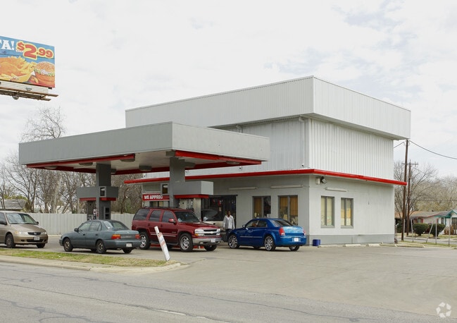

Property Detail
3430 E Interstate Highway 10
San Antonio-New Braunfels, TX
NCB 10269 BLK 10 LOT 47
10269-010-0470
BEXAR
Servicestation
Texas
B and X Area of moderate flood hazard, usually the area between the limits of the 100-year and 500-year floods.
47
2025
0.35 AC
2025
South
131100
San Antonio
25,887 SF
NEARBY LISTINGS FOR SALE OR LEASE
DEMOGRAPHICS near 3430 E Interstate Highway 10
1 mile
3 mile
5 mile
2025 Total Population
9,841
97,911
249,744
2030 Population
10,541
104,067
265,742
Pop Growth 2025-2030
+ 7.11%
+ 6.29%
+ 6.41%
Average Age
36
37
38
2025 Total Households
3,250
34,309
91,503
HH Growth 2025-2030
+ 7.38%
+ 6.36%
+ 6.75%
Median Household Inc
$35,449
$45,500
$52,404
Avg Household Size
2.90
2.70
2.50
2025 Avg HH Vehicles
2.00
2.00
2.00
Median Home Value
$99,268
$174,084
$204,321
Median Year Built
1965
1962
1969
Nearby Places
Map Layers
Map Styles
 Street
 Aerial
Layers
 Traffic
 Biking
Places
Listings with unknown addresses are not visible on the map
- Restaurants
- Banks
- Shops
- Fitness
- Groceries
PUBLIC TRANSPORTATION
COMMUTER RAIL
Drive
Walk
Distance
7 min
3.4 mi
AIRPORT
San Antonio International
Drive
Walk
Distance
San Antonio International
17 min
11.3 mi
Nearby Properties
Address
Land Use
TOTAL SIZE
Lot Size
Zoning
Address
Land Use
TOTAL SIZE
Lot Size
Zoning
2,544.56 AC
Address
Land Use
TOTAL SIZE
Lot Size
Zoning
397,806 SF
15.08 AC
Address
Land Use
TOTAL SIZE
Lot Size
Zoning
359,459 SF
15.81 AC
Address
Land Use
TOTAL SIZE
Lot Size
Zoning
202,609 SF
3.25 AC
Address
Land Use
TOTAL SIZE
Lot Size
Zoning
71,253 SF
25.52 AC
Address
Land Use
TOTAL SIZE
Lot Size
Zoning
35.76 AC
Address
Land Use
TOTAL SIZE
Lot Size
Zoning
273,370 SF
11.93 AC
Address
Land Use
TOTAL SIZE
Lot Size
Zoning
139,410 SF
35.75 AC
Address
Land Use
TOTAL SIZE
Lot Size
Zoning
110,252 SF
20.04 AC
Address
Land Use
TOTAL SIZE
Lot Size
Zoning
88,420 SF
7.62 AC
Address
Land Use
TOTAL SIZE
Lot Size
Zoning
300,987 SF
29.07 AC
Address
Land Use
TOTAL SIZE
Lot Size
Zoning
33.77 AC
Address
Land Use
TOTAL SIZE
Lot Size
Zoning
208,494 SF
9.63 AC
Address
Land Use
TOTAL SIZE
Lot Size
Zoning
145,389 SF
18.70 AC
Address
Land Use
TOTAL SIZE
Lot Size
Zoning
221,760 SF
7.22 AC
Address
Land Use
TOTAL SIZE
Lot Size
Zoning
187,369 SF
2.72 AC
Address
Land Use
TOTAL SIZE
Lot Size
Zoning
25,164 SF
13.31 AC
Address
Land Use
TOTAL SIZE
Lot Size
Zoning
101,517 SF
13.04 AC
Address
Land Use
TOTAL SIZE
Lot Size
Zoning
362,280 SF
17.84 AC
Address
Land Use
TOTAL SIZE
Lot Size
Zoning
332,148 SF
17.75 AC
Address
Land Use
TOTAL SIZE
Lot Size
Zoning
68,055 SF
18.06 AC
Address
Land Use
TOTAL SIZE
Lot Size
Zoning
99.85 AC
Address
Land Use
TOTAL SIZE
Lot Size
Zoning
144,692 SF
10.83 AC
Address
Land Use
TOTAL SIZE
Lot Size
Zoning
341,546 SF
26.84 AC
Address
Land Use
TOTAL SIZE
Lot Size
Zoning
201,672 SF
12.48 AC
Address
Land Use
TOTAL SIZE
Lot Size
Zoning
44,800 SF
61.44 AC
Address
Land Use
TOTAL SIZE
Lot Size
Zoning
64,043 SF
14.96 AC
Address
Land Use
TOTAL SIZE
Lot Size
Zoning
213,984 SF
10.63 AC
Address
Land Use
TOTAL SIZE
Lot Size
Zoning
225,564 SF
15.62 AC
Address
Land Use
TOTAL SIZE
Lot Size
Zoning
233,361 SF
9.65 AC
The World's #1 Commercial Real Estate Marketplace
Connect with us
© 2026 CoStar Group
The information above has been obtained from sources believed reliable. While we do not doubt its accuracy we have not verified it and make no guarantee, warranty or representation about it. It is your responsibility to independently confirm its accuracy and completeness. Any projections, opinions, assumptions, or estimates used are for example only and do not represent the current or future performance of the property. The value of this transaction to you depends on tax and other factors which should be evaluated by your tax, financial, and legal advisors. You and your advisors should conduct a careful, independent investigation of the property to determine to your satisfaction the suitability of the property for your needs.