Property Record
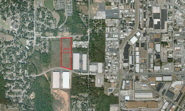
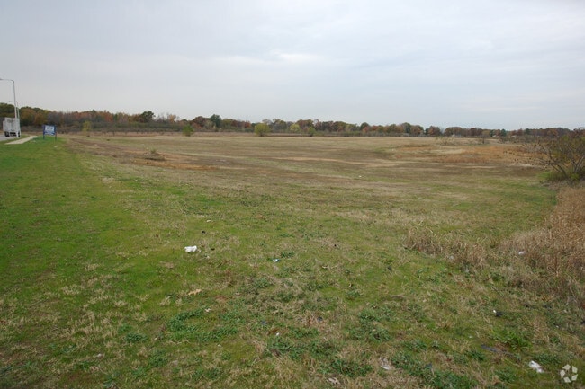
3430 E Raines Rd, Memphis, TN 38118

Property Detail
3430 E Raines Rd
07-3088-0-0203C
NS RAINES ROAD TO SS CHRISTINE ROAD SEE MAP 196F
Truckterminal
Shelby
CMU-2
Tennessee
B and X Area of moderate flood hazard, usually the area between the limits of the 100-year and 500-year floods.
60.70 AC
0
Airport
2025
Memphis
011020
Memphis, TN-MS-AR
118,116 SF
NEARBY LISTINGS FOR SALE OR LEASE
DEMOGRAPHICS near 3430 E Raines Rd
1 mile
3 mile
5 mile
2025 Total Population
5,451
37,925
164,944
2030 Population
5,597
38,150
164,934
Pop Growth 2025-2030
+ 2.68%
+ 0.59%
(0.01%)
Average Age
36
34
36
2025 Total Households
2,034
13,451
62,331
HH Growth 2025-2030
+ 3.10%
+ 0.76%
(0.07%)
Median Household Inc
$48,879
$43,845
$46,212
Avg Household Size
2.60
2.80
2.60
2025 Avg HH Vehicles
2.00
2.00
2.00
Median Home Value
$133,333
$126,735
$155,056
Median Year Built
1972
1972
1967
Nearby Places
Map Layers
Map Styles
 Street
 Aerial
Layers
 Traffic
 Biking
Places
Listings with unknown addresses are not visible on the map
- Restaurants
- Banks
- Shops
- Fitness
- Groceries
PUBLIC TRANSPORTATION
AIRPORT
Memphis International
Drive
Walk
Distance
Memphis International
13 min
4.2 mi
Nearby Properties
Address
Land Use
TOTAL SIZE
Lot Size
Zoning
Address
Land Use
TOTAL SIZE
Lot Size
Zoning
986,374 SF
68.79 AC
CA
Address
Land Use
TOTAL SIZE
Lot Size
Zoning
969,150 SF
64.49 AC
EMP
Address
Land Use
TOTAL SIZE
Lot Size
Zoning
717,155 SF
83.34 AC
CA
Address
Land Use
TOTAL SIZE
Lot Size
Zoning
838,318 SF
39.56 AC
I-L
Address
Land Use
TOTAL SIZE
Lot Size
Zoning
237,911 SF
21.38 AC
EMP
Address
Land Use
TOTAL SIZE
Lot Size
Zoning
571,642 SF
23.56 AC
EMP
Address
Land Use
TOTAL SIZE
Lot Size
Zoning
180,831 SF
13.11 AC
EMP
Address
Land Use
TOTAL SIZE
Lot Size
Zoning
1,034,433 SF
53.32 AC
EMP
Address
Land Use
TOTAL SIZE
Lot Size
Zoning
861,322 SF
72.92 AC
CA
Address
Land Use
TOTAL SIZE
Lot Size
Zoning
279,419 SF
172.07 AC
EMP
Address
Land Use
TOTAL SIZE
Lot Size
Zoning
357,582 SF
5.61 AC
EMP
Address
Land Use
TOTAL SIZE
Lot Size
Zoning
328,300 SF
33.78 AC
CA
Address
Land Use
TOTAL SIZE
Lot Size
Zoning
321.59 AC
R-8
Address
Land Use
TOTAL SIZE
Lot Size
Zoning
739,205 SF
31.51 AC
AG
Address
Land Use
TOTAL SIZE
Lot Size
Zoning
265,600 SF
22.03 AC
CA
Address
Land Use
TOTAL SIZE
Lot Size
Zoning
2,847.82 AC
EMP
Address
Land Use
TOTAL SIZE
Lot Size
Zoning
188,458 SF
29.19 AC
RU-3
Address
Land Use
TOTAL SIZE
Lot Size
Zoning
605,539 SF
28.59 AC
RU-1
Address
Land Use
TOTAL SIZE
Lot Size
Zoning
47.65 AC
R-8
Address
Land Use
TOTAL SIZE
Lot Size
Zoning
618,133 SF
37.58 AC
EMP
Address
Land Use
TOTAL SIZE
Lot Size
Zoning
508,104 SF
36.83 AC
EMP
Address
Land Use
TOTAL SIZE
Lot Size
Zoning
585,535 SF
31.96 AC
EMP
Address
Land Use
TOTAL SIZE
Lot Size
Zoning
457,681 SF
21.02 AC
EMP
Address
Land Use
TOTAL SIZE
Lot Size
Zoning
63,842 SF
11 AC
R-6
Address
Land Use
TOTAL SIZE
Lot Size
Zoning
1,137,460 SF
62.54 AC
IH
Address
Land Use
TOTAL SIZE
Lot Size
Zoning
81,454 SF
EMP
Address
Land Use
TOTAL SIZE
Lot Size
Zoning
58.21 AC
R-6
Address
Land Use
TOTAL SIZE
Lot Size
Zoning
532,073 SF
20.99 AC
EMP
Address
Land Use
TOTAL SIZE
Lot Size
Zoning
509,111 SF
EMP
The World's #1 Commercial Real Estate Marketplace
Connect with us
© 2026 CoStar Group
The information above has been obtained from sources believed reliable. While we do not doubt its accuracy we have not verified it and make no guarantee, warranty or representation about it. It is your responsibility to independently confirm its accuracy and completeness. Any projections, opinions, assumptions, or estimates used are for example only and do not represent the current or future performance of the property. The value of this transaction to you depends on tax and other factors which should be evaluated by your tax, financial, and legal advisors. You and your advisors should conduct a careful, independent investigation of the property to determine to your satisfaction the suitability of the property for your needs.