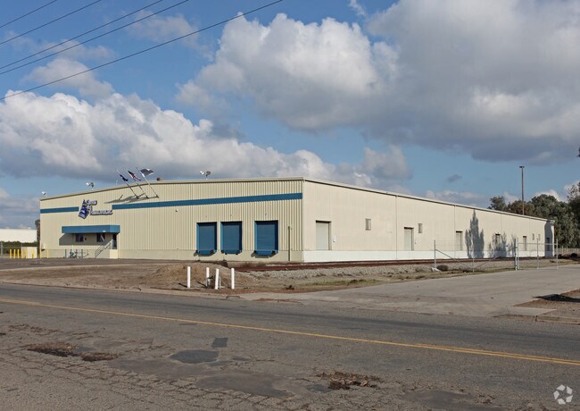
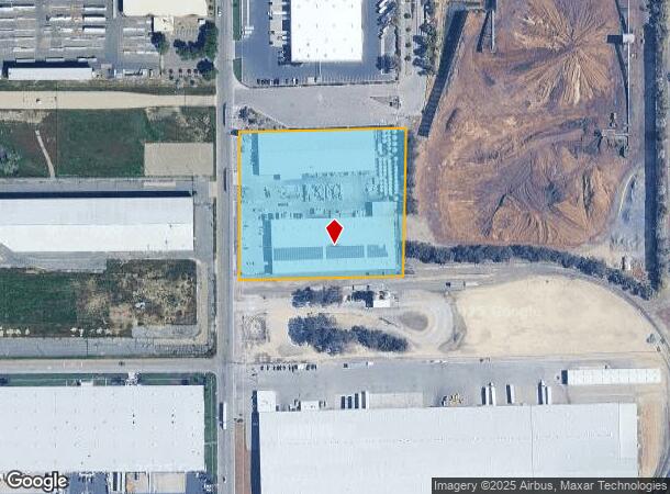
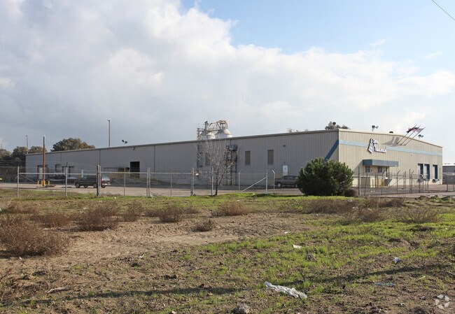
Property Record
3430 S Willow Ave, Fresno, CA 93725

NEARBY LISTINGS FOR SALE OR LEASE
Property Detail
3430 S Willow Ave
331-072-06
Malaga Prcl A
Lightindustrial
4.58 AC PAR A MAP 1927 BK 11 PG 64 MALAGA TR
X
Fresno
06019C2140H
California
2025
4.58 AC
2025
Southeast Fresno
001500
Fresno
92,100 SF
Fresno, CA
DEMOGRAPHICS near 3430 S Willow Ave
1 Mile
3 Mile
5 Mile
2024 Total Population
1,257
38,938
156,690
2029 Population
1,244
39,557
159,696
Pop Growth 2024-2029
(1.03%)
+ 1.59%
+ 1.92%
Average Age
37
34
34
2024 Total Households
321
10,507
43,085
HH Growth 2024-2029
(1.25%)
+ 1.66%
+ 1.96%
Median Household Inc
$60,682
$60,765
$51,045
Avg Household Size
3.60
3.60
3.50
2024 Avg HH Vehicles
2.00
2.00
2.00
Median Home Value
$324,468
$294,535
$283,821
Median Year Built
1973
1985
1975
Nearby Places
Map Layers
Map Styles
 Street
 Aerial
- Restaurants
- Banks
- Shops
- Fitness
- Groceries
PUBLIC TRANSPORTATION
COMMUTER RAIL
Fresno (San Joaquins - Amtrak)
DRIVE
WALK
Distance
Fresno (San Joaquins - Amtrak)
12 min
6.8 mi
AIRPORT
Fresno Yosemite International
DRIVE
WALK
Distance
Fresno Yosemite International
14 min
6.7 mi
Freight Ports
Port of Stockton
DRIVE
WALK
Distance
Port of Stockton
159 min
133.3 mi
Nearby Properties
Address
Land Use
TOTAL SIZE
Lot Size
Zoning
Address
Land Use
TOTAL SIZE
Lot Size
Zoning
855,000 SF
63.99 AC
IH
Address
Land Use
TOTAL SIZE
Lot Size
Zoning
660,486 SF
39.04 AC
M3
Address
Land Use
TOTAL SIZE
Lot Size
Zoning
176,926 SF
9.79 AC
IH
Address
Land Use
TOTAL SIZE
Lot Size
Zoning
732,149 SF
77.34 AC
M3
Address
Land Use
TOTAL SIZE
Lot Size
Zoning
291,527 SF
28.85 AC
M3
Address
Land Use
TOTAL SIZE
Lot Size
Zoning
670,680 SF
30.16 AC
IH
Address
Land Use
TOTAL SIZE
Lot Size
Zoning
50,450 SF
16.84 AC
M3
Address
Land Use
TOTAL SIZE
Lot Size
Zoning
343,038 SF
19.54 AC
AE20
Address
Land Use
TOTAL SIZE
Lot Size
Zoning
193,440 SF
16.82 AC
Address
Land Use
TOTAL SIZE
Lot Size
Zoning
116,349 SF
16.56 AC
CP
Address
Land Use
TOTAL SIZE
Lot Size
Zoning
396,353 SF
34.78 AC
M3
Address
Land Use
TOTAL SIZE
Lot Size
Zoning
511,500 SF
22.55 AC
M3
Address
Land Use
TOTAL SIZE
Lot Size
Zoning
12,088 SF
23.62 AC
M3
Address
Land Use
TOTAL SIZE
Lot Size
Zoning
198,436 SF
20.85 AC
M3
Address
Land Use
TOTAL SIZE
Lot Size
Zoning
84,376 SF
20 AC
AE20
Address
Land Use
TOTAL SIZE
Lot Size
Zoning
54,526 SF
5.88 AC
M3
Address
Land Use
TOTAL SIZE
Lot Size
Zoning
55,200 SF
14.94 AC
M3
Address
Land Use
TOTAL SIZE
Lot Size
Zoning
410,925 SF
18.77 AC
M3
Address
Land Use
TOTAL SIZE
Lot Size
Zoning
319,790 SF
41.15 AC
R1
Address
Land Use
TOTAL SIZE
Lot Size
Zoning
104,036 SF
6.73 AC
M3
Address
Land Use
TOTAL SIZE
Lot Size
Zoning
514,976 SF
24.18 AC
M3
Address
Land Use
TOTAL SIZE
Lot Size
Zoning
202,038 SF
10.83 AC
IH
Address
Land Use
TOTAL SIZE
Lot Size
Zoning
269,290 SF
12.36 AC
IL
Address
Land Use
TOTAL SIZE
Lot Size
Zoning
524,298 SF
22.08 AC
M3
Address
Land Use
TOTAL SIZE
Lot Size
Zoning
267,104 SF
64.16 AC
M3
Address
Land Use
TOTAL SIZE
Lot Size
Zoning
26,978 SF
2.25 AC
Address
Land Use
TOTAL SIZE
Lot Size
Zoning
147,840 SF
8.55 AC
M3
Address
Land Use
TOTAL SIZE
Lot Size
Zoning
100,800 SF
5.16 AC
Address
Land Use
TOTAL SIZE
Lot Size
Zoning
108,512 SF
9.92 AC
R2
The World's #1 Commercial Real Estate Marketplace
Connect with us
© 2025 CoStar Group
The information above has been obtained from sources believed reliable. While we do not doubt its accuracy we have not verified it and make no guarantee, warranty or representation about it. It is your responsibility to independently confirm its accuracy and completeness. Any projections, opinions, assumptions, or estimates used are for example only and do not represent the current or future performance of the property. The value of this transaction to you depends on tax and other factors which should be evaluated by your tax, financial, and legal advisors. You and your advisors should conduct a careful, independent investigation of the property to determine to your satisfaction the suitability of the property for your needs.