Property Record
3431 Oakdale St, San Antonio, TX 78229

NEARBY LISTINGS FOR SALE OR LEASE
-
-
View all San Antonio listings for sale on LoopNet.com
Property Detail
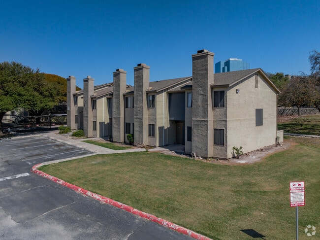
3431 Oakdale St
San Antonio-New Braunfels, TX
Oaklawn Sub Bl 13301 Un 4
13301-002-0010
NCB 13302 BLK 3 LOT 1
Multifamilydwelling
Bexar
X
Texas
48029C0245G
1
2024
7.64 AC
2025
Lafayette Place
181005
San Antonio
171,586 SF
DEMOGRAPHICS near 3431 Oakdale St
1 Mile
3 Mile
5 Mile
2024 Total Population
17,132
153,973
377,292
2029 Population
18,192
163,786
400,910
Pop Growth 2024-2029
+ 6.19%
+ 6.37%
+ 6.26%
Average Age
37
37
38
2024 Total Households
7,736
65,559
156,193
HH Growth 2024-2029
+ 6.48%
+ 6.70%
+ 6.55%
Median Household Inc
$40,894
$45,300
$49,302
Avg Household Size
2.20
2.30
2.30
2024 Avg HH Vehicles
1.00
1.00
2.00
Median Home Value
$174,387
$186,865
$196,101
Median Year Built
1973
1975
1977
Nearby Places
Map Layers
Map Styles
 Street
 Aerial
- Restaurants
- Banks
- Shops
- Fitness
- Groceries
PUBLIC TRANSPORTATION
COMMUTER RAIL
San Antonio Amtrak Station (Sunset Limited - Amtrak, Texas Eagle - Amtrak)
DRIVE
WALK
Distance
San Antonio Amtrak Station (Sunset Limited - Amtrak, Texas Eagle - Amtrak)
16 min
9.4 mi
AIRPORT
San Antonio International
DRIVE
WALK
Distance
San Antonio International
10 min
6.5 mi
Freight Ports
Calhoun Port
DRIVE
WALK
Distance
Calhoun Port
192 min
156.8 mi
Nearby Properties
Address
Land Use
TOTAL SIZE
Lot Size
Zoning
Address
Land Use
TOTAL SIZE
Lot Size
Zoning
1,414,945 SF
16.77 AC
Address
Land Use
TOTAL SIZE
Lot Size
Zoning
609,267 SF
30.47 AC
Address
Land Use
TOTAL SIZE
Lot Size
Zoning
429,561 SF
25.70 AC
Address
Land Use
TOTAL SIZE
Lot Size
Zoning
97.47 AC
Address
Land Use
TOTAL SIZE
Lot Size
Zoning
278,352 SF
10 AC
Address
Land Use
TOTAL SIZE
Lot Size
Zoning
306,959 SF
15.24 AC
Address
Land Use
TOTAL SIZE
Lot Size
Zoning
482,412 SF
22.97 AC
Address
Land Use
TOTAL SIZE
Lot Size
Zoning
227,744 SF
3.99 AC
Address
Land Use
TOTAL SIZE
Lot Size
Zoning
239,623 SF
26.63 AC
Address
Land Use
TOTAL SIZE
Lot Size
Zoning
506,058 SF
25.23 AC
Address
Land Use
TOTAL SIZE
Lot Size
Zoning
201,339 SF
9.32 AC
Address
Land Use
TOTAL SIZE
Lot Size
Zoning
288,719 SF
14.66 AC
Address
Land Use
TOTAL SIZE
Lot Size
Zoning
495,484 SF
5.81 AC
Address
Land Use
TOTAL SIZE
Lot Size
Zoning
61.64 AC
Address
Land Use
TOTAL SIZE
Lot Size
Zoning
305,379 SF
12.04 AC
Address
Land Use
TOTAL SIZE
Lot Size
Zoning
259,934 SF
9.81 AC
Address
Land Use
TOTAL SIZE
Lot Size
Zoning
211,045 SF
8.08 AC
Address
Land Use
TOTAL SIZE
Lot Size
Zoning
8,508 SF
3.34 AC
Address
Land Use
TOTAL SIZE
Lot Size
Zoning
221,778 SF
16.31 AC
Address
Land Use
TOTAL SIZE
Lot Size
Zoning
63.25 AC
Address
Land Use
TOTAL SIZE
Lot Size
Zoning
299,088 SF
15.66 AC
Address
Land Use
TOTAL SIZE
Lot Size
Zoning
232,398 SF
12.66 AC
Address
Land Use
TOTAL SIZE
Lot Size
Zoning
211,182 SF
6.73 AC
Address
Land Use
TOTAL SIZE
Lot Size
Zoning
210,731 SF
14.15 AC
Address
Land Use
TOTAL SIZE
Lot Size
Zoning
291,385 SF
16.19 AC
Address
Land Use
TOTAL SIZE
Lot Size
Zoning
137,036 SF
4.73 AC
Address
Land Use
TOTAL SIZE
Lot Size
Zoning
356,368 SF
18.58 AC
Address
Land Use
TOTAL SIZE
Lot Size
Zoning
122,292 SF
12.83 AC
Address
Land Use
TOTAL SIZE
Lot Size
Zoning
293,420 SF
9.24 AC
Address
Land Use
TOTAL SIZE
Lot Size
Zoning
256,678 SF
4.42 AC
The World's #1 Commercial Real Estate Marketplace
Connect with us
© 2026 CoStar Group
The information above has been obtained from sources believed reliable. While we do not doubt its accuracy we have not verified it and make no guarantee, warranty or representation about it. It is your responsibility to independently confirm its accuracy and completeness. Any projections, opinions, assumptions, or estimates used are for example only and do not represent the current or future performance of the property. The value of this transaction to you depends on tax and other factors which should be evaluated by your tax, financial, and legal advisors. You and your advisors should conduct a careful, independent investigation of the property to determine to your satisfaction the suitability of the property for your needs.