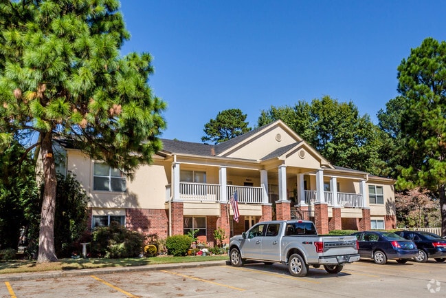
Property Record
3434 E Kiehl Ave, Sherwood, AR 72120


NEARBY LISTINGS FOR SALE OR LEASE
-
-
View all Sherwood listings for sale on LoopNet.com
Property Detail
3434 E Kiehl Ave
Little Rock-North Little Rock-Conway, AR
Greens Apartment Addn
23S-003-14-001-00
BEING A REPLAT OF LT 1 & ADDITIONAL LANDS NOW REPLATTED AS LT 1R
Nightclub
Pulaski
AE
Arkansas
05119C0354G
1
2025
42.55 AC
2025
Jacksonville/Sherwood
003704
Little Rock/N Little Rock
17,352 SF
DEMOGRAPHICS near 3434 E Kiehl Ave
1 Mile
3 Mile
5 Mile
2024 Total Population
7,322
39,335
80,242
2029 Population
7,278
39,087
79,913
Pop Growth 2024-2029
(0.60%)
(0.63%)
(0.41%)
Average Age
38
41
40
2024 Total Households
3,121
16,588
33,811
HH Growth 2024-2029
(0.64%)
(0.71%)
(0.41%)
Median Household Inc
$53,559
$70,154
$58,726
Avg Household Size
2.30
2.30
2.30
2024 Avg HH Vehicles
2.00
2.00
2.00
Median Home Value
$188,525
$184,680
$173,796
Median Year Built
1986
1984
1979
Nearby Places
Map Layers
Map Styles
 Street
 Aerial
- Restaurants
- Banks
- Shops
- Fitness
- Groceries
PUBLIC TRANSPORTATION
COMMUTER RAIL
Little Rock Union Station (Texas Eagle - Amtrak)
DRIVE
WALK
Distance
Little Rock Union Station (Texas Eagle - Amtrak)
14 min
9.4 mi
AIRPORT
Bill and Hillary Clinton Ntl/Adams Field
DRIVE
WALK
Distance
Bill and Hillary Clinton Ntl/Adams Field
19 min
13.0 mi
Freight Ports
Port of Shreveport
DRIVE
WALK
Distance
Port of Shreveport
261 min
241.9 mi
Nearby Properties
Address
Land Use
TOTAL SIZE
Lot Size
Zoning
Address
Land Use
TOTAL SIZE
Lot Size
Zoning
316,927 SF
50.65 AC
Address
Land Use
TOTAL SIZE
Lot Size
Zoning
82,978 SF
12.54 AC
Address
Land Use
TOTAL SIZE
Lot Size
Zoning
72,806 SF
10.95 AC
Address
Land Use
TOTAL SIZE
Lot Size
Zoning
38,202 SF
14.23 AC
Address
Land Use
TOTAL SIZE
Lot Size
Zoning
36,934 SF
15.06 AC
Address
Land Use
TOTAL SIZE
Lot Size
Zoning
75,462 SF
5.33 AC
Address
Land Use
TOTAL SIZE
Lot Size
Zoning
219,330 SF
24.14 AC
Address
Land Use
TOTAL SIZE
Lot Size
Zoning
83,431 SF
10.99 AC
Address
Land Use
TOTAL SIZE
Lot Size
Zoning
49,995 SF
12.92 AC
Address
Land Use
TOTAL SIZE
Lot Size
Zoning
72,157 SF
9.45 AC
Address
Land Use
TOTAL SIZE
Lot Size
Zoning
31,644 SF
Address
Land Use
TOTAL SIZE
Lot Size
Zoning
56,643 SF
9.46 AC
Address
Land Use
TOTAL SIZE
Lot Size
Zoning
62,316 SF
6.23 AC
Address
Land Use
TOTAL SIZE
Lot Size
Zoning
28,947 SF
8.29 AC
Address
Land Use
TOTAL SIZE
Lot Size
Zoning
105,516 SF
9.31 AC
Address
Land Use
TOTAL SIZE
Lot Size
Zoning
60,539 SF
2.95 AC
Address
Land Use
TOTAL SIZE
Lot Size
Zoning
8,520 SF
11.30 AC
Address
Land Use
TOTAL SIZE
Lot Size
Zoning
39,513 SF
Address
Land Use
TOTAL SIZE
Lot Size
Zoning
45,500 SF
12.07 AC
Address
Land Use
TOTAL SIZE
Lot Size
Zoning
100,163 SF
15.51 AC
Address
Land Use
TOTAL SIZE
Lot Size
Zoning
111,425 SF
1.69 AC
Address
Land Use
TOTAL SIZE
Lot Size
Zoning
145,604 SF
12.62 AC
Address
Land Use
TOTAL SIZE
Lot Size
Zoning
32,788 SF
3.99 AC
Address
Land Use
TOTAL SIZE
Lot Size
Zoning
33,597 SF
Address
Land Use
TOTAL SIZE
Lot Size
Zoning
141,664 SF
12.21 AC
Address
Land Use
TOTAL SIZE
Lot Size
Zoning
44,092 SF
7.97 AC
Address
Land Use
TOTAL SIZE
Lot Size
Zoning
3,306 SF
8.33 AC
Address
Land Use
TOTAL SIZE
Lot Size
Zoning
54,401 SF
1.68 AC
Address
Land Use
TOTAL SIZE
Lot Size
Zoning
40,065 SF
8.26 AC
The World's #1 Commercial Real Estate Marketplace
Connect with us
© 2026 CoStar Group
The information above has been obtained from sources believed reliable. While we do not doubt its accuracy we have not verified it and make no guarantee, warranty or representation about it. It is your responsibility to independently confirm its accuracy and completeness. Any projections, opinions, assumptions, or estimates used are for example only and do not represent the current or future performance of the property. The value of this transaction to you depends on tax and other factors which should be evaluated by your tax, financial, and legal advisors. You and your advisors should conduct a careful, independent investigation of the property to determine to your satisfaction the suitability of the property for your needs.