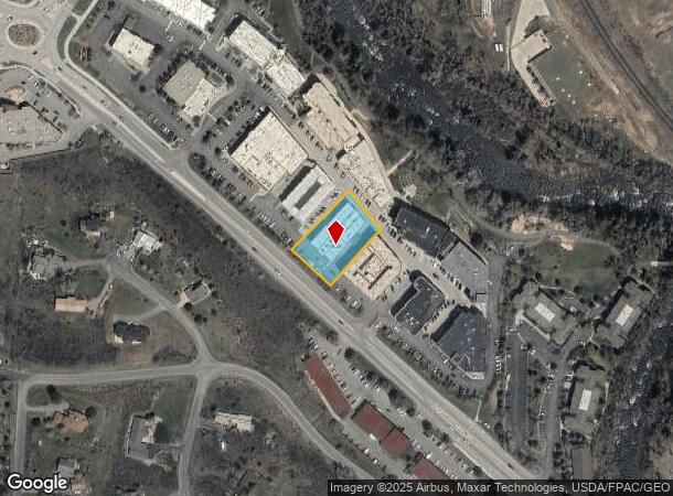
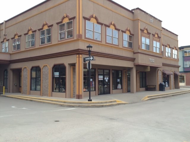
Property Record
34353 Highway 6, Edwards, CO 81632

Property Detail
34353 Highway 6
R045488
Riverwalk Topaz Building Condos
Condominium
SUBDIVISION: RIVERWALK TOPAZ BUILDING CONDOS UNIT: R-203 BK-0727 PG-0842 MAP 05-28-97 BK-0727 PG-0843 DEC 05-28-97 BK-0736 PG-0441 DEC 09-08-97 R801252 DEC 07-11-02 R807415 DEC 09-17-02 R807416 MAP 09-17-02
X
Eagle
08037C0439D
Colorado
2024
0.03 AC
2025
Colorado Ski Area
000401
Other Market Areas
899 SF
Edwards, CO
NEARBY LISTINGS FOR SALE OR LEASE
DEMOGRAPHICS near 34353 Highway 6
1 mile
3 mile
5 mile
2024 Total Population
3,839
10,650
15,861
2029 Population
3,656
10,172
15,190
Pop Growth 2024-2029
(4.77%)
(4.49%)
(4.23%)
Average Age
40
39
38
2024 Total Households
1,469
3,854
5,753
HH Growth 2024-2029
(5.65%)
(5.50%)
(5.23%)
Median Household Inc
$109,279
$84,669
$85,798
Avg Household Size
2.50
2.60
2.60
2024 Avg HH Vehicles
2.00
2.00
2.00
Median Home Value
$759,042
$862,149
$857,471
Median Year Built
1996
1994
1993
Nearby Places
Map Layers
Map Styles
 Street
 Aerial
Transit
 Traffic
 Biking
Places
Listings with unknown addresses are not visible on the map
- Restaurants
- Banks
- Shops
- Fitness
- Groceries
PUBLIC TRANSPORTATION
AIRPORT
Eagle County Regional
Drive
Walk
Distance
Eagle County Regional
29 min
22.9 mi
Freight Ports
Tulsa Port Of Catoosa
Drive
Walk
Distance
Tulsa Port Of Catoosa
859 min
819.5 mi
SALE & LEASE HISTORY
LISTING DATE
SALE/LEASE

Sep 19, 2024
For Lease
May 17, 2017
For Lease
Aug 12, 2025
For Lease
Nearby Properties
Address
Land Use
TOTAL SIZE
Lot Size
Zoning
Address
Land Use
TOTAL SIZE
Lot Size
Zoning
201,683 SF
1.75 AC
Address
Land Use
TOTAL SIZE
Lot Size
Zoning
89,878 SF
8.74 AC
Address
Land Use
TOTAL SIZE
Lot Size
Zoning
98,807 SF
7.15 AC
Address
Land Use
TOTAL SIZE
Lot Size
Zoning
90,445 SF
4.87 AC
Address
Land Use
TOTAL SIZE
Lot Size
Zoning
10,816 SF
38.75 AC
Address
Land Use
TOTAL SIZE
Lot Size
Zoning
352,335 SF
29.96 AC
Address
Land Use
TOTAL SIZE
Lot Size
Zoning
71,083 SF
7.28 AC
Address
Land Use
TOTAL SIZE
Lot Size
Zoning
98,493 SF
2.51 AC
Address
Land Use
TOTAL SIZE
Lot Size
Zoning
65,400 SF
1.87 AC
Address
Land Use
TOTAL SIZE
Lot Size
Zoning
16.77 AC
Address
Land Use
TOTAL SIZE
Lot Size
Zoning
49,228 SF
9.88 AC
Address
Land Use
TOTAL SIZE
Lot Size
Zoning
3,306 SF
14.94 AC
Address
Land Use
TOTAL SIZE
Lot Size
Zoning
146,951 SF
5.73 AC
Address
Land Use
TOTAL SIZE
Lot Size
Zoning
15,328 SF
2.76 AC
Address
Land Use
TOTAL SIZE
Lot Size
Zoning
3.65 AC
Address
Land Use
TOTAL SIZE
Lot Size
Zoning
58,912 SF
35.60 AC
Address
Land Use
TOTAL SIZE
Lot Size
Zoning
42,017 SF
1.41 AC
Address
Land Use
TOTAL SIZE
Lot Size
Zoning
348,480 SF
8 AC
Address
Land Use
TOTAL SIZE
Lot Size
Zoning
17,570 SF
2.02 AC
Address
Land Use
TOTAL SIZE
Lot Size
Zoning
18,725 SF
0.17 AC
Address
Land Use
TOTAL SIZE
Lot Size
Zoning
5.45 AC
Address
Land Use
TOTAL SIZE
Lot Size
Zoning
20,505 SF
7.05 AC
Address
Land Use
TOTAL SIZE
Lot Size
Zoning
8.83 AC
Address
Land Use
TOTAL SIZE
Lot Size
Zoning
44,220 SF
157.48 AC
Address
Land Use
TOTAL SIZE
Lot Size
Zoning
61,168 SF
165.88 AC
Address
Land Use
TOTAL SIZE
Lot Size
Zoning
48,050 SF
6.75 AC
Address
Land Use
TOTAL SIZE
Lot Size
Zoning
30,164 SF
184.51 AC
Address
Land Use
TOTAL SIZE
Lot Size
Zoning
5.03 AC
Address
Land Use
TOTAL SIZE
Lot Size
Zoning
3,595 SF
3.10 AC
Address
Land Use
TOTAL SIZE
Lot Size
Zoning
14,022 SF
5.08 AC
The World's #1 Commercial Real Estate Marketplace
Connect with us
© 2026 CoStar Group
The information above has been obtained from sources believed reliable. While we do not doubt its accuracy we have not verified it and make no guarantee, warranty or representation about it. It is your responsibility to independently confirm its accuracy and completeness. Any projections, opinions, assumptions, or estimates used are for example only and do not represent the current or future performance of the property. The value of this transaction to you depends on tax and other factors which should be evaluated by your tax, financial, and legal advisors. You and your advisors should conduct a careful, independent investigation of the property to determine to your satisfaction the suitability of the property for your needs.