Property Record
34367 Wesley Chapel Blvd, Wesley Chapel, FL 33543
NEARBY LISTINGS FOR SALE OR LEASE
Property Detail
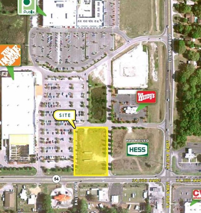
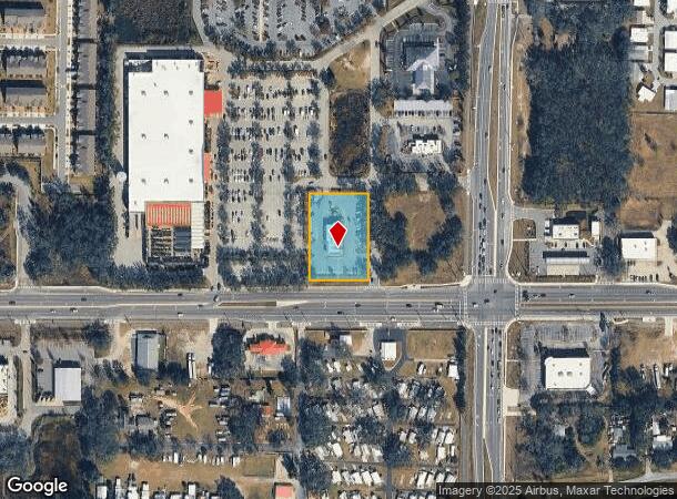
34367 Wesley Chapel Blvd
Tampa-St. Petersburg-Clearwater, FL
Outparcel To Shopping Center
18-26-21-0000-01500-0030
COM NE COR OF NE1/4 OF SW1/4 OF SEC 18 TH N89DEG 3512W 187.87 FT TO W R/W LN OF EILAND BLVD TH S01DEG 4008E 427.8 FT TH CV R RAD 3346 FT CHD S00DEG 1117W 217.48 FT TH S02DEG 0403W 336.8 FT TH N89DEG 5550W 248.73 FT TH S00DEG0153E 295.22 FT TH S89 DEG
Restaurantdrivein
Pasco
X
Florida
12101C0451F
3
2024
1.14 AC
2025
Pasco County
032106
Tampa/St Petersburg
4,304 SF
DEMOGRAPHICS near 34367 Wesley Chapel Blvd
1 Mile
3 Mile
5 Mile
2024 Total Population
6,641
37,918
106,148
2029 Population
8,161
46,507
129,782
Pop Growth 2024-2029
+ 22.89%
+ 22.65%
+ 22.27%
Average Age
51
45
43
2024 Total Households
3,012
15,245
41,559
HH Growth 2024-2029
+ 22.78%
+ 22.55%
+ 22.23%
Median Household Inc
$45,409
$57,729
$61,912
Avg Household Size
2.10
2.40
2.50
2024 Avg HH Vehicles
1.00
2.00
2.00
Median Home Value
$91,627
$215,451
$230,706
Median Year Built
1993
1997
1999
Nearby Places
Map Layers
Map Styles
 Street
 Aerial
- Restaurants
- Banks
- Shops
- Fitness
- Groceries
PUBLIC TRANSPORTATION
AIRPORT
Tampa International
DRIVE
WALK
Distance
Tampa International
52 min
35.7 mi
St Pete-Clearwater International
DRIVE
WALK
Distance
St Pete-Clearwater International
69 min
45.7 mi
Nearby Properties
Address
Land Use
TOTAL SIZE
Lot Size
Zoning
Address
Land Use
TOTAL SIZE
Lot Size
Zoning
277,779 SF
18.93 AC
MPUD
Address
Land Use
TOTAL SIZE
Lot Size
Zoning
253,292 SF
22.26 AC
MPUD
Address
Land Use
TOTAL SIZE
Lot Size
Zoning
309,662 SF
59.03 AC
MF1
Address
Land Use
TOTAL SIZE
Lot Size
Zoning
252,942 SF
13.59 AC
MPUD
Address
Land Use
TOTAL SIZE
Lot Size
Zoning
245,602 SF
12.57 AC
MPUD
Address
Land Use
TOTAL SIZE
Lot Size
Zoning
109,440 SF
3.28 AC
C2
Address
Land Use
TOTAL SIZE
Lot Size
Zoning
92,475 SF
19.45 AC
MPUD
Address
Land Use
TOTAL SIZE
Lot Size
Zoning
19.81 AC
MPUD
Address
Land Use
TOTAL SIZE
Lot Size
Zoning
90,404 SF
17.90 AC
MPUD
Address
Land Use
TOTAL SIZE
Lot Size
Zoning
129,416 SF
3.87 AC
C2
Address
Land Use
TOTAL SIZE
Lot Size
Zoning
33.29 AC
MPUD
Address
Land Use
TOTAL SIZE
Lot Size
Zoning
93,395 SF
6.71 AC
MPUD
Address
Land Use
TOTAL SIZE
Lot Size
Zoning
22.39 AC
MPUD
Address
Land Use
TOTAL SIZE
Lot Size
Zoning
11,189 SF
34.32 AC
C2
Address
Land Use
TOTAL SIZE
Lot Size
Zoning
82,605 SF
37.03 AC
AR
Address
Land Use
TOTAL SIZE
Lot Size
Zoning
69,405 SF
2.15 AC
MPUD
Address
Land Use
TOTAL SIZE
Lot Size
Zoning
101.06 AC
MPUD
Address
Land Use
TOTAL SIZE
Lot Size
Zoning
104,720 SF
13.22 AC
C2
Address
Land Use
TOTAL SIZE
Lot Size
Zoning
64,769 SF
11.78 AC
C2
Address
Land Use
TOTAL SIZE
Lot Size
Zoning
209.20 AC
MPUD
Address
Land Use
TOTAL SIZE
Lot Size
Zoning
107,022 SF
13.27 AC
C2
Address
Land Use
TOTAL SIZE
Lot Size
Zoning
39,560 SF
6.31 AC
MPUD
Address
Land Use
TOTAL SIZE
Lot Size
Zoning
76,015 SF
9.18 AC
C2
Address
Land Use
TOTAL SIZE
Lot Size
Zoning
61,636 SF
6.84 AC
C2
Address
Land Use
TOTAL SIZE
Lot Size
Zoning
38,397 SF
7.18 AC
C2
Address
Land Use
TOTAL SIZE
Lot Size
Zoning
58,090 SF
5.30 AC
MF1
Address
Land Use
TOTAL SIZE
Lot Size
Zoning
20,543 SF
4.18 AC
C2
Address
Land Use
TOTAL SIZE
Lot Size
Zoning
63,200 SF
29.69 AC
C2
Address
Land Use
TOTAL SIZE
Lot Size
Zoning
58,184 SF
3.93 AC
C2
Address
Land Use
TOTAL SIZE
Lot Size
Zoning
97.70 AC
MPUD
The World's #1 Commercial Real Estate Marketplace
Connect with us
© 2025 CoStar Group
The information above has been obtained from sources believed reliable. While we do not doubt its accuracy we have not verified it and make no guarantee, warranty or representation about it. It is your responsibility to independently confirm its accuracy and completeness. Any projections, opinions, assumptions, or estimates used are for example only and do not represent the current or future performance of the property. The value of this transaction to you depends on tax and other factors which should be evaluated by your tax, financial, and legal advisors. You and your advisors should conduct a careful, independent investigation of the property to determine to your satisfaction the suitability of the property for your needs.