Property Record
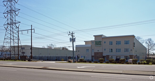
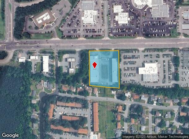
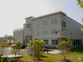
3437 Western Branch Blvd, Chesapeake, VA 23321
NEARBY LISTINGS FOR SALE OR LEASE
-
-
View all Chesapeake listings for sale on LoopNet.com
Property Detail
3437 Western Branch Blvd
0041001000150
Western Branch Blvd Corridor
Publicstorage
13 14 15 PLAT OF M W ARMISTEAD JR PROP 2.55 AC
X
Chesapeake
5155290056D
Virginia
2024
2.55 AC
2025
Western Branch
021602
Hampton Roads
97,524 SF
Virginia Beach-Norfolk-Newport News, VA-NC
DEMOGRAPHICS near 3437 Western Branch Blvd
1 Mile
3 Mile
5 Mile
2024 Total Population
14,160
66,359
115,012
2029 Population
14,794
69,400
119,185
Pop Growth 2024-2029
+ 4.48%
+ 4.58%
+ 3.63%
Average Age
36
38
39
2024 Total Households
5,756
25,771
44,831
HH Growth 2024-2029
+ 4.66%
+ 4.73%
+ 3.58%
Median Household Inc
$64,981
$83,593
$81,477
Avg Household Size
2.40
2.50
2.50
2024 Avg HH Vehicles
2.00
2.00
2.00
Median Home Value
$226,154
$280,934
$270,610
Median Year Built
1983
1988
1982
Nearby Places
Map Layers
Map Styles
 Street
 Aerial
- Restaurants
- Banks
- Shops
- Fitness
- Groceries
PUBLIC TRANSPORTATION
AIRPORT
Norfolk International
DRIVE
WALK
Distance
Norfolk International
28 min
15.2 mi
Newport News/Williamsburg International
DRIVE
WALK
Distance
Newport News/Williamsburg International
36 min
24.9 mi
Nearby Properties
Address
Land Use
TOTAL SIZE
Lot Size
Zoning
Address
Land Use
TOTAL SIZE
Lot Size
Zoning
2,400 SF
125.24 AC
HEAVY INDU
Address
Land Use
TOTAL SIZE
Lot Size
Zoning
285,162 SF
101.91 AC
R10S: RESI
Address
Land Use
TOTAL SIZE
Lot Size
Zoning
13.52 AC
MIXED USE
Address
Land Use
TOTAL SIZE
Lot Size
Zoning
203,610 SF
89.39 AC
GR
Address
Land Use
TOTAL SIZE
Lot Size
Zoning
4,080 SF
41.46 AC
LIGHT INDU
Address
Land Use
TOTAL SIZE
Lot Size
Zoning
30.85 AC
PLANNED DE
Address
Land Use
TOTAL SIZE
Lot Size
Zoning
31,635 SF
10.36 AC
MIXED USE
Address
Land Use
TOTAL SIZE
Lot Size
Zoning
6,446 SF
8.76 AC
MIXED USE
Address
Land Use
TOTAL SIZE
Lot Size
Zoning
681,685 SF
52.59 AC
LIGHT INDU
Address
Land Use
TOTAL SIZE
Lot Size
Zoning
278,978 SF
26.63 AC
LIGHT INDU
Address
Land Use
TOTAL SIZE
Lot Size
Zoning
97,411 SF
17.90 AC
GENERAL CO
Address
Land Use
TOTAL SIZE
Lot Size
Zoning
46.66 AC
LIGHT INDU
Address
Land Use
TOTAL SIZE
Lot Size
Zoning
22,723 SF
10.97 AC
GENERAL CO
Address
Land Use
TOTAL SIZE
Lot Size
Zoning
166,481 SF
11.15 AC
OFFICE-INS
Address
Land Use
TOTAL SIZE
Lot Size
Zoning
287,348 SF
20.21 AC
URM
Address
Land Use
TOTAL SIZE
Lot Size
Zoning
43,917 SF
5.72 AC
MIXED USE
Address
Land Use
TOTAL SIZE
Lot Size
Zoning
15,746 SF
24.70 AC
GENERAL CO
Address
Land Use
TOTAL SIZE
Lot Size
Zoning
101,959 SF
12.65 AC
LIGHT INDU
Address
Land Use
TOTAL SIZE
Lot Size
Zoning
73,039 SF
11.68 AC
RMF1: MULT
Address
Land Use
TOTAL SIZE
Lot Size
Zoning
126,000 SF
21.51 AC
LIGHT INDU
Address
Land Use
TOTAL SIZE
Lot Size
Zoning
41,440 SF
6.60 AC
LIGHT INDU
Address
Land Use
TOTAL SIZE
Lot Size
Zoning
183,100 SF
25.30 AC
GR
Address
Land Use
TOTAL SIZE
Lot Size
Zoning
121,200 SF
9.81 AC
PUD: PLANN
Address
Land Use
TOTAL SIZE
Lot Size
Zoning
235,968 SF
13.25 AC
RMF1: MULT
Address
Land Use
TOTAL SIZE
Lot Size
Zoning
222,810 SF
42.16 AC
MULTI: MUL
The World's #1 Commercial Real Estate Marketplace
Connect with us
© 2026 CoStar Group
The information above has been obtained from sources believed reliable. While we do not doubt its accuracy we have not verified it and make no guarantee, warranty or representation about it. It is your responsibility to independently confirm its accuracy and completeness. Any projections, opinions, assumptions, or estimates used are for example only and do not represent the current or future performance of the property. The value of this transaction to you depends on tax and other factors which should be evaluated by your tax, financial, and legal advisors. You and your advisors should conduct a careful, independent investigation of the property to determine to your satisfaction the suitability of the property for your needs.