Property Record
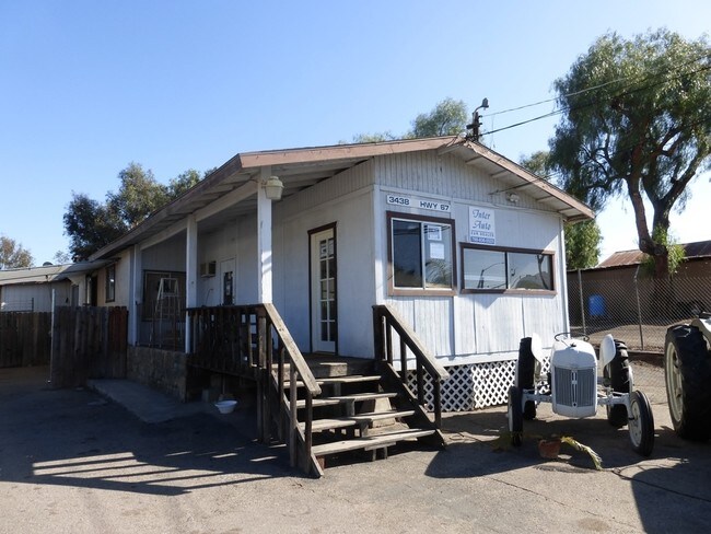
3438 Highway 67, Ramona, CA 92065


NEARBY LISTINGS FOR SALE OR LEASE
Property Detail
3438 Highway 67
283-055-70
Rancho Santa Maria
Vehiclerentalsvehiclesales
SEC 29-13-1E W H (EX HWY)MOST ELY PAR AS PER ROS 5824 IN TR 000863
X
San Diego
06073C1118G
California
2024
0.66 AC
2025
Outlying SD County N
020801
San Diego
2,040 SF
San Diego-Carlsbad, CA
DEMOGRAPHICS near 3438 Highway 67
1 Mile
3 Mile
5 Mile
2024 Total Population
954
13,433
22,964
2029 Population
919
13,146
22,519
Pop Growth 2024-2029
(3.67%)
(2.14%)
(1.94%)
Average Age
44
40
40
2024 Total Households
339
4,548
7,663
HH Growth 2024-2029
(4.13%)
(2.35%)
(2.17%)
Median Household Inc
$127,365
$91,193
$98,026
Avg Household Size
2.70
2.80
2.90
2024 Avg HH Vehicles
3.00
2.00
3.00
Median Home Value
$785,024
$715,664
$726,129
Median Year Built
1982
1980
1979
Nearby Places
Map Layers
Map Styles
 Street
 Aerial
- Restaurants
- Banks
- Shops
- Fitness
- Groceries
PUBLIC TRANSPORTATION
AIRPORT
San Diego International
DRIVE
WALK
Distance
San Diego International
46 min
33.2 mi
Freight Ports
Port of San Diego
DRIVE
WALK
Distance
Port of San Diego
49 min
35.4 mi
SALE & LEASE HISTORY
LISTING DATE
SALE/LEASE

Mar 11, 2021
For Sale
Nearby Properties
Address
Land Use
TOTAL SIZE
Lot Size
Zoning
Address
Land Use
TOTAL SIZE
Lot Size
Zoning
9.63 AC
RMV4
Address
Land Use
TOTAL SIZE
Lot Size
Zoning
4.79 AC
RMV4
Address
Land Use
TOTAL SIZE
Lot Size
Zoning
24.83 AC
RMH6
Address
Land Use
TOTAL SIZE
Lot Size
Zoning
69,060 SF
2.79 AC
RMV4
Address
Land Use
TOTAL SIZE
Lot Size
Zoning
65,361 SF
4.78 AC
RV
Address
Land Use
TOTAL SIZE
Lot Size
Zoning
51,250 SF
3.15 AC
RMV4
Address
Land Use
TOTAL SIZE
Lot Size
Zoning
9.91 AC
RMV5
Address
Land Use
TOTAL SIZE
Lot Size
Zoning
35,248 SF
1.41 AC
RMV4
Address
Land Use
TOTAL SIZE
Lot Size
Zoning
35,878 SF
1.85 AC
RMV5
Address
Land Use
TOTAL SIZE
Lot Size
Zoning
10.63 AC
M54
Address
Land Use
TOTAL SIZE
Lot Size
Zoning
32,160 SF
3.19 AC
RMV5
Address
Land Use
TOTAL SIZE
Lot Size
Zoning
Address
Land Use
TOTAL SIZE
Lot Size
Zoning
46,996 SF
3.66 AC
RMV5
Address
Land Use
TOTAL SIZE
Lot Size
Zoning
36,248 SF
5.28 AC
RMV2
Address
Land Use
TOTAL SIZE
Lot Size
Zoning
46,450 SF
2.87 AC
RMV5
Address
Land Use
TOTAL SIZE
Lot Size
Zoning
35,103 SF
3.41 AC
RU
Address
Land Use
TOTAL SIZE
Lot Size
Zoning
380 AC
S88
Address
Land Use
TOTAL SIZE
Lot Size
Zoning
22,224 SF
2.30 AC
RMV5
Address
Land Use
TOTAL SIZE
Lot Size
Zoning
18,800 SF
3.32 AC
RMV5
Address
Land Use
TOTAL SIZE
Lot Size
Zoning
4.54 AC
RMV5
Address
Land Use
TOTAL SIZE
Lot Size
Zoning
36,226 SF
1.51 AC
RMV5
Address
Land Use
TOTAL SIZE
Lot Size
Zoning
1.69 AC
RMV5
Address
Land Use
TOTAL SIZE
Lot Size
Zoning
19,857 SF
2.50 AC
RMV5
Address
Land Use
TOTAL SIZE
Lot Size
Zoning
81,935 SF
2.93 AC
RMV4
Address
Land Use
TOTAL SIZE
Lot Size
Zoning
0.87 AC
RMV5
Address
Land Use
TOTAL SIZE
Lot Size
Zoning
22,880 SF
0.97 AC
RMV4
Address
Land Use
TOTAL SIZE
Lot Size
Zoning
18,750 SF
0.91 AC
RMV3
Address
Land Use
TOTAL SIZE
Lot Size
Zoning
35,342 SF
2.76 AC
RMV5
Address
Land Use
TOTAL SIZE
Lot Size
Zoning
16,576 SF
1.52 AC
RMV4
Address
Land Use
TOTAL SIZE
Lot Size
Zoning
14,516 SF
1.22 AC
RMV5
The World's #1 Commercial Real Estate Marketplace
Connect with us
© 2025 CoStar Group
The information above has been obtained from sources believed reliable. While we do not doubt its accuracy we have not verified it and make no guarantee, warranty or representation about it. It is your responsibility to independently confirm its accuracy and completeness. Any projections, opinions, assumptions, or estimates used are for example only and do not represent the current or future performance of the property. The value of this transaction to you depends on tax and other factors which should be evaluated by your tax, financial, and legal advisors. You and your advisors should conduct a careful, independent investigation of the property to determine to your satisfaction the suitability of the property for your needs.