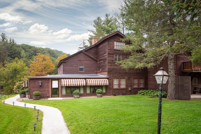
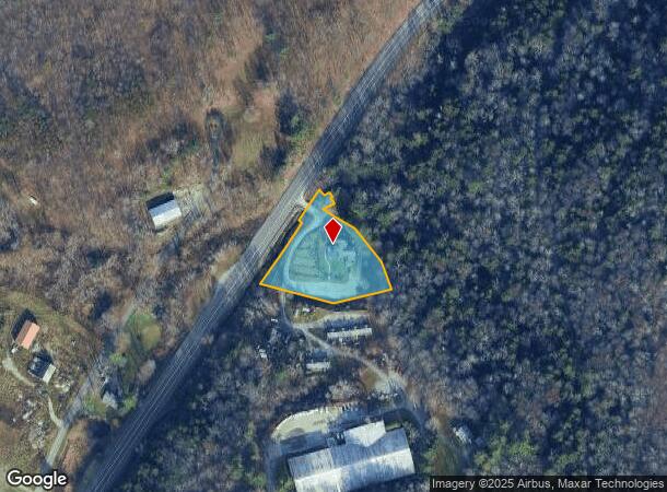
Property Record
344 Route 7, Lanesborough, MA 01237
NEARBY LISTINGS FOR SALE OR LEASE
-
-
View all Lanesborough listings for sale on LoopNet.com
Property Detail
344 Route 7
Pittsfield, MA
Berkshire
NEWA-000008-000000-000015
Massachusetts
Commercialofficeresidentialmixeduse
15
2025
1.20 AC
2025
Massachusetts North/West Area
935100
Other Market Areas
4,930 SF
DEMOGRAPHICS near 344 Route 7
1 Mile
3 Mile
5 Mile
2024 Total Population
158
478
3,083
2029 Population
152
464
3,035
Pop Growth 2024-2029
(3.80%)
(2.93%)
(1.56%)
Average Age
48
48
48
2024 Total Households
69
206
1,308
HH Growth 2024-2029
(4.35%)
(3.40%)
(1.68%)
Median Household Inc
$69,999
$74,347
$74,644
Avg Household Size
2.30
2.30
2.30
2024 Avg HH Vehicles
2.00
2.00
2.00
Median Home Value
$320,588
$332,143
$280,520
Median Year Built
1963
1973
1970
Nearby Places
Map Layers
Map Styles
 Street
 Aerial
- Restaurants
- Banks
- Shops
- Fitness
- Groceries
PUBLIC TRANSPORTATION
AIRPORT
Albany International
DRIVE
WALK
Distance
Albany International
68 min
40.6 mi
Freight Ports
Albany, NY Port
DRIVE
WALK
Distance
Albany, NY Port
62 min
36.3 mi
SALE & LEASE HISTORY
LISTING DATE
SALE/LEASE

Nov 29, 2018
For Sale
Jun 15, 2020
For Sale
Jul 08, 2021
For Sale
Nearby Properties
Address
Land Use
TOTAL SIZE
Lot Size
Zoning
Address
Land Use
TOTAL SIZE
Lot Size
Zoning
1,889 AC
Address
Land Use
TOTAL SIZE
Lot Size
Zoning
419 AC
Address
Land Use
TOTAL SIZE
Lot Size
Zoning
Address
Land Use
TOTAL SIZE
Lot Size
Zoning
21,150 SF
382.99 AC
Address
Land Use
TOTAL SIZE
Lot Size
Zoning
4,514 SF
62.26 AC
1
Address
Land Use
TOTAL SIZE
Lot Size
Zoning
684 AC
Address
Land Use
TOTAL SIZE
Lot Size
Zoning
12,384 SF
512.09 AC
Address
Land Use
TOTAL SIZE
Lot Size
Zoning
161 AC
LB
Address
Land Use
TOTAL SIZE
Lot Size
Zoning
41,072 SF
4.30 AC
Address
Land Use
TOTAL SIZE
Lot Size
Zoning
Address
Land Use
TOTAL SIZE
Lot Size
Zoning
13,920 SF
6.33 AC
Address
Land Use
TOTAL SIZE
Lot Size
Zoning
8,298 SF
2.02 AC
Address
Land Use
TOTAL SIZE
Lot Size
Zoning
558.80 AC
AR
Address
Land Use
TOTAL SIZE
Lot Size
Zoning
5.64 AC
1
Address
Land Use
TOTAL SIZE
Lot Size
Zoning
194.63 AC
1
Address
Land Use
TOTAL SIZE
Lot Size
Zoning
4.20 AC
Address
Land Use
TOTAL SIZE
Lot Size
Zoning
2,261 SF
2.01 AC
Address
Land Use
TOTAL SIZE
Lot Size
Zoning
314 AC
AR
Address
Land Use
TOTAL SIZE
Lot Size
Zoning
276.83 AC
1
Address
Land Use
TOTAL SIZE
Lot Size
Zoning
333.51 AC
1
Address
Land Use
TOTAL SIZE
Lot Size
Zoning
137.20 AC
RR2
Address
Land Use
TOTAL SIZE
Lot Size
Zoning
6,904 SF
14 AC
Address
Land Use
TOTAL SIZE
Lot Size
Zoning
93 AC
R-A
Address
Land Use
TOTAL SIZE
Lot Size
Zoning
124 AC
Address
Land Use
TOTAL SIZE
Lot Size
Zoning
3,620 SF
0.22 AC
Address
Land Use
TOTAL SIZE
Lot Size
Zoning
88.63 AC
RA
Address
Land Use
TOTAL SIZE
Lot Size
Zoning
152 AC
1
Address
Land Use
TOTAL SIZE
Lot Size
Zoning
960 SF
8.69 AC
RR2
Address
Land Use
TOTAL SIZE
Lot Size
Zoning
138 AC
RR2
The World's #1 Commercial Real Estate Marketplace
Connect with us
© 2025 CoStar Group
The information above has been obtained from sources believed reliable. While we do not doubt its accuracy we have not verified it and make no guarantee, warranty or representation about it. It is your responsibility to independently confirm its accuracy and completeness. Any projections, opinions, assumptions, or estimates used are for example only and do not represent the current or future performance of the property. The value of this transaction to you depends on tax and other factors which should be evaluated by your tax, financial, and legal advisors. You and your advisors should conduct a careful, independent investigation of the property to determine to your satisfaction the suitability of the property for your needs.