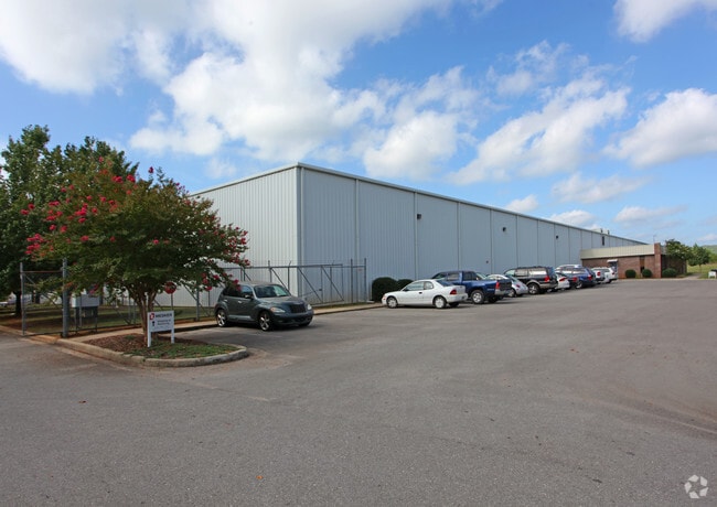
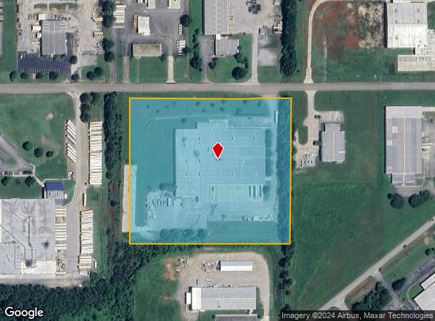
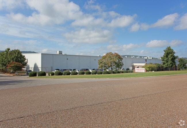
Property Record
3440 Stanwood Blvd Ne, Huntsville, AL 35811
NEARBY LISTINGS FOR SALE OR LEASE
Property Detail
3440 Stanwood Blvd Ne
13-05-16-0-000-008.001
SEC 16 T3S R1E PT OF SEC 16 DESC AS COMM AT THE NW COR OF SEC 16 TH S 1208.43 FT E 1581.95 FT & N 89 DEG E 1686.23 FT TO THE
Officebuilding
Madison
X
Alabama
01089C0194F
11 AC
2025
North Huntsville
2025
Huntsville
000203
Huntsville, AL
3,840 SF
DEMOGRAPHICS near 3440 Stanwood Blvd Ne
1 Mile
3 Mile
5 Mile
2024 Total Population
1,717
21,651
68,732
2029 Population
1,920
23,636
75,989
Pop Growth 2024-2029
+ 11.82%
+ 9.17%
+ 10.56%
Average Age
42
39
40
2024 Total Households
697
7,515
27,278
HH Growth 2024-2029
+ 12.48%
+ 11.08%
+ 11.51%
Median Household Inc
$94,360
$88,518
$74,141
Avg Household Size
2.40
2.40
2.30
2024 Avg HH Vehicles
2.00
2.00
2.00
Median Home Value
$238,818
$247,847
$236,154
Median Year Built
2001
1993
1980
Nearby Places
Map Layers
Map Styles
 Street
 Aerial
- Restaurants
- Banks
- Shops
- Fitness
- Groceries
PUBLIC TRANSPORTATION
AIRPORT
Huntsville International-Carl T Jones Field
DRIVE
WALK
Distance
Huntsville International-Carl T Jones Field
28 min
19.9 mi
Freight Ports
Port of Mobile
DRIVE
WALK
Distance
Port of Mobile
396 min
361.1 mi
Nearby Properties
Address
Land Use
TOTAL SIZE
Lot Size
Zoning
Address
Land Use
TOTAL SIZE
Lot Size
Zoning
672 SF
105 AC
Address
Land Use
TOTAL SIZE
Lot Size
Zoning
13,388 SF
18 AC
Address
Land Use
TOTAL SIZE
Lot Size
Zoning
7,848 SF
14.40 AC
Address
Land Use
TOTAL SIZE
Lot Size
Zoning
14,652 SF
16.62 AC
Address
Land Use
TOTAL SIZE
Lot Size
Zoning
1,440 SF
22 AC
Address
Land Use
TOTAL SIZE
Lot Size
Zoning
20,160 SF
157 AC
Address
Land Use
TOTAL SIZE
Lot Size
Zoning
6,600 SF
12 AC
Address
Land Use
TOTAL SIZE
Lot Size
Zoning
71,695 SF
7.80 AC
Address
Land Use
TOTAL SIZE
Lot Size
Zoning
201,250 SF
15 AC
Address
Land Use
TOTAL SIZE
Lot Size
Zoning
1,740 SF
24 AC
Address
Land Use
TOTAL SIZE
Lot Size
Zoning
254,514 SF
20 AC
Address
Land Use
TOTAL SIZE
Lot Size
Zoning
57,106 SF
47 AC
Address
Land Use
TOTAL SIZE
Lot Size
Zoning
141,120 SF
15 AC
Address
Land Use
TOTAL SIZE
Lot Size
Zoning
7,950 SF
63 AC
Address
Land Use
TOTAL SIZE
Lot Size
Zoning
17,946 SF
5 AC
Address
Land Use
TOTAL SIZE
Lot Size
Zoning
20.80 AC
Address
Land Use
TOTAL SIZE
Lot Size
Zoning
207,500 SF
25 AC
Address
Land Use
TOTAL SIZE
Lot Size
Zoning
223,500 SF
6.60 AC
Address
Land Use
TOTAL SIZE
Lot Size
Zoning
Address
Land Use
TOTAL SIZE
Lot Size
Zoning
3,293 SF
3 AC
Address
Land Use
TOTAL SIZE
Lot Size
Zoning
23,944 SF
13 AC
Address
Land Use
TOTAL SIZE
Lot Size
Zoning
5,905 SF
16 AC
Address
Land Use
TOTAL SIZE
Lot Size
Zoning
8,862 SF
6.40 AC
Address
Land Use
TOTAL SIZE
Lot Size
Zoning
3,450 SF
4.48 AC
Address
Land Use
TOTAL SIZE
Lot Size
Zoning
Address
Land Use
TOTAL SIZE
Lot Size
Zoning
55,319 SF
6.16 AC
Address
Land Use
TOTAL SIZE
Lot Size
Zoning
100,000 SF
11 AC
Address
Land Use
TOTAL SIZE
Lot Size
Zoning
19,031 SF
6.40 AC
Address
Land Use
TOTAL SIZE
Lot Size
Zoning
44,925 SF
6.90 AC
Address
Land Use
TOTAL SIZE
Lot Size
Zoning
6,620 SF
6.81 AC
The World's #1 Commercial Real Estate Marketplace
Connect with us
© 2025 CoStar Group
The information above has been obtained from sources believed reliable. While we do not doubt its accuracy we have not verified it and make no guarantee, warranty or representation about it. It is your responsibility to independently confirm its accuracy and completeness. Any projections, opinions, assumptions, or estimates used are for example only and do not represent the current or future performance of the property. The value of this transaction to you depends on tax and other factors which should be evaluated by your tax, financial, and legal advisors. You and your advisors should conduct a careful, independent investigation of the property to determine to your satisfaction the suitability of the property for your needs.