Property Record
3443 W 5600 S, Roy, UT 84067
NEARBY LISTINGS FOR SALE OR LEASE
-
-
View all Roy listings for sale on LoopNet.com
Property Detail
3443 W 5600 S
Ogden-Clearfield, UT
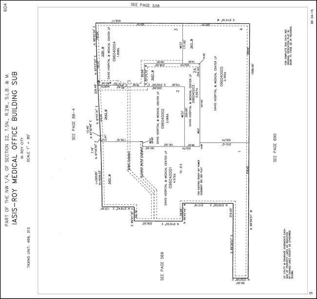
Iasis Roy Medical Office Building Subdiv
09-604-0002
ALL OF LOT 4, IASIS-ROY MEDICAL OFFICE BUILDING SUBDIVISION, ROY CITY, WEBER COUNTY, UTAH.
Medicalbuilding
Weber
X
Utah
49011C0070E
4
2025
2.07 AC
2025
Davis/Weber Counties
210704
Salt Lake City
22,644 SF
DEMOGRAPHICS near 3443 W 5600 S
1 Mile
3 Mile
5 Mile
2024 Total Population
13,910
92,246
164,323
2029 Population
14,825
98,499
176,063
Pop Growth 2024-2029
+ 6.58%
+ 6.78%
+ 7.14%
Average Age
35
35
34
2024 Total Households
4,247
28,858
51,759
HH Growth 2024-2029
+ 6.78%
+ 6.89%
+ 7.31%
Median Household Inc
$83,063
$83,943
$82,372
Avg Household Size
3.20
3.10
3.10
2024 Avg HH Vehicles
2.00
2.00
2.00
Median Home Value
$333,650
$357,649
$369,399
Median Year Built
1991
1992
1992
Nearby Places
Map Layers
Map Styles
 Street
 Aerial
- Restaurants
- Banks
- Shops
- Fitness
- Groceries
PUBLIC TRANSPORTATION
COMMUTER RAIL
Roy (FrontRunner North - Utah Transit Authority (UTA))
DRIVE
WALK
Distance
Roy (FrontRunner North - Utah Transit Authority (UTA))
7 min
3.5 mi
Clearfield (FrontRunner North - Utah Transit Authority (UTA))
DRIVE
WALK
Distance
Clearfield (FrontRunner North - Utah Transit Authority (UTA))
15 min
7.5 mi
AIRPORT
Salt Lake City International
DRIVE
WALK
Distance
Salt Lake City International
45 min
35.7 mi
Freight Ports
Port of Stockton
DRIVE
WALK
Distance
Port of Stockton
746 min
726.1 mi
Nearby Properties
Address
Land Use
TOTAL SIZE
Lot Size
Zoning
Address
Land Use
TOTAL SIZE
Lot Size
Zoning
35,219 SF
58.98 AC
Address
Land Use
TOTAL SIZE
Lot Size
Zoning
7,492 SF
8.96 AC
Address
Land Use
TOTAL SIZE
Lot Size
Zoning
71,940 SF
11 AC
Address
Land Use
TOTAL SIZE
Lot Size
Zoning
223,079 SF
22.55 AC
Address
Land Use
TOTAL SIZE
Lot Size
Zoning
69,331 SF
7.46 AC
R2
Address
Land Use
TOTAL SIZE
Lot Size
Zoning
62,246 SF
5.37 AC
PZ
Address
Land Use
TOTAL SIZE
Lot Size
Zoning
21,980 SF
11.68 AC
Address
Land Use
TOTAL SIZE
Lot Size
Zoning
140,015 SF
12.14 AC
PZ
Address
Land Use
TOTAL SIZE
Lot Size
Zoning
88,125 SF
7.17 AC
PZ
Address
Land Use
TOTAL SIZE
Lot Size
Zoning
58,287 SF
5.18 AC
Address
Land Use
TOTAL SIZE
Lot Size
Zoning
50,440 SF
5.26 AC
Address
Land Use
TOTAL SIZE
Lot Size
Zoning
50,432 SF
3.86 AC
R115
Address
Land Use
TOTAL SIZE
Lot Size
Zoning
45,772 SF
5 AC
Address
Land Use
TOTAL SIZE
Lot Size
Zoning
1,620 SF
3.74 AC
Address
Land Use
TOTAL SIZE
Lot Size
Zoning
20,010 SF
8.33 AC
Address
Land Use
TOTAL SIZE
Lot Size
Zoning
45,160 SF
10.93 AC
Address
Land Use
TOTAL SIZE
Lot Size
Zoning
33,818 SF
3.27 AC
Address
Land Use
TOTAL SIZE
Lot Size
Zoning
95,394 SF
8.83 AC
Address
Land Use
TOTAL SIZE
Lot Size
Zoning
56,500 SF
8.02 AC
Address
Land Use
TOTAL SIZE
Lot Size
Zoning
16.99 AC
Address
Land Use
TOTAL SIZE
Lot Size
Zoning
22,656 SF
5.42 AC
PZ
Address
Land Use
TOTAL SIZE
Lot Size
Zoning
72,653 SF
8.78 AC
C2
Address
Land Use
TOTAL SIZE
Lot Size
Zoning
104,709 SF
2.28 AC
Address
Land Use
TOTAL SIZE
Lot Size
Zoning
64,119 SF
1.46 AC
C2
The World's #1 Commercial Real Estate Marketplace
Connect with us
© 2026 CoStar Group
The information above has been obtained from sources believed reliable. While we do not doubt its accuracy we have not verified it and make no guarantee, warranty or representation about it. It is your responsibility to independently confirm its accuracy and completeness. Any projections, opinions, assumptions, or estimates used are for example only and do not represent the current or future performance of the property. The value of this transaction to you depends on tax and other factors which should be evaluated by your tax, financial, and legal advisors. You and your advisors should conduct a careful, independent investigation of the property to determine to your satisfaction the suitability of the property for your needs.