Property Record
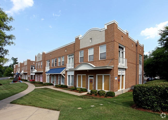
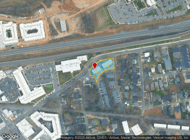
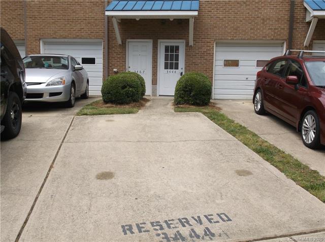
3444 N Davidson St, Charlotte, NC 28205
This Property Is For Sale
NEARBY LISTINGS FOR SALE OR LEASE
Property Detail
3444 N Davidson St
Charlotte-Concord-Gastonia, NC-SC
Shops/Colony Condo
091-101-37
UNIT B U/F 629-1
Commercialcondominium
Mecklenburg
X
North Carolina
3710456500K
98
0
0.67 AC
2025
Northeast
001400
Charlotte
654 SF
DEMOGRAPHICS near 3444 N Davidson St
1 Mile
3 Mile
5 Mile
2024 Total Population
13,153
110,360
288,012
2029 Population
14,293
118,144
307,053
Pop Growth 2024-2029
+ 8.67%
+ 7.05%
+ 6.61%
Average Age
35
36
36
2024 Total Households
6,370
49,875
126,171
HH Growth 2024-2029
+ 8.71%
+ 7.24%
+ 6.80%
Median Household Inc
$64,525
$58,920
$62,543
Avg Household Size
2.00
2.10
2.20
2024 Avg HH Vehicles
1.00
1.00
2.00
Median Home Value
$456,036
$331,305
$305,740
Median Year Built
1999
1988
1991
Nearby Places
- Restaurants
- Banks
- Shops
- Fitness
- Groceries
PUBLIC TRANSPORTATION
TRANSIT/SUBWAY
36Th St Station (Light Rail - Lynx Blue Line - CATS)
DRIVE
WALK
Distance
36Th St Station (Light Rail - Lynx Blue Line - CATS)
1 min
6 min
0.4 mi
Sugar Creek Station (Light Rail - Lynx Blue Line - CATS)
DRIVE
WALK
Distance
Sugar Creek Station (Light Rail - Lynx Blue Line - CATS)
4 min
13 min
0.7 mi
COMMUTER RAIL
Charlotte Amtrak Station (Carolinian - Amtrak, Crescent - Amtrak, Piedmont - Amtrak)
DRIVE
WALK
Distance
Charlotte Amtrak Station (Carolinian - Amtrak, Crescent - Amtrak, Piedmont - Amtrak)
5 min
2.1 mi
AIRPORT
Charlotte/Douglas International
DRIVE
WALK
Distance
Charlotte/Douglas International
22 min
10.9 mi
Concord-Padgett Regional
DRIVE
WALK
Distance
Concord-Padgett Regional
20 min
13.0 mi
Freight Ports
North Charleston Terminal
DRIVE
WALK
Distance
North Charleston Terminal
234 min
203.6 mi
Nearby Properties
Address
Land Use
TOTAL SIZE
Lot Size
Zoning
Address
Land Use
TOTAL SIZE
Lot Size
Zoning
780,000 SF
7.69 AC
UMUD-O
Address
Land Use
TOTAL SIZE
Lot Size
Zoning
1,097,257 SF
2.34 AC
UMUD-O
Address
Land Use
TOTAL SIZE
Lot Size
Zoning
955,273 SF
1.83 AC
Address
Land Use
TOTAL SIZE
Lot Size
Zoning
1,250,218 SF
17.75 AC
O2
Address
Land Use
TOTAL SIZE
Lot Size
Zoning
1,097,857 SF
2.40 AC
UMUDO
Address
Land Use
TOTAL SIZE
Lot Size
Zoning
1,052,203 SF
2.17 AC
Address
Land Use
TOTAL SIZE
Lot Size
Zoning
1,752,744 SF
3.20 AC
UMUDO
Address
Land Use
TOTAL SIZE
Lot Size
Zoning
1,266,700 SF
2.98 AC
Address
Land Use
TOTAL SIZE
Lot Size
Zoning
852,355 SF
16.72 AC
MUDDO
Address
Land Use
TOTAL SIZE
Lot Size
Zoning
1,325,933 SF
34.09 AC
Address
Land Use
TOTAL SIZE
Lot Size
Zoning
1,053,936 SF
2.47 AC
UMUD
Address
Land Use
TOTAL SIZE
Lot Size
Zoning
865,160 SF
2.80 AC
UMUD
Address
Land Use
TOTAL SIZE
Lot Size
Zoning
839,976 SF
1.62 AC
UMUD
Address
Land Use
TOTAL SIZE
Lot Size
Zoning
1,017,564 SF
13.91 AC
O2
Address
Land Use
TOTAL SIZE
Lot Size
Zoning
916,725 SF
2.35 AC
UMUD
Address
Land Use
TOTAL SIZE
Lot Size
Zoning
944,863 SF
3.58 AC
UMUD
Address
Land Use
TOTAL SIZE
Lot Size
Zoning
1,039,198 SF
5.62 AC
UMUD
Address
Land Use
TOTAL SIZE
Lot Size
Zoning
864,694 SF
11.07 AC
MUDDO
Address
Land Use
TOTAL SIZE
Lot Size
Zoning
588,300 SF
1.45 AC
Address
Land Use
TOTAL SIZE
Lot Size
Zoning
768,780 SF
6.84 AC
UMUDO
Address
Land Use
TOTAL SIZE
Lot Size
Zoning
471,602 SF
1.82 AC
UMUD
Address
Land Use
TOTAL SIZE
Lot Size
Zoning
663,752 SF
1.21 AC
UMUD
Address
Land Use
TOTAL SIZE
Lot Size
Zoning
661,597 SF
2.76 AC
UMUD
Address
Land Use
TOTAL SIZE
Lot Size
Zoning
733,107 SF
3.48 AC
UMUD
Address
Land Use
TOTAL SIZE
Lot Size
Zoning
729,709 SF
10.67 AC
B2
Address
Land Use
TOTAL SIZE
Lot Size
Zoning
71.86 AC
UR-3
Address
Land Use
TOTAL SIZE
Lot Size
Zoning
690,862 SF
136.80 AC
R17MF
Address
Land Use
TOTAL SIZE
Lot Size
Zoning
447,803 SF
0.27 AC
Address
Land Use
TOTAL SIZE
Lot Size
Zoning
311,425 SF
0.92 AC
UMUD
Address
Land Use
TOTAL SIZE
Lot Size
Zoning
519,462 SF
0.61 AC
UMUD
The World's #1 Commercial Real Estate Marketplace
Connect with us
© 2025 CoStar Group
The information above has been obtained from sources believed reliable. While we do not doubt its accuracy we have not verified it and make no guarantee, warranty or representation about it. It is your responsibility to independently confirm its accuracy and completeness. Any projections, opinions, assumptions, or estimates used are for example only and do not represent the current or future performance of the property. The value of this transaction to you depends on tax and other factors which should be evaluated by your tax, financial, and legal advisors. You and your advisors should conduct a careful, independent investigation of the property to determine to your satisfaction the suitability of the property for your needs.