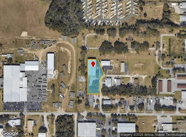
Property Record
3445 Sw 6Th St, Ocala, FL 34474
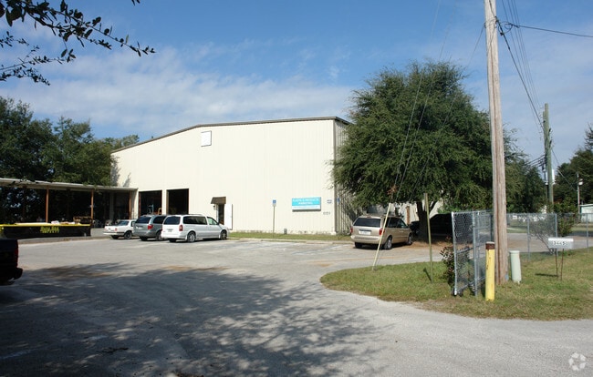
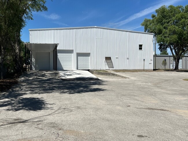
This Property Is For Sale
Current Lease Availabilities
NEARBY LISTINGS FOR SALE OR LEASE
Property Detail
3445 Sw 6Th St
Ocala, FL
South Forty Ind Park Phase Ii
2277-002-002
SEC 14 TWP 15 RGE 21 PLAT BOOK X PAGE 098 SOUTH FORTY IND PARK PHASE II BLK B LOTS 2.3
Lightindustrial
Marion
A
Florida
12083C0516E
2
2025
1.30 AC
2025
Greater Ocala
001600
Ocala
22,295 SF
DEMOGRAPHICS near 3445 Sw 6Th St
1 Mile
3 Mile
5 Mile
2024 Total Population
5,284
31,441
75,007
2029 Population
5,932
35,613
84,753
Pop Growth 2024-2029
+ 12.26%
+ 13.27%
+ 12.99%
Average Age
38
41
41
2024 Total Households
1,576
12,589
30,602
HH Growth 2024-2029
+ 13.45%
+ 13.40%
+ 13.04%
Median Household Inc
$40,139
$45,609
$51,197
Avg Household Size
2.30
2.30
2.30
2024 Avg HH Vehicles
1.00
1.00
2.00
Median Home Value
$118,584
$187,857
$208,612
Median Year Built
1985
1987
1986
Nearby Places
Map Layers
Map Styles
 Street
 Aerial
- Restaurants
- Banks
- Shops
- Fitness
- Groceries
Nearby Properties
Address
Land Use
TOTAL SIZE
Lot Size
Zoning
Address
Land Use
TOTAL SIZE
Lot Size
Zoning
207,950 SF
14.08 AC
INST
Address
Land Use
TOTAL SIZE
Lot Size
Zoning
2,015,469 SF
169.30 AC
M1
Address
Land Use
TOTAL SIZE
Lot Size
Zoning
704,765 SF
71.04 AC
GU
Address
Land Use
TOTAL SIZE
Lot Size
Zoning
493,261 SF
126.01 AC
R3
Address
Land Use
TOTAL SIZE
Lot Size
Zoning
331,687 SF
11.66 AC
INST
Address
Land Use
TOTAL SIZE
Lot Size
Zoning
446,764 SF
138.06 AC
GU
Address
Land Use
TOTAL SIZE
Lot Size
Zoning
1,085,670 SF
87.92 AC
M1
Address
Land Use
TOTAL SIZE
Lot Size
Zoning
164,363 SF
16.51 AC
R3
Address
Land Use
TOTAL SIZE
Lot Size
Zoning
195,992 SF
5.72 AC
FBC
Address
Land Use
TOTAL SIZE
Lot Size
Zoning
612,196 SF
50.06 AC
M1
Address
Land Use
TOTAL SIZE
Lot Size
Zoning
324,262 SF
40.79 AC
SC
Address
Land Use
TOTAL SIZE
Lot Size
Zoning
422,264 SF
40.87 AC
SC
Address
Land Use
TOTAL SIZE
Lot Size
Zoning
441,040 SF
150.01 AC
M1
Address
Land Use
TOTAL SIZE
Lot Size
Zoning
458,983 SF
35.14 AC
M1
Address
Land Use
TOTAL SIZE
Lot Size
Zoning
135,945 SF
22.30 AC
PD
Address
Land Use
TOTAL SIZE
Lot Size
Zoning
154,675 SF
23.62 AC
PD09
Address
Land Use
TOTAL SIZE
Lot Size
Zoning
87,034 SF
14.45 AC
R3
Address
Land Use
TOTAL SIZE
Lot Size
Zoning
178,015 SF
18.28 AC
PD07
Address
Land Use
TOTAL SIZE
Lot Size
Zoning
444,381 SF
60 AC
M1
Address
Land Use
TOTAL SIZE
Lot Size
Zoning
154,870 SF
23.50 AC
PD
Address
Land Use
TOTAL SIZE
Lot Size
Zoning
152,355 SF
973.50 AC
GU
Address
Land Use
TOTAL SIZE
Lot Size
Zoning
111,644 SF
19 AC
PD09
Address
Land Use
TOTAL SIZE
Lot Size
Zoning
403,023 SF
47.47 AC
M1
Address
Land Use
TOTAL SIZE
Lot Size
Zoning
62,164 SF
27.64 AC
PD
Address
Land Use
TOTAL SIZE
Lot Size
Zoning
222,210 SF
22.14 AC
SC
Address
Land Use
TOTAL SIZE
Lot Size
Zoning
92,049 SF
15.75 AC
R3
Address
Land Use
TOTAL SIZE
Lot Size
Zoning
65,570 SF
18.96 AC
PD
Address
Land Use
TOTAL SIZE
Lot Size
Zoning
110,226 SF
19.56 AC
PD09
Address
Land Use
TOTAL SIZE
Lot Size
Zoning
350,895 SF
27.85 AC
M1
Address
Land Use
TOTAL SIZE
Lot Size
Zoning
422,369 SF
51.11 AC
M2
The World's #1 Commercial Real Estate Marketplace
Connect with us
© 2026 CoStar Group
The information above has been obtained from sources believed reliable. While we do not doubt its accuracy we have not verified it and make no guarantee, warranty or representation about it. It is your responsibility to independently confirm its accuracy and completeness. Any projections, opinions, assumptions, or estimates used are for example only and do not represent the current or future performance of the property. The value of this transaction to you depends on tax and other factors which should be evaluated by your tax, financial, and legal advisors. You and your advisors should conduct a careful, independent investigation of the property to determine to your satisfaction the suitability of the property for your needs.