Property Record
3448 Highway 138 Ne, Conyers, GA 30013
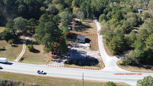

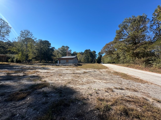
This Property Is For Sale
Property Detail
3448 Highway 138 Ne
Atlanta-Sandy Springs-Roswell, GA
NW/SIDE HWY 138 LANDLOT: 381 LANDDIST: 16
086-0-01-014H
ROCKDALE
Commercialacreage
Georgia
WP
381
B and X Area of moderate flood hazard, usually the area between the limits of the 100-year and 500-year floods.
0.40 AC
2025
I-20 East/Conyers
2025
Atlanta
060103
NEARBY LISTINGS FOR SALE OR LEASE
DEMOGRAPHICS near 3448 Highway 138 Ne
1 mile
3 mile
5 mile
2025 Total Population
841
9,091
34,311
2030 Population
890
9,654
36,617
Pop Growth 2025-2030
+ 5.83%
+ 6.19%
+ 6.72%
Average Age
44
41
40
2025 Total Households
310
3,225
12,120
HH Growth 2025-2030
+ 6.13%
+ 6.39%
+ 6.82%
Median Household Inc
$156,250
$110,570
$84,579
Avg Household Size
2.60
2.80
2.70
2025 Avg HH Vehicles
2.00
2.00
2.00
Median Home Value
$459,302
$352,564
$304,872
Median Year Built
1994
1995
1994
Nearby Places
Map Layers
Map Styles
 Street
 Aerial
Layers
 Traffic
 Biking
Places
Listings with unknown addresses are not visible on the map
- Restaurants
- Banks
- Shops
- Fitness
- Groceries
PUBLIC TRANSPORTATION
AIRPORT
Hartsfield - Jackson Atlanta International
Drive
Walk
Distance
Hartsfield - Jackson Atlanta International
47 min
34.7 mi
Freight Ports
Georgia Ports - Savannah
Drive
Walk
Distance
Georgia Ports - Savannah
283 min
243.6 mi
Nearby Properties
Address
Land Use
TOTAL SIZE
Lot Size
Zoning
Address
Land Use
TOTAL SIZE
Lot Size
Zoning
362,852 SF
18.42 AC
RM24
Address
Land Use
TOTAL SIZE
Lot Size
Zoning
7,806 SF
32.76 AC
RM
Address
Land Use
TOTAL SIZE
Lot Size
Zoning
286.57 AC
RES AG
Address
Land Use
TOTAL SIZE
Lot Size
Zoning
71.95 AC
R1
Address
Land Use
TOTAL SIZE
Lot Size
Zoning
66,181 SF
25.46 AC
R1A
Address
Land Use
TOTAL SIZE
Lot Size
Zoning
7,020 SF
29.06 AC
RES AG
Address
Land Use
TOTAL SIZE
Lot Size
Zoning
11,000 SF
56.32 AC
R3/C
Address
Land Use
TOTAL SIZE
Lot Size
Zoning
6,976 SF
4 AC
RES AG
Address
Land Use
TOTAL SIZE
Lot Size
Zoning
38.50 AC
R3C2C1OI(C
Address
Land Use
TOTAL SIZE
Lot Size
Zoning
8,997 SF
4.03 AC
AR
Address
Land Use
TOTAL SIZE
Lot Size
Zoning
238 AC
AR
Address
Land Use
TOTAL SIZE
Lot Size
Zoning
13,500 SF
1.18 AC
R1
Address
Land Use
TOTAL SIZE
Lot Size
Zoning
8,433 SF
2.18 AC
C1/C
Address
Land Use
TOTAL SIZE
Lot Size
Zoning
10,493 SF
11.96 AC
R1/R1A
Address
Land Use
TOTAL SIZE
Lot Size
Zoning
1,064 SF
4.10 AC
WP
Address
Land Use
TOTAL SIZE
Lot Size
Zoning
28.24 AC
RES AG
Address
Land Use
TOTAL SIZE
Lot Size
Zoning
160 AC
WP
Address
Land Use
TOTAL SIZE
Lot Size
Zoning
221.84 AC
WP
Address
Land Use
TOTAL SIZE
Lot Size
Zoning
170 AC
WP
Address
Land Use
TOTAL SIZE
Lot Size
Zoning
151.99 AC
AR
Address
Land Use
TOTAL SIZE
Lot Size
Zoning
130.99 AC
AR
Address
Land Use
TOTAL SIZE
Lot Size
Zoning
2,040 SF
1.25 AC
WP
Address
Land Use
TOTAL SIZE
Lot Size
Zoning
117 AC
WP
Address
Land Use
TOTAL SIZE
Lot Size
Zoning
58.17 AC
WP
Address
Land Use
TOTAL SIZE
Lot Size
Zoning
113.73 AC
WP
Address
Land Use
TOTAL SIZE
Lot Size
Zoning
60.27 AC
AR
Address
Land Use
TOTAL SIZE
Lot Size
Zoning
113 AC
WP
Address
Land Use
TOTAL SIZE
Lot Size
Zoning
256 SF
80.22 AC
WP
Address
Land Use
TOTAL SIZE
Lot Size
Zoning
104.98 AC
AR/WP
Address
Land Use
TOTAL SIZE
Lot Size
Zoning
8,098 SF
5.33 AC
WP
The World's #1 Commercial Real Estate Marketplace
Connect with us
© 2026 CoStar Group
The information above has been obtained from sources believed reliable. While we do not doubt its accuracy we have not verified it and make no guarantee, warranty or representation about it. It is your responsibility to independently confirm its accuracy and completeness. Any projections, opinions, assumptions, or estimates used are for example only and do not represent the current or future performance of the property. The value of this transaction to you depends on tax and other factors which should be evaluated by your tax, financial, and legal advisors. You and your advisors should conduct a careful, independent investigation of the property to determine to your satisfaction the suitability of the property for your needs.