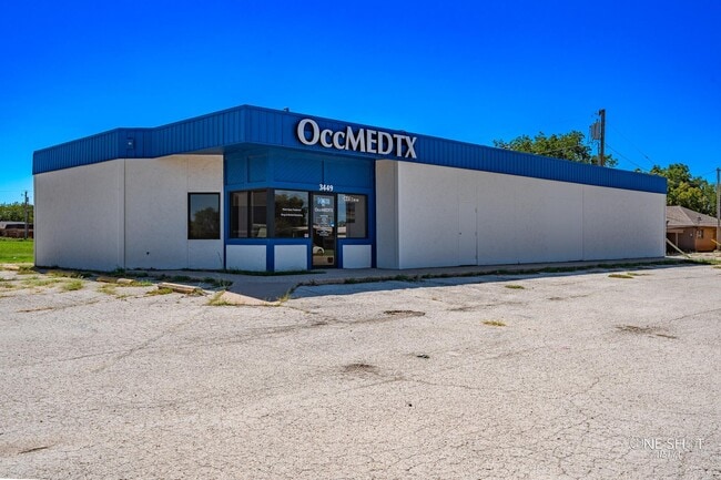
Property Record
3449 N 10Th St, Abilene, TX 79603
NEARBY LISTINGS FOR SALE OR LEASE
Property Detail
3449 N 10Th St
Abilene, TX
Westlawn Addn
52672
WESTLAWN ADDN, BLOCK 12, LOT 308 REP
Multipleuses
Taylor
AE
Texas
48441C0209F
308
2024
0.43 AC
2025
Westwood Richland
011300
Other Market Areas
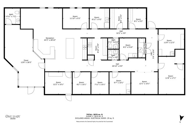
3,047 SF
DEMOGRAPHICS near 3449 N 10Th St
1 Mile
3 Mile
5 Mile
2024 Total Population
12,297
62,181
101,632
2029 Population
12,374
63,933
104,309
Pop Growth 2024-2029
+ 0.63%
+ 2.82%
+ 2.63%
Average Age
37
36
36
2024 Total Households
4,473
23,551
39,192
HH Growth 2024-2029
+ 0.89%
+ 3.06%
+ 2.82%
Median Household Inc
$55,000
$45,623
$49,303
Avg Household Size
2.60
2.50
2.40
2024 Avg HH Vehicles
2.00
2.00
2.00
Median Home Value
$132,088
$109,421
$134,211
Median Year Built
1957
1957
1968
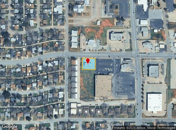
Nearby Places
Map Layers
Map Styles
 Street
 Aerial
- Restaurants
- Banks
- Shops
- Fitness
- Groceries
PUBLIC TRANSPORTATION
AIRPORT
Abilene Regional
DRIVE
WALK
Distance
Abilene Regional
16 min
8.2 mi
Freight Ports
Calhoun Port
DRIVE
WALK
Distance
Calhoun Port
438 min
377.3 mi
SALE & LEASE HISTORY
LISTING DATE
SALE/LEASE

Oct 04, 2024
For Sale
Nearby Properties
Address
Land Use
TOTAL SIZE
Lot Size
Zoning
Address
Land Use
TOTAL SIZE
Lot Size
Zoning
24.36 AC
Address
Land Use
TOTAL SIZE
Lot Size
Zoning
169,821 SF
3.59 AC
Address
Land Use
TOTAL SIZE
Lot Size
Zoning
600,001 SF
39.40 AC
Address
Land Use
TOTAL SIZE
Lot Size
Zoning
183,321 SF
11.67 AC
Address
Land Use
TOTAL SIZE
Lot Size
Zoning
141,777 SF
36.78 AC
Address
Land Use
TOTAL SIZE
Lot Size
Zoning
162,480 SF
9.88 AC
Address
Land Use
TOTAL SIZE
Lot Size
Zoning
95,893 SF
15.89 AC
Address
Land Use
TOTAL SIZE
Lot Size
Zoning
144,349 SF
11.07 AC
Address
Land Use
TOTAL SIZE
Lot Size
Zoning
342,750 SF
34.54 AC
Address
Land Use
TOTAL SIZE
Lot Size
Zoning
176,378 SF
36.99 AC
Address
Land Use
TOTAL SIZE
Lot Size
Zoning
73,947 SF
9.89 AC
Address
Land Use
TOTAL SIZE
Lot Size
Zoning
71,515 SF
9.94 AC
Address
Land Use
TOTAL SIZE
Lot Size
Zoning
75,482 SF
137.60 AC
Address
Land Use
TOTAL SIZE
Lot Size
Zoning
2.63 AC
Address
Land Use
TOTAL SIZE
Lot Size
Zoning
84,335 SF
4.68 AC
Address
Land Use
TOTAL SIZE
Lot Size
Zoning
52,028 SF
3.62 AC
Address
Land Use
TOTAL SIZE
Lot Size
Zoning
161,050 SF
12.18 AC
Address
Land Use
TOTAL SIZE
Lot Size
Zoning
62,823 SF
9.39 AC
Address
Land Use
TOTAL SIZE
Lot Size
Zoning
155,780 SF
18.80 AC
Address
Land Use
TOTAL SIZE
Lot Size
Zoning
9.55 AC
Address
Land Use
TOTAL SIZE
Lot Size
Zoning
2.63 AC
Address
Land Use
TOTAL SIZE
Lot Size
Zoning
150,552 SF
9.72 AC
Address
Land Use
TOTAL SIZE
Lot Size
Zoning
42,509 SF
8.63 AC
Address
Land Use
TOTAL SIZE
Lot Size
Zoning
38,150 SF
3.52 AC
Address
Land Use
TOTAL SIZE
Lot Size
Zoning
54,844 SF
12.70 AC
Address
Land Use
TOTAL SIZE
Lot Size
Zoning
104,728 SF
17.56 AC
Address
Land Use
TOTAL SIZE
Lot Size
Zoning
473,106 SF
4.68 AC
Address
Land Use
TOTAL SIZE
Lot Size
Zoning
115,042 SF
7.68 AC
Address
Land Use
TOTAL SIZE
Lot Size
Zoning
115,808 SF
5.21 AC
Address
Land Use
TOTAL SIZE
Lot Size
Zoning
241,784 SF
24.28 AC
The World's #1 Commercial Real Estate Marketplace
Connect with us
© 2026 CoStar Group
The information above has been obtained from sources believed reliable. While we do not doubt its accuracy we have not verified it and make no guarantee, warranty or representation about it. It is your responsibility to independently confirm its accuracy and completeness. Any projections, opinions, assumptions, or estimates used are for example only and do not represent the current or future performance of the property. The value of this transaction to you depends on tax and other factors which should be evaluated by your tax, financial, and legal advisors. You and your advisors should conduct a careful, independent investigation of the property to determine to your satisfaction the suitability of the property for your needs.