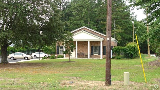
Property Record
3449 Sunset Blvd, West Columbia, SC 29169


Current Lease Availabilities
NEARBY LISTINGS FOR SALE OR LEASE
Property Detail
3449 Sunset Blvd
Multipleuses
Lexington
X
South Carolina
45063C0144J
1.27 AC
2025
Cayce/West Columbia
2024
Columbia
020506
Columbia, SC
1,922 SF
004596-08-017
DEMOGRAPHICS near 3449 Sunset Blvd
1 Mile
3 Mile
5 Mile
2024 Total Population
3,546
43,996
128,653
2029 Population
3,875
47,579
137,256
Pop Growth 2024-2029
+ 9.28%
+ 8.14%
+ 6.69%
Average Age
43
40
39
2024 Total Households
1,640
19,122
55,466
HH Growth 2024-2029
+ 9.51%
+ 8.21%
+ 6.87%
Median Household Inc
$65,500
$58,922
$56,268
Avg Household Size
2.10
2.20
2.20
2024 Avg HH Vehicles
2.00
2.00
2.00
Median Home Value
$173,889
$169,600
$167,580
Median Year Built
1988
1980
1980
Nearby Places
Map Layers
Map Styles
 Street
 Aerial
- Restaurants
- Banks
- Shops
- Fitness
- Groceries
PUBLIC TRANSPORTATION
COMMUTER RAIL
Columbia Amtrak Station (Silver Star - Amtrak)
DRIVE
WALK
Distance
Columbia Amtrak Station (Silver Star - Amtrak)
10 min
5.7 mi
AIRPORT
Columbia Metro
DRIVE
WALK
Distance
Columbia Metro
19 min
9.0 mi
Freight Ports
North Charleston Terminal
DRIVE
WALK
Distance
North Charleston Terminal
119 min
105.2 mi
Nearby Properties
Address
Land Use
TOTAL SIZE
Lot Size
Zoning
Address
Land Use
TOTAL SIZE
Lot Size
Zoning
128,160 SF
9.31 AC
RM-HD
Address
Land Use
TOTAL SIZE
Lot Size
Zoning
358,561 SF
42.10 AC
EC
Address
Land Use
TOTAL SIZE
Lot Size
Zoning
183,392 SF
14.77 AC
RM-HD
Address
Land Use
TOTAL SIZE
Lot Size
Zoning
129,108 SF
11.90 AC
RM-HD
Address
Land Use
TOTAL SIZE
Lot Size
Zoning
204,968 SF
17.39 AC
RM-HD
Address
Land Use
TOTAL SIZE
Lot Size
Zoning
89,376 SF
6.85 AC
CAC
Address
Land Use
TOTAL SIZE
Lot Size
Zoning
44,296 SF
14.01 AC
GC
Address
Land Use
TOTAL SIZE
Lot Size
Zoning
82,874 SF
6.99 AC
GC
Address
Land Use
TOTAL SIZE
Lot Size
Zoning
151,470 SF
8.44 AC
RM-2
Address
Land Use
TOTAL SIZE
Lot Size
Zoning
81,900 SF
4.95 AC
EC
Address
Land Use
TOTAL SIZE
Lot Size
Zoning
78,288 SF
5.14 AC
GC
Address
Land Use
TOTAL SIZE
Lot Size
Zoning
208,016 SF
14.28 AC
GC
Address
Land Use
TOTAL SIZE
Lot Size
Zoning
282,660 SF
41.39 AC
RAC
Address
Land Use
TOTAL SIZE
Lot Size
Zoning
70,000 SF
11.32 AC
LI
Address
Land Use
TOTAL SIZE
Lot Size
Zoning
42,072 SF
2.01 AC
GC
Address
Land Use
TOTAL SIZE
Lot Size
Zoning
93,384 SF
7.24 AC
EC
Address
Land Use
TOTAL SIZE
Lot Size
Zoning
3.29 AC
OI
Address
Land Use
TOTAL SIZE
Lot Size
Zoning
40,800 SF
7 AC
CAC
Address
Land Use
TOTAL SIZE
Lot Size
Zoning
66,640 SF
3.47 AC
EC
Address
Land Use
TOTAL SIZE
Lot Size
Zoning
66,640 SF
3.45 AC
GC
Address
Land Use
TOTAL SIZE
Lot Size
Zoning
77,016 SF
5.05 AC
GC
Address
Land Use
TOTAL SIZE
Lot Size
Zoning
25,700 SF
11.43 AC
RSF-1
Address
Land Use
TOTAL SIZE
Lot Size
Zoning
131,078 SF
12.55 AC
RM-HD
Address
Land Use
TOTAL SIZE
Lot Size
Zoning
36,369 SF
4.97 AC
OI
Address
Land Use
TOTAL SIZE
Lot Size
Zoning
70,713 SF
8.64 AC
GC
Address
Land Use
TOTAL SIZE
Lot Size
Zoning
58,664 SF
6.01 AC
Address
Land Use
TOTAL SIZE
Lot Size
Zoning
31,892 SF
2.23 AC
GC
Address
Land Use
TOTAL SIZE
Lot Size
Zoning
21,475 SF
4.97 AC
GC
Address
Land Use
TOTAL SIZE
Lot Size
Zoning
93,736 SF
9.88 AC
GC
Address
Land Use
TOTAL SIZE
Lot Size
Zoning
32,144 SF
2.01 AC
GC
The World's #1 Commercial Real Estate Marketplace
Connect with us
© 2025 CoStar Group
The information above has been obtained from sources believed reliable. While we do not doubt its accuracy we have not verified it and make no guarantee, warranty or representation about it. It is your responsibility to independently confirm its accuracy and completeness. Any projections, opinions, assumptions, or estimates used are for example only and do not represent the current or future performance of the property. The value of this transaction to you depends on tax and other factors which should be evaluated by your tax, financial, and legal advisors. You and your advisors should conduct a careful, independent investigation of the property to determine to your satisfaction the suitability of the property for your needs.