Property Record
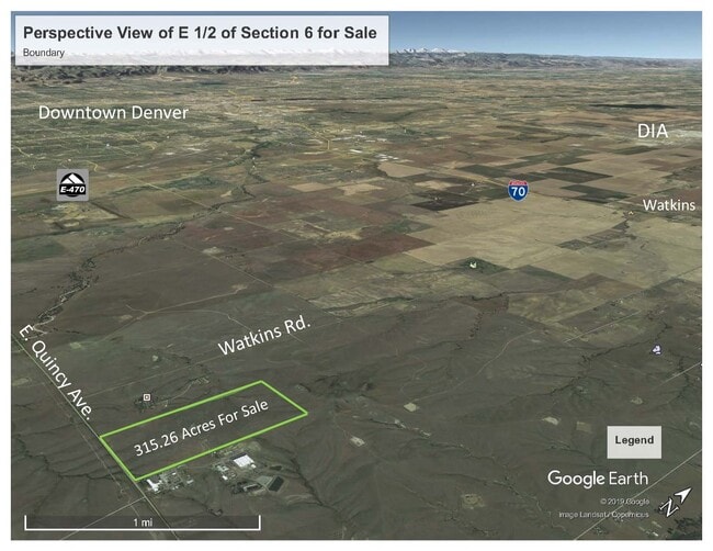
34495 E Quincy Ave, Watkins, CO 80137
NEARBY LISTINGS FOR SALE OR LEASE
-
-
View all Watkins listings for sale on LoopNet.com
Property Detail
34495 E Quincy Ave
2069-00-0-00-143
SECTION 06 TOWNSHIP 05 RANGE 64 THE S 12 OF THE NE 14 & THE SE 14 OF SEC 6-5-64 EX 2 USA OWNED TRACTS MEASURING 100FT X 100FT & EX THAT PART OF REC# D8040080 DESC AS BEG 55 FT N OF SW 14 OF SEC 5-5-64 TH W 20.08 FT TH N 68.52 FT TH W 27.16 FT TH N 80
Pasture
Arapahoe
X
Colorado
08005C0240M
233.99 AC
2023
Outlying Arapahoe County
2024
Denver
007103
Denver-Aurora-Lakewood, CO
DEMOGRAPHICS near 34495 E Quincy Ave
1 Mile
3 Mile
5 Mile
2024 Total Population
6
63
646
2029 Population
6
64
648
Pop Growth 2024-2029
0.00%
+ 1.59%
+ 0.31%
Average Age
45
40
41
2024 Total Households
2
20
209
HH Growth 2024-2029
0.00%
+ 5.00%
0.00%
Median Household Inc
$300,000
$131,250
$140,234
Avg Household Size
3.00
2.90
3.00
2024 Avg HH Vehicles
2.00
3.00
3.00
Median Home Value
$750,000
$687,500
$740,942
Median Year Built
2010
2002
2000
Nearby Places
- Restaurants
- Banks
- Shops
- Fitness
- Groceries
PUBLIC TRANSPORTATION
AIRPORT
Denver International
DRIVE
WALK
Distance
Denver International
40 min
26.5 mi
SALE & LEASE HISTORY
LISTING DATE
SALE/LEASE

Dec 10, 2019
For Sale
Nearby Properties
Address
Land Use
TOTAL SIZE
Lot Size
Zoning
Address
Land Use
TOTAL SIZE
Lot Size
Zoning
323,965 SF
104.65 AC
AI2
Address
Land Use
TOTAL SIZE
Lot Size
Zoning
98,618 SF
636.52 AC
Address
Land Use
TOTAL SIZE
Lot Size
Zoning
2,850 SF
112.86 AC
AI2
Address
Land Use
TOTAL SIZE
Lot Size
Zoning
35.26 AC
AAE
Address
Land Use
TOTAL SIZE
Lot Size
Zoning
6,130 SF
40.23 AC
AA1
Address
Land Use
TOTAL SIZE
Lot Size
Zoning
1,499 SF
20.77 AC
AA1
Address
Land Use
TOTAL SIZE
Lot Size
Zoning
5,712 SF
40 AC
AA1
Address
Land Use
TOTAL SIZE
Lot Size
Zoning
3,156 SF
39.09 AC
AA1
Address
Land Use
TOTAL SIZE
Lot Size
Zoning
2,053 SF
40.81 AC
AA1
Address
Land Use
TOTAL SIZE
Lot Size
Zoning
4,375 SF
40 AC
AA1
Address
Land Use
TOTAL SIZE
Lot Size
Zoning
2,964 SF
40.08 AC
AA1
Address
Land Use
TOTAL SIZE
Lot Size
Zoning
3,360 SF
1 AC
Address
Land Use
TOTAL SIZE
Lot Size
Zoning
321.24 AC
Address
Land Use
TOTAL SIZE
Lot Size
Zoning
2,862 SF
20.38 AC
AA1
Address
Land Use
TOTAL SIZE
Lot Size
Zoning
2,196 SF
19.86 AC
AA1
Address
Land Use
TOTAL SIZE
Lot Size
Zoning
1,920 SF
20.20 AC
AA1
Address
Land Use
TOTAL SIZE
Lot Size
Zoning
672 SF
39.34 AC
AA1
Address
Land Use
TOTAL SIZE
Lot Size
Zoning
2,696 SF
40.07 AC
AA1
Address
Land Use
TOTAL SIZE
Lot Size
Zoning
40.65 AC
AA1
Address
Land Use
TOTAL SIZE
Lot Size
Zoning
623.86 AC
AA1
Address
Land Use
TOTAL SIZE
Lot Size
Zoning
311.11 AC
AA1
Address
Land Use
TOTAL SIZE
Lot Size
Zoning
292.65 AC
AAE
Address
Land Use
TOTAL SIZE
Lot Size
Zoning
318.18 AC
Address
Land Use
TOTAL SIZE
Lot Size
Zoning
640.68 AC
AA1
Address
Land Use
TOTAL SIZE
Lot Size
Zoning
Address
Land Use
TOTAL SIZE
Lot Size
Zoning
52.22 AC
AAE
Address
Land Use
TOTAL SIZE
Lot Size
Zoning
40.29 AC
AA1
Address
Land Use
TOTAL SIZE
Lot Size
Zoning
39.99 AC
AA1
The World's #1 Commercial Real Estate Marketplace
Connect with us
© 2025 CoStar Group
The information above has been obtained from sources believed reliable. While we do not doubt its accuracy we have not verified it and make no guarantee, warranty or representation about it. It is your responsibility to independently confirm its accuracy and completeness. Any projections, opinions, assumptions, or estimates used are for example only and do not represent the current or future performance of the property. The value of this transaction to you depends on tax and other factors which should be evaluated by your tax, financial, and legal advisors. You and your advisors should conduct a careful, independent investigation of the property to determine to your satisfaction the suitability of the property for your needs.