Property Record
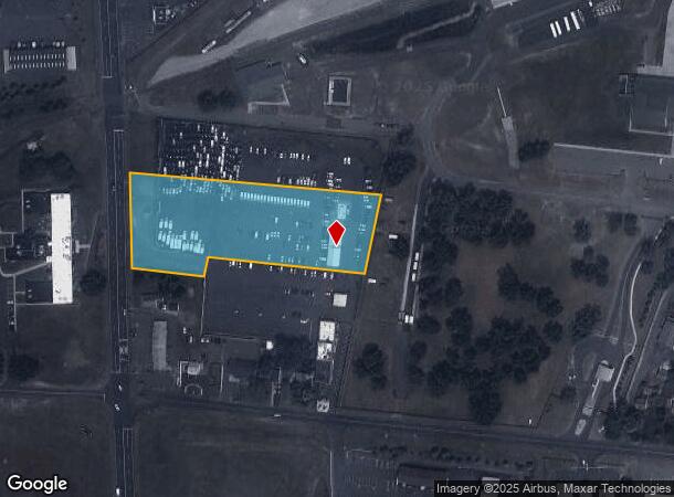
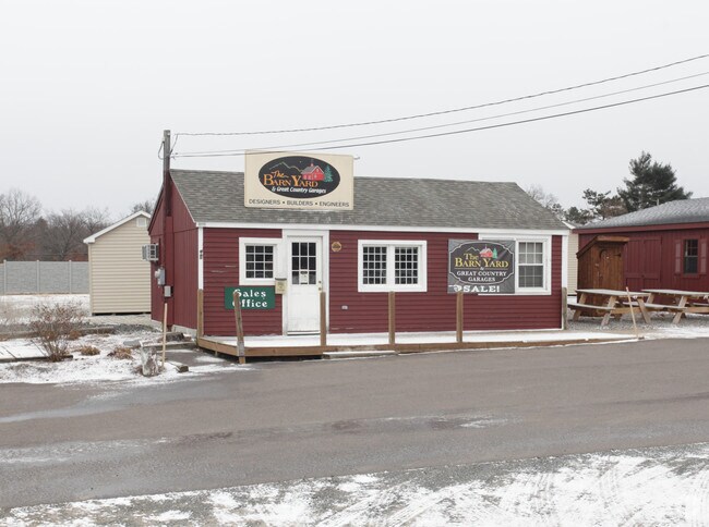
345 Ella Grasso Tpke, Windsor Locks, CT 06096

NEARBY LISTINGS FOR SALE OR LEASE
Property Detail
345 Ella Grasso Tpke
WINL-000009-000002-000312
Hartford
Commercialacreage
Connecticut
X
312
09003C0208F
5.57 AC
2024
Windsor Locks
2025
Hartford
476100
Hartford-West Hartford-East Hartford, CT
3,000 SF
DEMOGRAPHICS near 345 Ella Grasso Tpke
1 Mile
3 Mile
5 Mile
2024 Total Population
1,191
19,430
49,310
2029 Population
1,183
19,332
49,167
Pop Growth 2024-2029
(0.67%)
(0.50%)
(0.29%)
Average Age
44
44
43
2024 Total Households
480
8,260
19,844
HH Growth 2024-2029
(0.63%)
(0.56%)
(0.43%)
Median Household Inc
$94,473
$86,660
$90,264
Avg Household Size
2.40
2.30
2.30
2024 Avg HH Vehicles
2.00
2.00
2.00
Median Home Value
$221,642
$258,490
$271,255
Median Year Built
1963
1967
1972
Nearby Places
Map Layers
Map Styles
 Street
 Aerial
- Restaurants
- Banks
- Shops
- Fitness
- Groceries
PUBLIC TRANSPORTATION
COMMUTER RAIL
Windsor Locks (Hartford Line - CT Rail (CTRail))
DRIVE
WALK
Distance
Windsor Locks (Hartford Line - CT Rail (CTRail))
8 min
4.0 mi
Windsor (Amtrak Hartford Line - Amtrak, Hartford Line - Amtrak, Northeast Regional - Amtrak, Valley Flyer - Amtrak)
DRIVE
WALK
Distance
Windsor (Amtrak Hartford Line - Amtrak, Hartford Line - Amtrak, Northeast Regional - Amtrak, Valley Flyer - Amtrak)
16 min
9.4 mi
AIRPORT
Bradley International
DRIVE
WALK
Distance
Bradley International
12 min
3.4 mi
Freight Ports
Port of New Haven
DRIVE
WALK
Distance
Port of New Haven
71 min
53.2 mi
Nearby Properties
Address
Land Use
TOTAL SIZE
Lot Size
Zoning
Address
Land Use
TOTAL SIZE
Lot Size
Zoning
723,830 SF
160.79 AC
IND1
Address
Land Use
TOTAL SIZE
Lot Size
Zoning
Address
Land Use
TOTAL SIZE
Lot Size
Zoning
207,981 SF
60.48 AC
R45
Address
Land Use
TOTAL SIZE
Lot Size
Zoning
130.99 AC
Address
Land Use
TOTAL SIZE
Lot Size
Zoning
6,000 SF
62.78 AC
IND1
Address
Land Use
TOTAL SIZE
Lot Size
Zoning
64.41 AC
IND3
Address
Land Use
TOTAL SIZE
Lot Size
Zoning
64,798 SF
1 AC
Address
Land Use
TOTAL SIZE
Lot Size
Zoning
143,800 SF
Address
Land Use
TOTAL SIZE
Lot Size
Zoning
269,325 SF
32.33 AC
IND3
Address
Land Use
TOTAL SIZE
Lot Size
Zoning
123,229 SF
4.08 AC
MFSD
Address
Land Use
TOTAL SIZE
Lot Size
Zoning
177,366 SF
61.60 AC
RESA
Address
Land Use
TOTAL SIZE
Lot Size
Zoning
334,788 SF
40.37 AC
IND3
Address
Land Use
TOTAL SIZE
Lot Size
Zoning
52,811 SF
4.79 AC
BUS1
Address
Land Use
TOTAL SIZE
Lot Size
Zoning
12.14 AC
I
Address
Land Use
TOTAL SIZE
Lot Size
Zoning
2,867 SF
17.27 AC
R-2
Address
Land Use
TOTAL SIZE
Lot Size
Zoning
234,000 SF
16.50 AC
Address
Land Use
TOTAL SIZE
Lot Size
Zoning
124,964 SF
RESA
Address
Land Use
TOTAL SIZE
Lot Size
Zoning
Address
Land Use
TOTAL SIZE
Lot Size
Zoning
21.50 AC
R25
Address
Land Use
TOTAL SIZE
Lot Size
Zoning
451,937 SF
25.93 AC
IND3
Address
Land Use
TOTAL SIZE
Lot Size
Zoning
14,295 SF
24.45 AC
R-1
Address
Land Use
TOTAL SIZE
Lot Size
Zoning
14,864 SF
0.25 AC
IND1
Address
Land Use
TOTAL SIZE
Lot Size
Zoning
15.58 AC
RESA
Address
Land Use
TOTAL SIZE
Lot Size
Zoning
50,287 SF
1.74 AC
Address
Land Use
TOTAL SIZE
Lot Size
Zoning
243,624 SF
12.16 AC
I
Address
Land Use
TOTAL SIZE
Lot Size
Zoning
46,206 SF
2.70 AC
BUS1
Address
Land Use
TOTAL SIZE
Lot Size
Zoning
226,546 SF
16.40 AC
IND3
Address
Land Use
TOTAL SIZE
Lot Size
Zoning
80,408 SF
2.59 AC
BUS1
Address
Land Use
TOTAL SIZE
Lot Size
Zoning
260,002 SF
9.89 AC
IND3
Address
Land Use
TOTAL SIZE
Lot Size
Zoning
The World's #1 Commercial Real Estate Marketplace
Connect with us
© 2026 CoStar Group
The information above has been obtained from sources believed reliable. While we do not doubt its accuracy we have not verified it and make no guarantee, warranty or representation about it. It is your responsibility to independently confirm its accuracy and completeness. Any projections, opinions, assumptions, or estimates used are for example only and do not represent the current or future performance of the property. The value of this transaction to you depends on tax and other factors which should be evaluated by your tax, financial, and legal advisors. You and your advisors should conduct a careful, independent investigation of the property to determine to your satisfaction the suitability of the property for your needs.