No Photo
Property Record
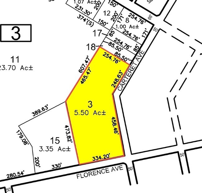
345 Florence Ave, Pitman, NJ 08071

Property Detail
345 Florence Ave
02-00003-0000-00003
GLOUCESTER
Vacantlandnec
New Jersey
RM2
3
B and X Area of moderate flood hazard, usually the area between the limits of the 100-year and 500-year floods.
5.66 AC
2024
Gloucester County
2025
Philadelphia
501302
Philadelphia-Camden-Wilmington, PA-NJ-DE-MD
NEARBY LISTINGS FOR SALE OR LEASE
DEMOGRAPHICS near 345 Florence Ave
1 mile
3 mile
5 mile
2025 Total Population
9,755
75,150
228,133
2030 Population
10,013
76,899
231,977
Pop Growth 2025-2030
+ 2.64%
+ 2.33%
+ 1.68%
Average Age
41
41
41
2025 Total Households
4,056
30,085
90,840
HH Growth 2025-2030
+ 2.54%
+ 2.31%
+ 1.69%
Median Household Inc
$69,325
$80,654
$83,541
Avg Household Size
2.40
2.40
2.50
2025 Avg HH Vehicles
2.00
2.00
2.00
Median Home Value
$218,405
$247,963
$273,609
Median Year Built
1963
1959
1958
Nearby Places
Map Layers
Map Styles
 Street
 Aerial
Layers
 Traffic
 Biking
Places
Listings with unknown addresses are not visible on the map
- Restaurants
- Banks
- Shops
- Fitness
- Groceries
PUBLIC TRANSPORTATION
COMMUTER RAIL
Cherry Hill (Atlantic City Line - NJ Transit Commuter Rail (NJ Transit))
Drive
Walk
Distance
Cherry Hill (Atlantic City Line - NJ Transit Commuter Rail (NJ Transit))
16 min
9.3 mi
Lindenwold (NJT) (Atlantic City Line - NJ Transit Commuter Rail (NJ Transit))
Drive
Walk
Distance
Lindenwold (NJT) (Atlantic City Line - NJ Transit Commuter Rail (NJ Transit))
15 min
9.6 mi
AIRPORT
Philadelphia International
Drive
Walk
Distance
Philadelphia International
27 min
14.6 mi
Trenton Mercer
Drive
Walk
Distance
Trenton Mercer
61 min
41.6 mi
Atlantic City International
Drive
Walk
Distance
Atlantic City International
81 min
46.8 mi
Freight Ports
Broadway Terminal - Pier 5
Drive
Walk
Distance
Broadway Terminal - Pier 5
11 min
4.7 mi
SALE & LEASE HISTORY
LISTING DATE
SALE/LEASE

Sep 24, 2016
For Sale
May 17, 2017
For Sale
Nearby Properties
Address
Land Use
TOTAL SIZE
Lot Size
Zoning
Address
Land Use
TOTAL SIZE
Lot Size
Zoning
23.41 AC
BC2
Address
Land Use
TOTAL SIZE
Lot Size
Zoning
810.21 AC
0108
Address
Land Use
TOTAL SIZE
Lot Size
Zoning
1.66 AC
R01
Address
Land Use
TOTAL SIZE
Lot Size
Zoning
30.63 AC
R10
Address
Land Use
TOTAL SIZE
Lot Size
Zoning
40.92 AC
BC2
Address
Land Use
TOTAL SIZE
Lot Size
Zoning
78.64 AC
Address
Land Use
TOTAL SIZE
Lot Size
Zoning
25.77 AC
R10
Address
Land Use
TOTAL SIZE
Lot Size
Zoning
27.25 AC
Address
Land Use
TOTAL SIZE
Lot Size
Zoning
67.33 AC
BC2
Address
Land Use
TOTAL SIZE
Lot Size
Zoning
57.58 AC
C
Address
Land Use
TOTAL SIZE
Lot Size
Zoning
Address
Land Use
TOTAL SIZE
Lot Size
Zoning
32.20 AC
R-1
Address
Land Use
TOTAL SIZE
Lot Size
Zoning
21.32 AC
Address
Land Use
TOTAL SIZE
Lot Size
Zoning
132.57 AC
M2
Address
Land Use
TOTAL SIZE
Lot Size
Zoning
29.23 AC
BC3
Address
Land Use
TOTAL SIZE
Lot Size
Zoning
Address
Land Use
TOTAL SIZE
Lot Size
Zoning
15.96 AC
BC2
Address
Land Use
TOTAL SIZE
Lot Size
Zoning
Address
Land Use
TOTAL SIZE
Lot Size
Zoning
14.49 AC
BC2
Address
Land Use
TOTAL SIZE
Lot Size
Zoning
31.57 AC
RM2
Address
Land Use
TOTAL SIZE
Lot Size
Zoning
3.22 AC
PA
Address
Land Use
TOTAL SIZE
Lot Size
Zoning
8.58 AC
BC2
Address
Land Use
TOTAL SIZE
Lot Size
Zoning
1,228 SF
7.69 AC
Address
Land Use
TOTAL SIZE
Lot Size
Zoning
1.11 AC
R4
Address
Land Use
TOTAL SIZE
Lot Size
Zoning
2.82 AC
BC2
Address
Land Use
TOTAL SIZE
Lot Size
Zoning
3.01 AC
Address
Land Use
TOTAL SIZE
Lot Size
Zoning
14.19 AC
BC2
Address
Land Use
TOTAL SIZE
Lot Size
Zoning
21.81 AC
RM2
Address
Land Use
TOTAL SIZE
Lot Size
Zoning
612.07 AC
Address
Land Use
TOTAL SIZE
Lot Size
Zoning
13.49 AC
BC2
The World's #1 Commercial Real Estate Marketplace
Connect with us
© 2026 CoStar Group
The information above has been obtained from sources believed reliable. While we do not doubt its accuracy we have not verified it and make no guarantee, warranty or representation about it. It is your responsibility to independently confirm its accuracy and completeness. Any projections, opinions, assumptions, or estimates used are for example only and do not represent the current or future performance of the property. The value of this transaction to you depends on tax and other factors which should be evaluated by your tax, financial, and legal advisors. You and your advisors should conduct a careful, independent investigation of the property to determine to your satisfaction the suitability of the property for your needs.