Property Record
345 Greenwood St, Worcester, MA 01607
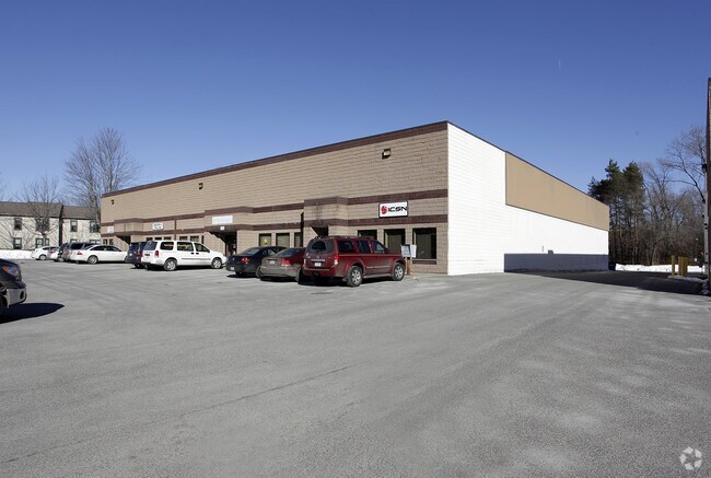

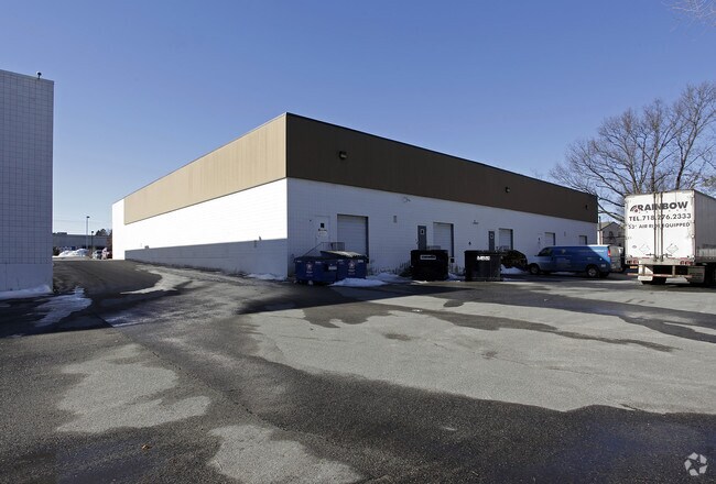
Property Detail
345 Greenwood St
WORC-000029-000047-000008
Worcester
Industrialgeneral
Massachusetts
ML-.5
8
B and X Area of moderate flood hazard, usually the area between the limits of the 100-year and 500-year floods.
1.46 AC
2025
Worcester Metro
2025
Boston
732901
Worcester, MA
24,750 SF
NEARBY LISTINGS FOR SALE OR LEASE
DEMOGRAPHICS near 345 Greenwood St
1 mile
3 mile
5 mile
2025 Total Population
5,107
84,731
197,558
2030 Population
5,278
86,046
200,282
Pop Growth 2025-2030
+ 3.35%
+ 1.55%
+ 1.38%
Average Age
41
39
39
2025 Total Households
2,164
33,604
78,158
HH Growth 2025-2030
+ 3.47%
+ 1.73%
+ 1.51%
Median Household Inc
$65,451
$74,600
$74,464
Avg Household Size
2.30
2.40
2.40
2025 Avg HH Vehicles
2.00
2.00
2.00
Median Home Value
$382,394
$379,486
$399,489
Median Year Built
1965
1949
1952
Nearby Places
Map Layers
Map Styles
 Street
 Aerial
Transit
 Traffic
 Biking
Places
Listings with unknown addresses are not visible on the map
- Restaurants
- Banks
- Shops
- Fitness
- Groceries
PUBLIC TRANSPORTATION
COMMUTER RAIL
Worcester Union Station (Lake Shore Limited - Amtrak)
Drive
Walk
Distance
Worcester Union Station (Lake Shore Limited - Amtrak)
8 min
3.8 mi
Worcester (Framingham/Worcester Line - Massachusetts Bay Transportation Authority Commuter Rail (Purple Line))
Drive
Walk
Distance
Worcester (Framingham/Worcester Line - Massachusetts Bay Transportation Authority Commuter Rail (Purple Line))
8 min
3.9 mi
AIRPORT
Worcester Regional
Drive
Walk
Distance
Worcester Regional
18 min
9.2 mi
Freight Ports
Port of Boston
Drive
Walk
Distance
Port of Boston
58 min
44.1 mi
SALE & LEASE HISTORY
LISTING DATE
SALE/LEASE

Sep 25, 2016
For Lease
Nearby Properties
Address
Land Use
TOTAL SIZE
Lot Size
Zoning
Address
Land Use
TOTAL SIZE
Lot Size
Zoning
142.98 AC
Address
Land Use
TOTAL SIZE
Lot Size
Zoning
25,000 SF
99.10 AC
MG-.5
Address
Land Use
TOTAL SIZE
Lot Size
Zoning
311,604 SF
2.37 AC
MG-2
Address
Land Use
TOTAL SIZE
Lot Size
Zoning
1,760 SF
105.54 AC
ML10
Address
Land Use
TOTAL SIZE
Lot Size
Zoning
164,378 SF
21.40 AC
Address
Land Use
TOTAL SIZE
Lot Size
Zoning
19,319 SF
10.67 AC
RG-5
Address
Land Use
TOTAL SIZE
Lot Size
Zoning
591,515 SF
33.04 AC
MG-1
Address
Land Use
TOTAL SIZE
Lot Size
Zoning
3.55 AC
RG-5
Address
Land Use
TOTAL SIZE
Lot Size
Zoning
210,168 SF
45.75 AC
RL-7
Address
Land Use
TOTAL SIZE
Lot Size
Zoning
69.46 AC
RS-7
Address
Land Use
TOTAL SIZE
Lot Size
Zoning
159,355 SF
207.62 AC
RL-7
Address
Land Use
TOTAL SIZE
Lot Size
Zoning
3.43 AC
ML10
Address
Land Use
TOTAL SIZE
Lot Size
Zoning
27.89 AC
RL-7
Address
Land Use
TOTAL SIZE
Lot Size
Zoning
78.19 AC
RL-7
Address
Land Use
TOTAL SIZE
Lot Size
Zoning
7,700 SF
80.72 AC
ML-.5
Address
Land Use
TOTAL SIZE
Lot Size
Zoning
36.67 AC
Address
Land Use
TOTAL SIZE
Lot Size
Zoning
53.52 AC
RL-7
Address
Land Use
TOTAL SIZE
Lot Size
Zoning
2.78 AC
MG-2
Address
Land Use
TOTAL SIZE
Lot Size
Zoning
222,474 SF
22.75 AC
MG-1
Address
Land Use
TOTAL SIZE
Lot Size
Zoning
279,977 SF
17.80 AC
Address
Land Use
TOTAL SIZE
Lot Size
Zoning
200 SF
50.14 AC
MG-2
Address
Land Use
TOTAL SIZE
Lot Size
Zoning
187,280 SF
1.22 AC
BG-4
Address
Land Use
TOTAL SIZE
Lot Size
Zoning
153,745 SF
10.99 AC
MG-2
Address
Land Use
TOTAL SIZE
Lot Size
Zoning
92,604 SF
1 AC
Address
Land Use
TOTAL SIZE
Lot Size
Zoning
210,001 SF
13.14 AC
Address
Land Use
TOTAL SIZE
Lot Size
Zoning
70,400 SF
17.10 AC
Address
Land Use
TOTAL SIZE
Lot Size
Zoning
8.77 AC
BL-1
Address
Land Use
TOTAL SIZE
Lot Size
Zoning
153,510 SF
1.67 AC
RG-5
Address
Land Use
TOTAL SIZE
Lot Size
Zoning
151.20 AC
Address
Land Use
TOTAL SIZE
Lot Size
Zoning
133,482 SF
15.80 AC
BG-2
The World's #1 Commercial Real Estate Marketplace
Connect with us
© 2026 CoStar Group
The information above has been obtained from sources believed reliable. While we do not doubt its accuracy we have not verified it and make no guarantee, warranty or representation about it. It is your responsibility to independently confirm its accuracy and completeness. Any projections, opinions, assumptions, or estimates used are for example only and do not represent the current or future performance of the property. The value of this transaction to you depends on tax and other factors which should be evaluated by your tax, financial, and legal advisors. You and your advisors should conduct a careful, independent investigation of the property to determine to your satisfaction the suitability of the property for your needs.