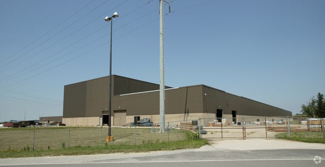
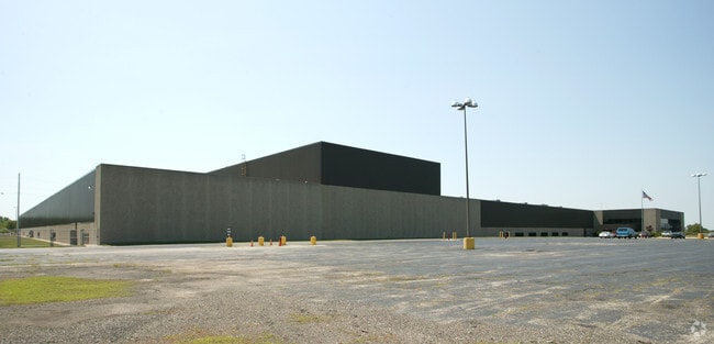
Property Record
345 Harvestore Dr, Dekalb, IL 60115
NEARBY LISTINGS FOR SALE OR LEASE
Property Detail
345 Harvestore Dr
Chicago-Naperville-Elgin, IL-IN-WI
PT E 1/2 - SEC 34 - T40N R5E
08-34-276-009
DeKalb
Industrialgeneral
Illinois
2023
57.46 AC
2024
Central Kane / DuPage
001400
Chicago
DEMOGRAPHICS near 345 Harvestore Dr
1 Mile
3 Mile
5 Mile
2024 Total Population
2,404
26,776
48,748
2029 Population
2,371
26,731
48,812
Pop Growth 2024-2029
(1.37%)
(0.17%)
+ 0.13%
Average Age
42
34
34
2024 Total Households
891
10,335
18,591
HH Growth 2024-2029
(1.57%)
+ 0.08%
+ 0.24%
Median Household Inc
$69,230
$48,945
$50,730
Avg Household Size
2.60
2.30
2.30
2024 Avg HH Vehicles
2.00
2.00
2.00
Median Home Value
$163,048
$167,983
$175,659
Median Year Built
1988
1973
1978
Nearby Places
Map Layers
Map Styles
 Street
 Aerial
- Restaurants
- Banks
- Shops
- Fitness
- Groceries
PUBLIC TRANSPORTATION
AIRPORT
Chicago/Rockford International
DRIVE
WALK
Distance
Chicago/Rockford International
53 min
38.7 mi
Freight Ports
Port Milwaukee
DRIVE
WALK
Distance
Port Milwaukee
146 min
104.7 mi
Nearby Properties
Address
Land Use
TOTAL SIZE
Lot Size
Zoning
Address
Land Use
TOTAL SIZE
Lot Size
Zoning
227.72 AC
Address
Land Use
TOTAL SIZE
Lot Size
Zoning
71.90 AC
Address
Land Use
TOTAL SIZE
Lot Size
Zoning
49.71 AC
Address
Land Use
TOTAL SIZE
Lot Size
Zoning
58.65 AC
Address
Land Use
TOTAL SIZE
Lot Size
Zoning
33.65 AC
Address
Land Use
TOTAL SIZE
Lot Size
Zoning
49.73 AC
Address
Land Use
TOTAL SIZE
Lot Size
Zoning
98.56 AC
Address
Land Use
TOTAL SIZE
Lot Size
Zoning
43.10 AC
Address
Land Use
TOTAL SIZE
Lot Size
Zoning
94.65 AC
Address
Land Use
TOTAL SIZE
Lot Size
Zoning
47.87 AC
Address
Land Use
TOTAL SIZE
Lot Size
Zoning
257.54 AC
Address
Land Use
TOTAL SIZE
Lot Size
Zoning
21.61 AC
Address
Land Use
TOTAL SIZE
Lot Size
Zoning
15.79 AC
Address
Land Use
TOTAL SIZE
Lot Size
Zoning
25.70 AC
Address
Land Use
TOTAL SIZE
Lot Size
Zoning
9.39 AC
Address
Land Use
TOTAL SIZE
Lot Size
Zoning
21.35 AC
Address
Land Use
TOTAL SIZE
Lot Size
Zoning
9.04 AC
Address
Land Use
TOTAL SIZE
Lot Size
Zoning
9.88 AC
Address
Land Use
TOTAL SIZE
Lot Size
Zoning
11.50 AC
Address
Land Use
TOTAL SIZE
Lot Size
Zoning
0.05 AC
Address
Land Use
TOTAL SIZE
Lot Size
Zoning
13.48 AC
Address
Land Use
TOTAL SIZE
Lot Size
Zoning
7.41 AC
Address
Land Use
TOTAL SIZE
Lot Size
Zoning
5.59 AC
Address
Land Use
TOTAL SIZE
Lot Size
Zoning
8.78 AC
Address
Land Use
TOTAL SIZE
Lot Size
Zoning
Address
Land Use
TOTAL SIZE
Lot Size
Zoning
0.48 AC
Address
Land Use
TOTAL SIZE
Lot Size
Zoning
11.28 AC
Address
Land Use
TOTAL SIZE
Lot Size
Zoning
Address
Land Use
TOTAL SIZE
Lot Size
Zoning
The World's #1 Commercial Real Estate Marketplace
Connect with us
© 2025 CoStar Group
The information above has been obtained from sources believed reliable. While we do not doubt its accuracy we have not verified it and make no guarantee, warranty or representation about it. It is your responsibility to independently confirm its accuracy and completeness. Any projections, opinions, assumptions, or estimates used are for example only and do not represent the current or future performance of the property. The value of this transaction to you depends on tax and other factors which should be evaluated by your tax, financial, and legal advisors. You and your advisors should conduct a careful, independent investigation of the property to determine to your satisfaction the suitability of the property for your needs.