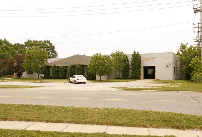
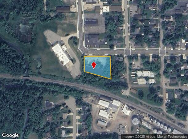
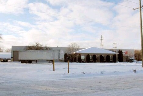
Property Record
345 W Frank St, Fowlerville, MI 48836
NEARBY LISTINGS FOR SALE OR LEASE
Property Detail
345 W Frank St
Detroit-Warren-Dearborn, MI
Village Of Fowlerville
05-10-402-008
SEC 10 T3N R3E VILLAGE OF FOWLERVILLE, ASSESSORS PLAT OF COM- MERCIAL ADDITION, LOT 15 AKA: 345 W FRANK
Industrialgeneral
Livingston
X
Michigan
26093C0162D
15
2025
0.98 AC
2025
Livingston County
722300
Detroit
10,250 SF
DEMOGRAPHICS near 345 W Frank St
1 Mile
3 Mile
5 Mile
2024 Total Population
2,948
8,071
15,029
2029 Population
3,014
8,276
15,329
Pop Growth 2024-2029
+ 2.24%
+ 2.54%
+ 2.00%
Average Age
40
40
40
2024 Total Households
1,258
3,079
5,620
HH Growth 2024-2029
+ 2.23%
+ 2.47%
+ 1.92%
Median Household Inc
$54,356
$68,533
$75,442
Avg Household Size
2.30
2.60
2.60
2024 Avg HH Vehicles
1.00
2.00
2.00
Median Home Value
$139,805
$192,438
$211,103
Median Year Built
1967
1984
1986
Nearby Places
Map Layers
Map Styles
 Street
 Aerial
- Restaurants
- Banks
- Shops
- Fitness
- Groceries
PUBLIC TRANSPORTATION
AIRPORT
Capital Region International
DRIVE
WALK
Distance
Capital Region International
44 min
33.1 mi
Bishop International
DRIVE
WALK
Distance
Bishop International
68 min
44.9 mi
Freight Ports
Port of Toledo
DRIVE
WALK
Distance
Port of Toledo
118 min
97.5 mi
Nearby Properties
Address
Land Use
TOTAL SIZE
Lot Size
Zoning
Address
Land Use
TOTAL SIZE
Lot Size
Zoning
196,739 SF
31.45 AC
Address
Land Use
TOTAL SIZE
Lot Size
Zoning
153,010 SF
22.06 AC
Address
Land Use
TOTAL SIZE
Lot Size
Zoning
38.64 AC
R&D
Address
Land Use
TOTAL SIZE
Lot Size
Zoning
24,644 SF
160 AC
R&D
Address
Land Use
TOTAL SIZE
Lot Size
Zoning
184,160 SF
36.49 AC
Address
Land Use
TOTAL SIZE
Lot Size
Zoning
Address
Land Use
TOTAL SIZE
Lot Size
Zoning
142,638 SF
26.01 AC
Address
Land Use
TOTAL SIZE
Lot Size
Zoning
59,000 SF
12.53 AC
Address
Land Use
TOTAL SIZE
Lot Size
Zoning
131,333 SF
22.93 AC
AR
Address
Land Use
TOTAL SIZE
Lot Size
Zoning
Address
Land Use
TOTAL SIZE
Lot Size
Zoning
49,200 SF
36.30 AC
Address
Land Use
TOTAL SIZE
Lot Size
Zoning
38,940 SF
Address
Land Use
TOTAL SIZE
Lot Size
Zoning
49,064 SF
10.52 AC
I-2
Address
Land Use
TOTAL SIZE
Lot Size
Zoning
45,275 SF
4 AC
AR
Address
Land Use
TOTAL SIZE
Lot Size
Zoning
1,406 SF
340.04 AC
AR
Address
Land Use
TOTAL SIZE
Lot Size
Zoning
49,207 SF
5.39 AC
Address
Land Use
TOTAL SIZE
Lot Size
Zoning
40,000 SF
AR
Address
Land Use
TOTAL SIZE
Lot Size
Zoning
21,920 SF
9.02 AC
Address
Land Use
TOTAL SIZE
Lot Size
Zoning
9,820 SF
2.30 AC
Address
Land Use
TOTAL SIZE
Lot Size
Zoning
16,870 SF
4.72 AC
Address
Land Use
TOTAL SIZE
Lot Size
Zoning
22,580 SF
40.14 AC
AC
Address
Land Use
TOTAL SIZE
Lot Size
Zoning
17,574 SF
22 AC
Address
Land Use
TOTAL SIZE
Lot Size
Zoning
16,180 SF
4.98 AC
AC
Address
Land Use
TOTAL SIZE
Lot Size
Zoning
32,908 SF
9.44 AC
Address
Land Use
TOTAL SIZE
Lot Size
Zoning
34,664 SF
7.36 AC
AR
Address
Land Use
TOTAL SIZE
Lot Size
Zoning
44,312 SF
6.21 AC
Address
Land Use
TOTAL SIZE
Lot Size
Zoning
14,910 SF
3.33 AC
Address
Land Use
TOTAL SIZE
Lot Size
Zoning
7,725 SF
69.97 AC
AR
Address
Land Use
TOTAL SIZE
Lot Size
Zoning
4,340 SF
1.66 AC
Address
Land Use
TOTAL SIZE
Lot Size
Zoning
30,068 SF
4.53 AC
The World's #1 Commercial Real Estate Marketplace
Connect with us
© 2025 CoStar Group
The information above has been obtained from sources believed reliable. While we do not doubt its accuracy we have not verified it and make no guarantee, warranty or representation about it. It is your responsibility to independently confirm its accuracy and completeness. Any projections, opinions, assumptions, or estimates used are for example only and do not represent the current or future performance of the property. The value of this transaction to you depends on tax and other factors which should be evaluated by your tax, financial, and legal advisors. You and your advisors should conduct a careful, independent investigation of the property to determine to your satisfaction the suitability of the property for your needs.