Property Record
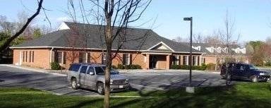
345 Westside Station Dr, Winchester, VA 22601

Property Detail
345 Westside Station Dr
168-01-5
WESTSIDE STATION SD S-3 L-5 345 WESTSIDE STATION DRIVE
Officebuilding
WINCHESTER
RO1
Virginia
B and X Area of moderate flood hazard, usually the area between the limits of the 100-year and 500-year floods.
5
2025
1.13 AC
2025
Winchester City
000202
Washington, DC
2,400 SF
Winchester, VA-WV
NEARBY LISTINGS FOR SALE OR LEASE
DEMOGRAPHICS near 345 Westside Station Dr
1 mile
3 mile
5 mile
2025 Total Population
2,262
32,638
62,378
2030 Population
2,286
32,653
63,841
Pop Growth 2025-2030
+ 1.06%
+ 0.05%
+ 2.35%
Average Age
47
41
41
2025 Total Households
917
13,282
23,956
HH Growth 2025-2030
+ 0.98%
(0.02%)
+ 2.18%
Median Household Inc
$110,326
$69,322
$73,866
Avg Household Size
2.40
2.30
2.50
2025 Avg HH Vehicles
2.00
2.00
2.00
Median Home Value
$494,680
$375,594
$364,830
Median Year Built
1981
1974
1983
Nearby Places
Map Layers
Map Styles
 Street
 Aerial
Layers
 Traffic
 Biking
Places
Listings with unknown addresses are not visible on the map
- Restaurants
- Banks
- Shops
- Fitness
- Groceries
SALE & LEASE HISTORY
LISTING DATE
SALE/LEASE

Jul 17, 2018
For Lease
Nearby Properties
Address
Land Use
TOTAL SIZE
Lot Size
Zoning
Address
Land Use
TOTAL SIZE
Lot Size
Zoning
979,509 SF
161.49 AC
MC
Address
Land Use
TOTAL SIZE
Lot Size
Zoning
90,399 SF
131.06 AC
MS
Address
Land Use
TOTAL SIZE
Lot Size
Zoning
31,710 SF
47.28 AC
HE1
Address
Land Use
TOTAL SIZE
Lot Size
Zoning
47,089 SF
16.84 AC
LR
Address
Land Use
TOTAL SIZE
Lot Size
Zoning
10,821 SF
68.86 AC
RA
Address
Land Use
TOTAL SIZE
Lot Size
Zoning
40,820 SF
31.78 AC
M1
Address
Land Use
TOTAL SIZE
Lot Size
Zoning
33,264 SF
10.59 AC
MR
Address
Land Use
TOTAL SIZE
Lot Size
Zoning
191,138 SF
35 AC
EIP
Address
Land Use
TOTAL SIZE
Lot Size
Zoning
11,979 SF
10.82 AC
HR
Address
Land Use
TOTAL SIZE
Lot Size
Zoning
462,500 SF
53.51 AC
B2
Address
Land Use
TOTAL SIZE
Lot Size
Zoning
423,360 SF
24.23 AC
M1
Address
Land Use
TOTAL SIZE
Lot Size
Zoning
27,464 SF
8.53 AC
B2
Address
Land Use
TOTAL SIZE
Lot Size
Zoning
231,756 SF
23.66 AC
CM1
Address
Land Use
TOTAL SIZE
Lot Size
Zoning
151,711 SF
16.25 AC
CM1
Address
Land Use
TOTAL SIZE
Lot Size
Zoning
181,832 SF
17.96 AC
CM1
Address
Land Use
TOTAL SIZE
Lot Size
Zoning
65,320 SF
2.62 AC
B1
Address
Land Use
TOTAL SIZE
Lot Size
Zoning
153,024 SF
33.47 AC
EIP
Address
Land Use
TOTAL SIZE
Lot Size
Zoning
64,711 SF
18.10 AC
B2
Address
Land Use
TOTAL SIZE
Lot Size
Zoning
56,746 SF
30 AC
M1
Address
Land Use
TOTAL SIZE
Lot Size
Zoning
5,293 SF
195.07 AC
LR
Address
Land Use
TOTAL SIZE
Lot Size
Zoning
96,721 SF
9.19 AC
EIP
Address
Land Use
TOTAL SIZE
Lot Size
Zoning
257,491 SF
24.40 AC
M1
Address
Land Use
TOTAL SIZE
Lot Size
Zoning
94,606 SF
4.92 AC
B2
Address
Land Use
TOTAL SIZE
Lot Size
Zoning
20,844 SF
11.58 AC
RP
Address
Land Use
TOTAL SIZE
Lot Size
Zoning
199,053 SF
20.53 AC
B2
Address
Land Use
TOTAL SIZE
Lot Size
Zoning
87,000 SF
16.30 AC
EIP
Address
Land Use
TOTAL SIZE
Lot Size
Zoning
151,000 SF
26.91 AC
LR
Address
Land Use
TOTAL SIZE
Lot Size
Zoning
83,786 SF
2.71 AC
HE1
Address
Land Use
TOTAL SIZE
Lot Size
Zoning
73,226 SF
10.24 AC
B2
Address
Land Use
TOTAL SIZE
Lot Size
Zoning
91,468 SF
7.37 AC
EIP
The World's #1 Commercial Real Estate Marketplace
Connect with us
© 2026 CoStar Group
The information above has been obtained from sources believed reliable. While we do not doubt its accuracy we have not verified it and make no guarantee, warranty or representation about it. It is your responsibility to independently confirm its accuracy and completeness. Any projections, opinions, assumptions, or estimates used are for example only and do not represent the current or future performance of the property. The value of this transaction to you depends on tax and other factors which should be evaluated by your tax, financial, and legal advisors. You and your advisors should conduct a careful, independent investigation of the property to determine to your satisfaction the suitability of the property for your needs.