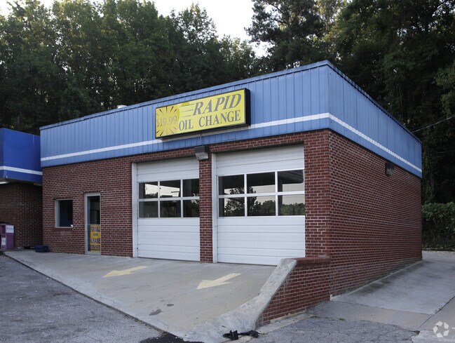
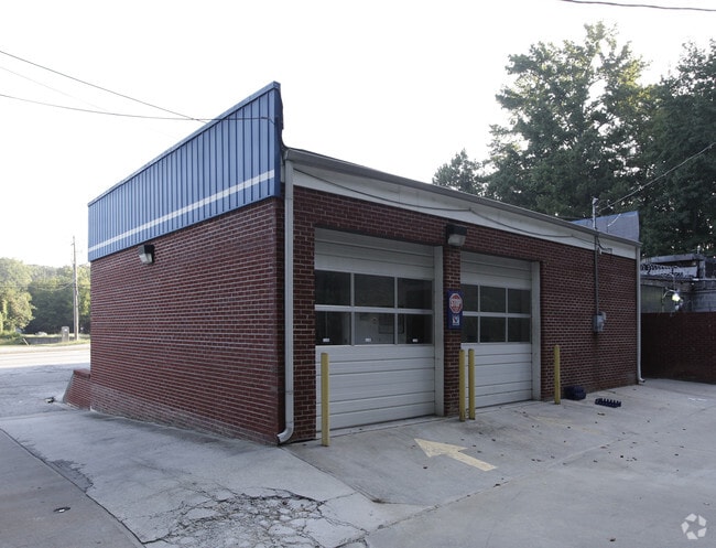
Property Record
3450 Cascade Rd Sw, Atlanta, GA 30311

NEARBY LISTINGS FOR SALE OR LEASE
Property Detail
3450 Cascade Rd Sw
Atlanta-Sandy Springs-Roswell, GA
Ethel L Jackson Prop
14-0248-0001-044-0
KA: EXXON CONVENIENCE STORE
Supermarket
Fulton
X
Georgia
13121C0332F
248
2024
0.70 AC
2025
College Park/SW Atl
007707
Atlanta
3,103 SF
DEMOGRAPHICS near 3450 Cascade Rd Sw
1 Mile
3 Mile
5 Mile
2024 Total Population
4,481
61,850
170,962
2029 Population
4,619
64,082
177,931
Pop Growth 2024-2029
+ 3.08%
+ 3.61%
+ 4.08%
Average Age
43
40
39
2024 Total Households
1,925
25,649
70,982
HH Growth 2024-2029
+ 3.17%
+ 3.73%
+ 4.10%
Median Household Inc
$61,918
$49,751
$48,789
Avg Household Size
2.30
2.40
2.30
2024 Avg HH Vehicles
2.00
1.00
1.00
Median Home Value
$268,599
$254,584
$246,581
Median Year Built
1968
1973
1969
Nearby Places
Map Layers
Map Styles
 Street
 Aerial
- Restaurants
- Banks
- Shops
- Fitness
- Groceries
PUBLIC TRANSPORTATION
AIRPORT
Hartsfield - Jackson Atlanta International
DRIVE
WALK
Distance
Hartsfield - Jackson Atlanta International
21 min
14.2 mi
Freight Ports
Georgia Ports - Savannah
DRIVE
WALK
Distance
Georgia Ports - Savannah
282 min
251.5 mi
SALE & LEASE HISTORY
LISTING DATE
SALE/LEASE

Apr 07, 2022
For Lease
Nearby Properties
Address
Land Use
TOTAL SIZE
Lot Size
Zoning
Address
Land Use
TOTAL SIZE
Lot Size
Zoning
802,908 SF
18.26 AC
RG3
Address
Land Use
TOTAL SIZE
Lot Size
Zoning
5,459 SF
12.97 AC
C1
Address
Land Use
TOTAL SIZE
Lot Size
Zoning
3,411,710 SF
25.97 AC
RG3
Address
Land Use
TOTAL SIZE
Lot Size
Zoning
282,610 SF
11.20 AC
C1
Address
Land Use
TOTAL SIZE
Lot Size
Zoning
6,603,740 SF
24.69 AC
RG3
Address
Land Use
TOTAL SIZE
Lot Size
Zoning
814,536 SF
37 AC
R3
Address
Land Use
TOTAL SIZE
Lot Size
Zoning
274,442 SF
20.33 AC
RG2
Address
Land Use
TOTAL SIZE
Lot Size
Zoning
3,268,352 SF
23.31 AC
RG2
Address
Land Use
TOTAL SIZE
Lot Size
Zoning
135,211 SF
51.76 AC
OI
Address
Land Use
TOTAL SIZE
Lot Size
Zoning
1,825,146 SF
16.16 AC
RG3
Address
Land Use
TOTAL SIZE
Lot Size
Zoning
3,289,702 SF
16.23 AC
C1C
Address
Land Use
TOTAL SIZE
Lot Size
Zoning
395,218 SF
21.61 AC
A1
Address
Land Use
TOTAL SIZE
Lot Size
Zoning
70.35 AC
R3
Address
Land Use
TOTAL SIZE
Lot Size
Zoning
6,834,480 SF
9.85 AC
RG3
Address
Land Use
TOTAL SIZE
Lot Size
Zoning
2,002,026 SF
17.51 AC
RLC
Address
Land Use
TOTAL SIZE
Lot Size
Zoning
9,590,784 SF
27.23 AC
RG3
Address
Land Use
TOTAL SIZE
Lot Size
Zoning
764,659 SF
51.57 AC
C1
Address
Land Use
TOTAL SIZE
Lot Size
Zoning
1,715,322 SF
18.09 AC
A1
Address
Land Use
TOTAL SIZE
Lot Size
Zoning
1,477,770 SF
13.60 AC
C1
Address
Land Use
TOTAL SIZE
Lot Size
Zoning
680,087 SF
41.40 AC
M2
Address
Land Use
TOTAL SIZE
Lot Size
Zoning
910 SF
28.75 AC
R1
Address
Land Use
TOTAL SIZE
Lot Size
Zoning
725,612 SF
11.60 AC
A
Address
Land Use
TOTAL SIZE
Lot Size
Zoning
7,668 SF
17.29 AC
C1
Address
Land Use
TOTAL SIZE
Lot Size
Zoning
874,924 SF
10 AC
C1
Address
Land Use
TOTAL SIZE
Lot Size
Zoning
130,000 SF
4.28 AC
R4
Address
Land Use
TOTAL SIZE
Lot Size
Zoning
191,540 SF
7.74 AC
RG3
Address
Land Use
TOTAL SIZE
Lot Size
Zoning
1,454,400 SF
14.81 AC
RG3
Address
Land Use
TOTAL SIZE
Lot Size
Zoning
442,740 SF
5.46 AC
RG3
Address
Land Use
TOTAL SIZE
Lot Size
Zoning
156,148 SF
27.07 AC
C1
Address
Land Use
TOTAL SIZE
Lot Size
Zoning
122.60 AC
R3
The World's #1 Commercial Real Estate Marketplace
Connect with us
© 2025 CoStar Group
The information above has been obtained from sources believed reliable. While we do not doubt its accuracy we have not verified it and make no guarantee, warranty or representation about it. It is your responsibility to independently confirm its accuracy and completeness. Any projections, opinions, assumptions, or estimates used are for example only and do not represent the current or future performance of the property. The value of this transaction to you depends on tax and other factors which should be evaluated by your tax, financial, and legal advisors. You and your advisors should conduct a careful, independent investigation of the property to determine to your satisfaction the suitability of the property for your needs.