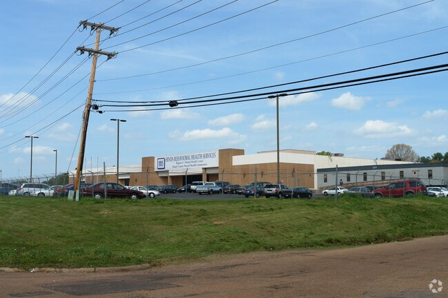
Property Record
3450 W Highway 80 W, Jackson, MS 39209

Property Detail
3450 W Highway 80 W
0648-0015-000
SW 1/4 SW 1/4 SEC 6 T5 R1E LESS 9.012 AC TO J S S D & LESS TO STATE HWY COMM & LESS TO MACCO PROPERTIES INC LESS TO HUGHES & BECKNELL CONST CO & LESS W/S TO 84 LUMBER CO
Charitableorganization
Hinds
B and X Area of moderate flood hazard, usually the area between the limits of the 100-year and 500-year floods.
Mississippi
0
4.79 AC
2025
South Jackson
002400
Jackson
62,857 SF
Jackson, MS
NEARBY LISTINGS FOR SALE OR LEASE
-
-
View all Jackson listings for sale on LoopNet.com
DEMOGRAPHICS near 3450 W Highway 80 W
1 mile
3 mile
5 mile
2025 Total Population
5,997
51,169
99,351
2030 Population
5,980
50,614
97,009
Pop Growth 2025-2030
(0.28%)
(1.08%)
(2.36%)
Average Age
37
37
38
2025 Total Households
2,541
20,215
40,983
HH Growth 2025-2030
(0.51%)
(1.13%)
(2.48%)
Median Household Inc
$34,654
$34,860
$38,523
Avg Household Size
2.20
2.30
2.30
2025 Avg HH Vehicles
2.00
2.00
2.00
Median Home Value
$77,592
$68,585
$82,461
Median Year Built
1968
1965
1968
Nearby Places
Map Layers
Map Styles
 Street
 Aerial
Layers
 Traffic
 Biking
Places
Listings with unknown addresses are not visible on the map
- Restaurants
- Banks
- Shops
- Fitness
- Groceries
PUBLIC TRANSPORTATION
COMMUTER RAIL
Jackson (City of New Orleans - Amtrak)
Drive
Walk
Distance
Jackson (City of New Orleans - Amtrak)
7 min
3.8 mi
AIRPORT
Jackson-Medgar Wiley Evers International
Drive
Walk
Distance
Jackson-Medgar Wiley Evers International
22 min
14.2 mi
Freight Ports
Port of Greater Baton Rouge
Drive
Walk
Distance
Port of Greater Baton Rouge
197 min
176.5 mi
Nearby Properties
Address
Land Use
TOTAL SIZE
Lot Size
Zoning
Address
Land Use
TOTAL SIZE
Lot Size
Zoning
113,434 SF
82.60 AC
Address
Land Use
TOTAL SIZE
Lot Size
Zoning
191,128 SF
29.57 AC
Address
Land Use
TOTAL SIZE
Lot Size
Zoning
145,789 SF
6 AC
Address
Land Use
TOTAL SIZE
Lot Size
Zoning
192,048 SF
23.70 AC
Address
Land Use
TOTAL SIZE
Lot Size
Zoning
10,100 SF
548 AC
Address
Land Use
TOTAL SIZE
Lot Size
Zoning
45,186 SF
0.15 AC
Address
Land Use
TOTAL SIZE
Lot Size
Zoning
545,127 SF
36 AC
Address
Land Use
TOTAL SIZE
Lot Size
Zoning
41,110 SF
4.48 AC
Address
Land Use
TOTAL SIZE
Lot Size
Zoning
72,000 SF
0.01 AC
Address
Land Use
TOTAL SIZE
Lot Size
Zoning
76,780 SF
4 AC
Address
Land Use
TOTAL SIZE
Lot Size
Zoning
Address
Land Use
TOTAL SIZE
Lot Size
Zoning
199,954 SF
23 AC
Address
Land Use
TOTAL SIZE
Lot Size
Zoning
108,878 SF
7.87 AC
Address
Land Use
TOTAL SIZE
Lot Size
Zoning
108,979 SF
5 AC
Address
Land Use
TOTAL SIZE
Lot Size
Zoning
22,109 SF
1 AC
Address
Land Use
TOTAL SIZE
Lot Size
Zoning
132,342 SF
4 AC
Address
Land Use
TOTAL SIZE
Lot Size
Zoning
36,159 SF
1 AC
Address
Land Use
TOTAL SIZE
Lot Size
Zoning
50,314 SF
115 AC
Address
Land Use
TOTAL SIZE
Lot Size
Zoning
Address
Land Use
TOTAL SIZE
Lot Size
Zoning
171,950 SF
9 AC
Address
Land Use
TOTAL SIZE
Lot Size
Zoning
138,086 SF
14 AC
Address
Land Use
TOTAL SIZE
Lot Size
Zoning
223,892 SF
15 AC
Address
Land Use
TOTAL SIZE
Lot Size
Zoning
16,070 SF
6 AC
Address
Land Use
TOTAL SIZE
Lot Size
Zoning
11,950 SF
2 AC
Address
Land Use
TOTAL SIZE
Lot Size
Zoning
242,035 SF
15.80 AC
Address
Land Use
TOTAL SIZE
Lot Size
Zoning
11,256 SF
3.60 AC
Address
Land Use
TOTAL SIZE
Lot Size
Zoning
16,665 SF
1 AC
Address
Land Use
TOTAL SIZE
Lot Size
Zoning
7.28 AC
Address
Land Use
TOTAL SIZE
Lot Size
Zoning
0.03 AC
The World's #1 Commercial Real Estate Marketplace
Connect with us
© 2026 CoStar Group
The information above has been obtained from sources believed reliable. While we do not doubt its accuracy we have not verified it and make no guarantee, warranty or representation about it. It is your responsibility to independently confirm its accuracy and completeness. Any projections, opinions, assumptions, or estimates used are for example only and do not represent the current or future performance of the property. The value of this transaction to you depends on tax and other factors which should be evaluated by your tax, financial, and legal advisors. You and your advisors should conduct a careful, independent investigation of the property to determine to your satisfaction the suitability of the property for your needs.