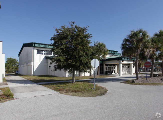
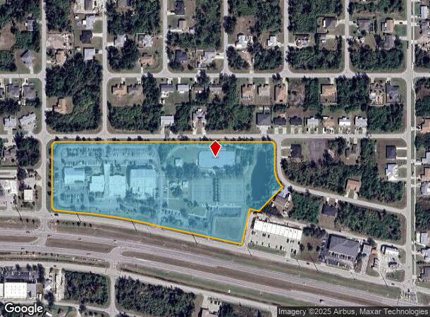
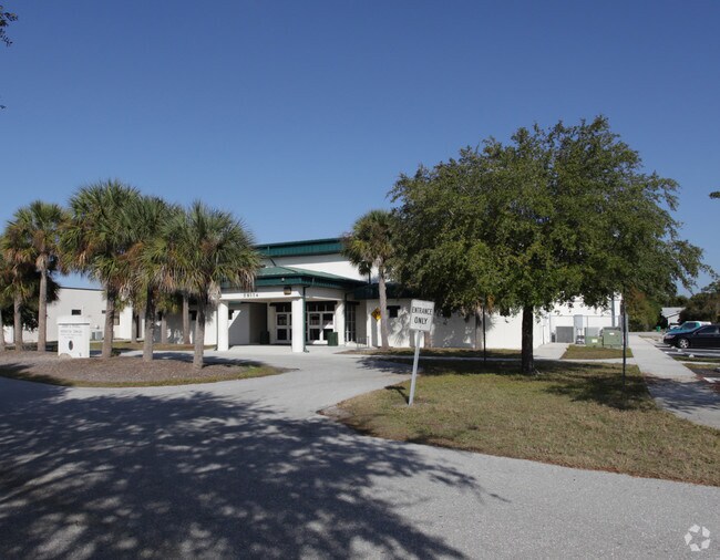
Property Record
3450 N Access Rd, Englewood, FL 34224
NEARBY LISTINGS FOR SALE OR LEASE
Property Detail
3450 N Access Rd
Punta Gorda, FL
Port Charlotte
412003433001
PORT CHARLOTTE SEC 84 TRACTS A & B 8.02 AC. M/L 661/991 EM-776/523 EM-RESOLUTION 84-66 E1002-912 E1051-975 E1052-904 RES96-570 1485/293 ODN1608/1954 E3673/2023 PCH 084 4828 0024 PORT CHARLOTTE SEC 84 BLK 4828 LT 24 596/1879 1509/69 CD1761/2150
Countyproperty
Charlotte
X
Florida
12015C0191G
661
0
10.17 AC
2025
Charlotte County
030202
Southwest Florida
37,401 SF
DEMOGRAPHICS near 3450 N Access Rd
1 Mile
3 Mile
5 Mile
2024 Total Population
4,353
27,007
55,875
2029 Population
5,190
32,569
67,573
Pop Growth 2024-2029
+ 19.23%
+ 20.59%
+ 20.94%
Average Age
53
57
57
2024 Total Households
2,026
13,067
27,584
HH Growth 2024-2029
+ 19.45%
+ 20.88%
+ 21.13%
Median Household Inc
$51,130
$54,345
$57,595
Avg Household Size
2.10
2.00
2.00
2024 Avg HH Vehicles
2.00
2.00
2.00
Median Home Value
$224,171
$247,057
$270,281
Median Year Built
1989
1990
1989
Nearby Places
Map Layers
Map Styles
 Street
 Aerial
- Restaurants
- Banks
- Shops
- Fitness
- Groceries
PUBLIC TRANSPORTATION
AIRPORT
Punta Gorda
DRIVE
WALK
Distance
Punta Gorda
42 min
25.0 mi
Freight Ports
Port Manatee
DRIVE
WALK
Distance
Port Manatee
79 min
58.3 mi
Nearby Properties
Address
Land Use
TOTAL SIZE
Lot Size
Zoning
Address
Land Use
TOTAL SIZE
Lot Size
Zoning
796,848 SF
44.28 AC
RE1
Address
Land Use
TOTAL SIZE
Lot Size
Zoning
95,649 SF
10.41 AC
OPI
Address
Land Use
TOTAL SIZE
Lot Size
Zoning
193,100 SF
26.30 AC
PD
Address
Land Use
TOTAL SIZE
Lot Size
Zoning
28,490 SF
172 AC
PKR
Address
Land Use
TOTAL SIZE
Lot Size
Zoning
33,654 SF
10.19 AC
RMF5
Address
Land Use
TOTAL SIZE
Lot Size
Zoning
91,934 SF
8.39 AC
PD
Address
Land Use
TOTAL SIZE
Lot Size
Zoning
107,736 SF
35.90 AC
RMF5
Address
Land Use
TOTAL SIZE
Lot Size
Zoning
111,505 SF
9.53 AC
CG
Address
Land Use
TOTAL SIZE
Lot Size
Zoning
70,165 SF
22.18 AC
CG
Address
Land Use
TOTAL SIZE
Lot Size
Zoning
27.65 AC
RMF15
Address
Land Use
TOTAL SIZE
Lot Size
Zoning
58,185 SF
3.40 AC
IG
Address
Land Use
TOTAL SIZE
Lot Size
Zoning
89,501 SF
6.52 AC
CG
Address
Land Use
TOTAL SIZE
Lot Size
Zoning
25,777 SF
12.18 AC
PD
Address
Land Use
TOTAL SIZE
Lot Size
Zoning
55,760 SF
3.18 AC
CG
Address
Land Use
TOTAL SIZE
Lot Size
Zoning
25,478 SF
11.06 AC
IG
Address
Land Use
TOTAL SIZE
Lot Size
Zoning
42,228 SF
9.24 AC
RE1
Address
Land Use
TOTAL SIZE
Lot Size
Zoning
51,683 SF
7.16 AC
CG
Address
Land Use
TOTAL SIZE
Lot Size
Zoning
106,737 SF
20.80 AC
RMF5
Address
Land Use
TOTAL SIZE
Lot Size
Zoning
1,459 SF
11.21 AC
RSF4
Address
Land Use
TOTAL SIZE
Lot Size
Zoning
35,351 SF
7.44 AC
CG
Address
Land Use
TOTAL SIZE
Lot Size
Zoning
25,568 SF
2.73 AC
CG
Address
Land Use
TOTAL SIZE
Lot Size
Zoning
24,708 SF
14.89 AC
CT
Address
Land Use
TOTAL SIZE
Lot Size
Zoning
11.89 AC
RSF4
Address
Land Use
TOTAL SIZE
Lot Size
Zoning
14,200 SF
2.26 AC
IG
Address
Land Use
TOTAL SIZE
Lot Size
Zoning
38,632 SF
33.98 AC
OUE
Address
Land Use
TOTAL SIZE
Lot Size
Zoning
38.60 AC
PD
Address
Land Use
TOTAL SIZE
Lot Size
Zoning
26,248 SF
6.32 AC
PD
Address
Land Use
TOTAL SIZE
Lot Size
Zoning
11,509 SF
12.06 AC
RSF3.5
Address
Land Use
TOTAL SIZE
Lot Size
Zoning
25,130 SF
21.98 AC
RE1
The World's #1 Commercial Real Estate Marketplace
Connect with us
© 2025 CoStar Group
The information above has been obtained from sources believed reliable. While we do not doubt its accuracy we have not verified it and make no guarantee, warranty or representation about it. It is your responsibility to independently confirm its accuracy and completeness. Any projections, opinions, assumptions, or estimates used are for example only and do not represent the current or future performance of the property. The value of this transaction to you depends on tax and other factors which should be evaluated by your tax, financial, and legal advisors. You and your advisors should conduct a careful, independent investigation of the property to determine to your satisfaction the suitability of the property for your needs.