Property Record
3450 Parris Bridge Rd, Boiling Springs, SC 29316

Current Lease Availabilities
NEARBY LISTINGS FOR SALE OR LEASE
Property Detail
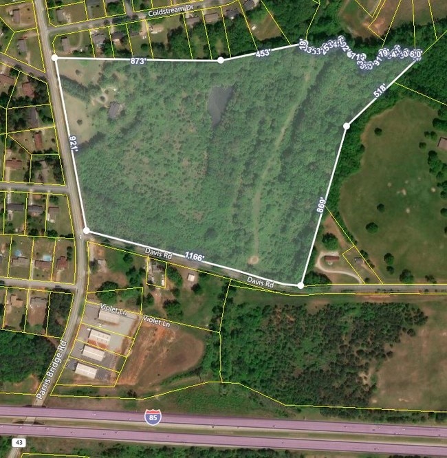
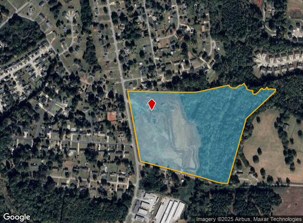
3450 Parris Bridge Rd
Spartanburg, SC
J R Burnett Est
2-52-00-004.00
LOT 9 J R BURNETT EST PB 47-408 DB 71G-257-261 DB 106G-316 DB 106G-307 DB 106G-309
Farms
Spartanburg
AE
South Carolina
45083C0164D
9
2024
38 AC
2025
North Side/Rt 9 Corridor
021402
Greenville/Spartanburg
2,104 SF
DEMOGRAPHICS near 3450 Parris Bridge Rd
1 Mile
3 Mile
5 Mile
2024 Total Population
4,113
31,946
83,432
2029 Population
4,611
36,165
94,632
Pop Growth 2024-2029
+ 12.11%
+ 13.21%
+ 13.42%
Average Age
38
37
37
2024 Total Households
1,555
12,163
31,450
HH Growth 2024-2029
+ 12.35%
+ 13.64%
+ 13.99%
Median Household Inc
$65,392
$55,391
$52,742
Avg Household Size
2.60
2.40
2.40
2024 Avg HH Vehicles
2.00
2.00
2.00
Median Home Value
$170,138
$170,517
$170,217
Median Year Built
1991
1993
1988
Nearby Places
- Restaurants
- Banks
- Shops
- Fitness
- Groceries
PUBLIC TRANSPORTATION
COMMUTER RAIL
Spartanburg Amtrak Station (Crescent - Amtrak)
DRIVE
WALK
Distance
Spartanburg Amtrak Station (Crescent - Amtrak)
11 min
4.8 mi
AIRPORT
Greenville Spartanburg International
DRIVE
WALK
Distance
Greenville Spartanburg International
30 min
20.8 mi
Freight Ports
North Charleston Terminal
DRIVE
WALK
Distance
North Charleston Terminal
226 min
201.3 mi
Nearby Properties
Address
Land Use
TOTAL SIZE
Lot Size
Zoning
Address
Land Use
TOTAL SIZE
Lot Size
Zoning
5,672 SF
10.20 AC
Address
Land Use
TOTAL SIZE
Lot Size
Zoning
27,491 SF
2.95 AC
Address
Land Use
TOTAL SIZE
Lot Size
Zoning
5,547 SF
6.58 AC
Address
Land Use
TOTAL SIZE
Lot Size
Zoning
141,112 SF
3.38 AC
Address
Land Use
TOTAL SIZE
Lot Size
Zoning
22,955 SF
5.05 AC
Address
Land Use
TOTAL SIZE
Lot Size
Zoning
19,876 SF
0.03 AC
Address
Land Use
TOTAL SIZE
Lot Size
Zoning
12,740 SF
1.48 AC
Address
Land Use
TOTAL SIZE
Lot Size
Zoning
13,160 SF
1.62 AC
Address
Land Use
TOTAL SIZE
Lot Size
Zoning
12,069 SF
0.03 AC
Address
Land Use
TOTAL SIZE
Lot Size
Zoning
44,301 SF
7.47 AC
Address
Land Use
TOTAL SIZE
Lot Size
Zoning
3,412 SF
21.60 AC
Address
Land Use
TOTAL SIZE
Lot Size
Zoning
122,626 SF
7.70 AC
Address
Land Use
TOTAL SIZE
Lot Size
Zoning
8,872 SF
0.03 AC
Address
Land Use
TOTAL SIZE
Lot Size
Zoning
5,034 SF
17.60 AC
Address
Land Use
TOTAL SIZE
Lot Size
Zoning
6,798 SF
31.44 AC
Address
Land Use
TOTAL SIZE
Lot Size
Zoning
83,698 SF
18.14 AC
Address
Land Use
TOTAL SIZE
Lot Size
Zoning
81,040 SF
15.39 AC
Address
Land Use
TOTAL SIZE
Lot Size
Zoning
89,435 SF
5.33 AC
Address
Land Use
TOTAL SIZE
Lot Size
Zoning
20,976 SF
23.72 AC
Address
Land Use
TOTAL SIZE
Lot Size
Zoning
2,328 SF
16.99 AC
Address
Land Use
TOTAL SIZE
Lot Size
Zoning
3,112 SF
20.17 AC
Address
Land Use
TOTAL SIZE
Lot Size
Zoning
8,911 SF
23.64 AC
Address
Land Use
TOTAL SIZE
Lot Size
Zoning
6,816 SF
14.16 AC
Address
Land Use
TOTAL SIZE
Lot Size
Zoning
9,649 SF
9.67 AC
Address
Land Use
TOTAL SIZE
Lot Size
Zoning
5,693 SF
0.03 AC
Address
Land Use
TOTAL SIZE
Lot Size
Zoning
64,471 SF
18.66 AC
Address
Land Use
TOTAL SIZE
Lot Size
Zoning
2,220 SF
14.09 AC
Address
Land Use
TOTAL SIZE
Lot Size
Zoning
76,325 SF
17.28 AC
Address
Land Use
TOTAL SIZE
Lot Size
Zoning
6,454 SF
0.70 AC
Address
Land Use
TOTAL SIZE
Lot Size
Zoning
52,714 SF
4.81 AC
The World's #1 Commercial Real Estate Marketplace
Connect with us
© 2025 CoStar Group
The information above has been obtained from sources believed reliable. While we do not doubt its accuracy we have not verified it and make no guarantee, warranty or representation about it. It is your responsibility to independently confirm its accuracy and completeness. Any projections, opinions, assumptions, or estimates used are for example only and do not represent the current or future performance of the property. The value of this transaction to you depends on tax and other factors which should be evaluated by your tax, financial, and legal advisors. You and your advisors should conduct a careful, independent investigation of the property to determine to your satisfaction the suitability of the property for your needs.