Property Record
3451 Queens St, Sarasota, FL 34231
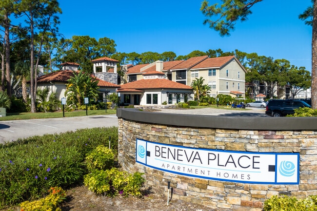

Property Detail
3451 Queens St
0101-08-0001
COM AT SW COR OF NE 1/4 OF NE 1/4 OF SEC 16-37-18 TH N-0-09-W 25 FT FOR POB TH CONT N-0-09-W 676.59 FT TH N-89-56-E 586.15 FT TH S-13-14-58-E 588.85 FT TH SELY ALG CURVE TO LEFT 116.36 FT TH
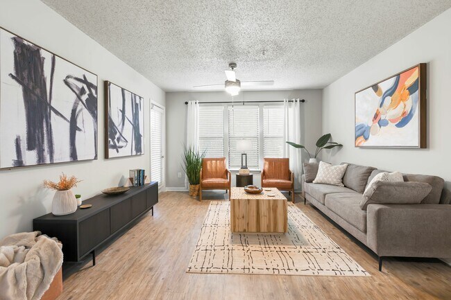
Multifamilydwelling
Sarasota
RMF4
Florida
AE The base floodplain where base flood elevations are provided. AE Zones are now used on new format FIRMs instead of A1-A30 Zones.
10.55 AC
2024
South Sarasota
2025
Tampa/St Petersburg
002003
North Port-Bradenton-Sarasota, FL
150,433 SF
NEARBY LISTINGS FOR SALE OR LEASE
DEMOGRAPHICS near 3451 Queens St
1 mile
3 mile
5 mile
2025 Total Population
10,694
74,625
150,356
2030 Population
11,283
79,817
160,827
Pop Growth 2025-2030
+ 5.51%
+ 6.96%
+ 6.96%
Average Age
49
51
50
2025 Total Households
5,073
35,510
69,735
HH Growth 2025-2030
+ 5.34%
+ 7.10%
+ 7.14%
Median Household Inc
$65,474
$79,848
$83,047
Avg Household Size
2.00
2.00
2.10
2025 Avg HH Vehicles
2.00
2.00
2.00
Median Home Value
$399,820
$492,609
$504,037
Median Year Built
1979
1981
1982
Nearby Places
Map Layers
Map Styles
 Street
 Aerial
Layers
 Traffic
 Biking
Places
Listings with unknown addresses are not visible on the map
- Restaurants
- Banks
- Shops
- Fitness
- Groceries
PUBLIC TRANSPORTATION
AIRPORT
Sarasota/Bradenton International
Drive
Walk
Distance
Sarasota/Bradenton International
24 min
12.4 mi
Freight Ports
Port Manatee
Drive
Walk
Distance
Port Manatee
44 min
32.3 mi
Nearby Properties
Address
Land Use
TOTAL SIZE
Lot Size
Zoning
Address
Land Use
TOTAL SIZE
Lot Size
Zoning
912,672 SF
88.39 AC
RMF1
Address
Land Use
TOTAL SIZE
Lot Size
Zoning
588,839 SF
42.33 AC
GU
Address
Land Use
TOTAL SIZE
Lot Size
Zoning
530,029 SF
14.92 AC
RMF4
Address
Land Use
TOTAL SIZE
Lot Size
Zoning
19,761 SF
119.20 AC
RMH
Address
Land Use
TOTAL SIZE
Lot Size
Zoning
912,253 SF
43.46 AC
PID
Address
Land Use
TOTAL SIZE
Lot Size
Zoning
432,668 SF
72.05 AC
GU
Address
Land Use
TOTAL SIZE
Lot Size
Zoning
318,414 SF
22.35 AC
RMF1
Address
Land Use
TOTAL SIZE
Lot Size
Zoning
258,994 SF
20.03 AC
PCD
Address
Land Use
TOTAL SIZE
Lot Size
Zoning
263,961 SF
18.88 AC
RMF3
Address
Land Use
TOTAL SIZE
Lot Size
Zoning
312,294 SF
40.21 AC
OPI
Address
Land Use
TOTAL SIZE
Lot Size
Zoning
286,775 SF
10.85 AC
RMF3
Address
Land Use
TOTAL SIZE
Lot Size
Zoning
181,467 SF
59.39 AC
RMF1
Address
Land Use
TOTAL SIZE
Lot Size
Zoning
332,822 SF
34.74 AC
CG
Address
Land Use
TOTAL SIZE
Lot Size
Zoning
157,854 SF
8.32 AC
OPI
Address
Land Use
TOTAL SIZE
Lot Size
Zoning
223,929 SF
28.24 AC
RMF1
Address
Land Use
TOTAL SIZE
Lot Size
Zoning
17,785 SF
56.32 AC
RMF2
Address
Land Use
TOTAL SIZE
Lot Size
Zoning
87,816 SF
24.83 AC
ILW
Address
Land Use
TOTAL SIZE
Lot Size
Zoning
148,339 SF
12.86 AC
CG
Address
Land Use
TOTAL SIZE
Lot Size
Zoning
373,288 SF
53.07 AC
PID
Address
Land Use
TOTAL SIZE
Lot Size
Zoning
233,075 SF
19.49 AC
RMF2
Address
Land Use
TOTAL SIZE
Lot Size
Zoning
80,038 SF
28.10 AC
ILW
Address
Land Use
TOTAL SIZE
Lot Size
Zoning
133,430 SF
19.60 AC
GU
Address
Land Use
TOTAL SIZE
Lot Size
Zoning
146,339 SF
12.54 AC
CG
Address
Land Use
TOTAL SIZE
Lot Size
Zoning
89,418 SF
7.86 AC
GU
Address
Land Use
TOTAL SIZE
Lot Size
Zoning
205,136 SF
17.32 AC
RMF2
Address
Land Use
TOTAL SIZE
Lot Size
Zoning
177,957 SF
19.36 AC
G
Address
Land Use
TOTAL SIZE
Lot Size
Zoning
166,310 SF
40.38 AC
GU
Address
Land Use
TOTAL SIZE
Lot Size
Zoning
140,372 SF
14.31 AC
CG
Address
Land Use
TOTAL SIZE
Lot Size
Zoning
56,885 SF
10.14 AC
ILW
The World's #1 Commercial Real Estate Marketplace
Connect with us
© 2026 CoStar Group
The information above has been obtained from sources believed reliable. While we do not doubt its accuracy we have not verified it and make no guarantee, warranty or representation about it. It is your responsibility to independently confirm its accuracy and completeness. Any projections, opinions, assumptions, or estimates used are for example only and do not represent the current or future performance of the property. The value of this transaction to you depends on tax and other factors which should be evaluated by your tax, financial, and legal advisors. You and your advisors should conduct a careful, independent investigation of the property to determine to your satisfaction the suitability of the property for your needs.