Property Record
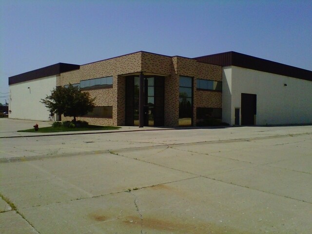
34519 Bennett, Fraser, MI 48026

Property Detail
34519 Bennett
03-11-32-206-007
2007 SPLIT FROM 11-32-206-002 BENNETT INDUSTRIAL COMPLEX (L 91, P 32-33) PART OF LOT 1 DESC AS THAT PART LYING NWLY OF A LINE
Lightindustrial
Macomb
IR
Michigan
B and X Area of moderate flood hazard, usually the area between the limits of the 100-year and 500-year floods.
1
2025
1.34 AC
2025
Groesbeck Central
254000
Detroit
24,776 SF
Detroit-Warren-Dearborn, MI
NEARBY LISTINGS FOR SALE OR LEASE
DEMOGRAPHICS near 34519 Bennett
1 mile
3 mile
5 mile
2025 Total Population
11,127
108,151
305,877
2030 Population
11,296
109,667
308,871
Pop Growth 2025-2030
+ 1.52%
+ 1.40%
+ 0.98%
Average Age
43
43
43
2025 Total Households
4,951
46,251
131,021
HH Growth 2025-2030
+ 1.47%
+ 1.57%
+ 1.13%
Median Household Inc
$66,023
$66,555
$69,585
Avg Household Size
2.20
2.30
2.30
2025 Avg HH Vehicles
2.00
2.00
2.00
Median Home Value
$190,256
$201,194
$213,675
Median Year Built
1969
1971
1970
Nearby Places
Map Layers
Map Styles
 Street
 Aerial
Transit
 Traffic
 Biking
Places
Listings with unknown addresses are not visible on the map
- Restaurants
- Banks
- Shops
- Fitness
- Groceries
PUBLIC TRANSPORTATION
AIRPORT
Windsor International
Drive
Walk
Distance
Windsor International
57 min
33.9 mi
Detroit Metro Wayne County
Drive
Walk
Distance
Detroit Metro Wayne County
60 min
40.6 mi
SALE & LEASE HISTORY
LISTING DATE
SALE/LEASE

Jun 30, 2021
For Lease
Nearby Properties
Address
Land Use
TOTAL SIZE
Lot Size
Zoning
Address
Land Use
TOTAL SIZE
Lot Size
Zoning
436,218 SF
36.43 AC
B-2
Address
Land Use
TOTAL SIZE
Lot Size
Zoning
148,330 SF
37.86 AC
RM-2
Address
Land Use
TOTAL SIZE
Lot Size
Zoning
24.38 AC
RML
Address
Land Use
TOTAL SIZE
Lot Size
Zoning
82,475 SF
16.81 AC
RM-2
Address
Land Use
TOTAL SIZE
Lot Size
Zoning
249,162 SF
27.87 AC
IC
Address
Land Use
TOTAL SIZE
Lot Size
Zoning
10,070 SF
31.84 AC
RH
Address
Land Use
TOTAL SIZE
Lot Size
Zoning
236,221 SF
31.30 AC
B-2
Address
Land Use
TOTAL SIZE
Lot Size
Zoning
91,386 SF
B-2
Address
Land Use
TOTAL SIZE
Lot Size
Zoning
209,501 SF
17.74 AC
B-3
Address
Land Use
TOTAL SIZE
Lot Size
Zoning
91,104 SF
11.99 AC
RM-2
Address
Land Use
TOTAL SIZE
Lot Size
Zoning
247,177 SF
26.94 AC
CG
Address
Land Use
TOTAL SIZE
Lot Size
Zoning
217,369 SF
20.15 AC
B-2
Address
Land Use
TOTAL SIZE
Lot Size
Zoning
14.67 AC
RM-2
Address
Land Use
TOTAL SIZE
Lot Size
Zoning
57,316 SF
26.07 AC
RML
Address
Land Use
TOTAL SIZE
Lot Size
Zoning
218,819 SF
15 AC
R-3
Address
Land Use
TOTAL SIZE
Lot Size
Zoning
376,278 SF
19.85 AC
RM-1
Address
Land Use
TOTAL SIZE
Lot Size
Zoning
7.18 AC
RMH
Address
Land Use
TOTAL SIZE
Lot Size
Zoning
370,077 SF
18.24 AC
B-2
Address
Land Use
TOTAL SIZE
Lot Size
Zoning
10.37 AC
RML
Address
Land Use
TOTAL SIZE
Lot Size
Zoning
117,664 SF
6.66 AC
I-1
Address
Land Use
TOTAL SIZE
Lot Size
Zoning
157,610 SF
5.30 AC
RMH
Address
Land Use
TOTAL SIZE
Lot Size
Zoning
88.65 AC
MH
Address
Land Use
TOTAL SIZE
Lot Size
Zoning
108,366 SF
16.66 AC
O-2
Address
Land Use
TOTAL SIZE
Lot Size
Zoning
256 SF
5.57 AC
SP-1
Address
Land Use
TOTAL SIZE
Lot Size
Zoning
10.89 AC
RML
Address
Land Use
TOTAL SIZE
Lot Size
Zoning
41,065 SF
4.30 AC
B-3
Address
Land Use
TOTAL SIZE
Lot Size
Zoning
131,812 SF
12.56 AC
B-3
Address
Land Use
TOTAL SIZE
Lot Size
Zoning
7.20 AC
RM-2
Address
Land Use
TOTAL SIZE
Lot Size
Zoning
187,320 SF
9.55 AC
CG
Address
Land Use
TOTAL SIZE
Lot Size
Zoning
73,658 SF
14.94 AC
B-3
The World's #1 Commercial Real Estate Marketplace
Connect with us
© 2026 CoStar Group
The information above has been obtained from sources believed reliable. While we do not doubt its accuracy we have not verified it and make no guarantee, warranty or representation about it. It is your responsibility to independently confirm its accuracy and completeness. Any projections, opinions, assumptions, or estimates used are for example only and do not represent the current or future performance of the property. The value of this transaction to you depends on tax and other factors which should be evaluated by your tax, financial, and legal advisors. You and your advisors should conduct a careful, independent investigation of the property to determine to your satisfaction the suitability of the property for your needs.