Property Record
3455 Highway 81 E, Mcdonough, GA 30252
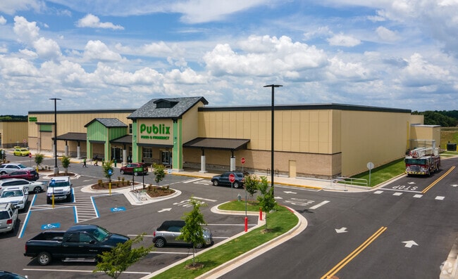

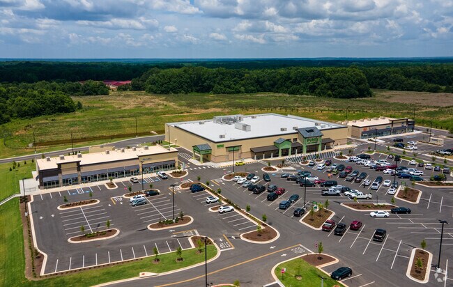
Property Detail
3455 Highway 81 E
0155-01-001-010
PER LWD 17666/146 SPLIT 1.134 AC FROM 155-1-1.010 TO CREATE 155-1-1.011 PER LWD 16876/154 -SPLIT 14.
Regionalshoppingcenterormallwithanchorstore
HENRY
B and X Area of moderate flood hazard, usually the area between the limits of the 100-year and 500-year floods.
Georgia
2025
11.53 AC
2025
McDonough/Butts
070209
Atlanta
28,620 SF
Atlanta-Sandy Springs-Roswell, GA
NEARBY LISTINGS FOR SALE OR LEASE
-
-
View all Mcdonough listings for sale on LoopNet.com
DEMOGRAPHICS near 3455 Highway 81 E
1 mile
3 mile
5 mile
2025 Total Population
766
17,819
40,611
2030 Population
817
18,959
43,407
Pop Growth 2025-2030
+ 6.66%
+ 6.40%
+ 6.88%
Average Age
39
39
38
2025 Total Households
244
5,750
13,145
HH Growth 2025-2030
+ 6.56%
+ 6.52%
+ 7.02%
Median Household Inc
$98,935
$93,251
$98,396
Avg Household Size
3.10
3.10
3.10
2025 Avg HH Vehicles
3.00
3.00
3.00
Median Home Value
$382,177
$360,847
$365,182
Median Year Built
2006
2001
2002
Nearby Places
Map Layers
Map Styles
 Street
 Aerial
Layers
 Traffic
 Biking
Places
Listings with unknown addresses are not visible on the map
- Restaurants
- Banks
- Shops
- Fitness
- Groceries
PUBLIC TRANSPORTATION
AIRPORT
Hartsfield - Jackson Atlanta International
Drive
Walk
Distance
Hartsfield - Jackson Atlanta International
45 min
32.8 mi
Nearby Properties
Address
Land Use
TOTAL SIZE
Lot Size
Zoning
Address
Land Use
TOTAL SIZE
Lot Size
Zoning
123,864 SF
94.78 AC
Address
Land Use
TOTAL SIZE
Lot Size
Zoning
137,972 SF
26.34 AC
RA
Address
Land Use
TOTAL SIZE
Lot Size
Zoning
88,006 SF
51 AC
Address
Land Use
TOTAL SIZE
Lot Size
Zoning
58,494 SF
15.11 AC
C1
Address
Land Use
TOTAL SIZE
Lot Size
Zoning
2,478 SF
75.30 AC
R2
Address
Land Use
TOTAL SIZE
Lot Size
Zoning
263,412 SF
10.01 AC
RA
Address
Land Use
TOTAL SIZE
Lot Size
Zoning
20,022 SF
4.46 AC
C1
Address
Land Use
TOTAL SIZE
Lot Size
Zoning
3,493 SF
1.04 AC
Address
Land Use
TOTAL SIZE
Lot Size
Zoning
32,851 SF
5.73 AC
RA
Address
Land Use
TOTAL SIZE
Lot Size
Zoning
2,676 SF
1.13 AC
Address
Land Use
TOTAL SIZE
Lot Size
Zoning
17,240 SF
1.06 AC
Address
Land Use
TOTAL SIZE
Lot Size
Zoning
13,483 SF
4.66 AC
C2
Address
Land Use
TOTAL SIZE
Lot Size
Zoning
1,864 SF
171.16 AC
RA
Address
Land Use
TOTAL SIZE
Lot Size
Zoning
105 AC
RA
Address
Land Use
TOTAL SIZE
Lot Size
Zoning
2,997 SF
2.69 AC
C2
Address
Land Use
TOTAL SIZE
Lot Size
Zoning
1,804 SF
120.03 AC
RA
Address
Land Use
TOTAL SIZE
Lot Size
Zoning
5,326 SF
3.25 AC
OI
Address
Land Use
TOTAL SIZE
Lot Size
Zoning
35,093 SF
25 AC
RA
Address
Land Use
TOTAL SIZE
Lot Size
Zoning
5,985 SF
1.71 AC
C1
Address
Land Use
TOTAL SIZE
Lot Size
Zoning
3,487 SF
1.89 AC
C2
Address
Land Use
TOTAL SIZE
Lot Size
Zoning
9,217 SF
1.50 AC
Address
Land Use
TOTAL SIZE
Lot Size
Zoning
4,406 SF
18.30 AC
RA
Address
Land Use
TOTAL SIZE
Lot Size
Zoning
10,409 SF
34.47 AC
RA
Address
Land Use
TOTAL SIZE
Lot Size
Zoning
8,080 SF
7.41 AC
RA
Address
Land Use
TOTAL SIZE
Lot Size
Zoning
5,964 SF
1.96 AC
C2
Address
Land Use
TOTAL SIZE
Lot Size
Zoning
4,984 SF
0.12 AC
Address
Land Use
TOTAL SIZE
Lot Size
Zoning
2,140 SF
38.99 AC
RA
Address
Land Use
TOTAL SIZE
Lot Size
Zoning
4,621 SF
17.16 AC
RA
The World's #1 Commercial Real Estate Marketplace
Connect with us
© 2026 CoStar Group
The information above has been obtained from sources believed reliable. While we do not doubt its accuracy we have not verified it and make no guarantee, warranty or representation about it. It is your responsibility to independently confirm its accuracy and completeness. Any projections, opinions, assumptions, or estimates used are for example only and do not represent the current or future performance of the property. The value of this transaction to you depends on tax and other factors which should be evaluated by your tax, financial, and legal advisors. You and your advisors should conduct a careful, independent investigation of the property to determine to your satisfaction the suitability of the property for your needs.