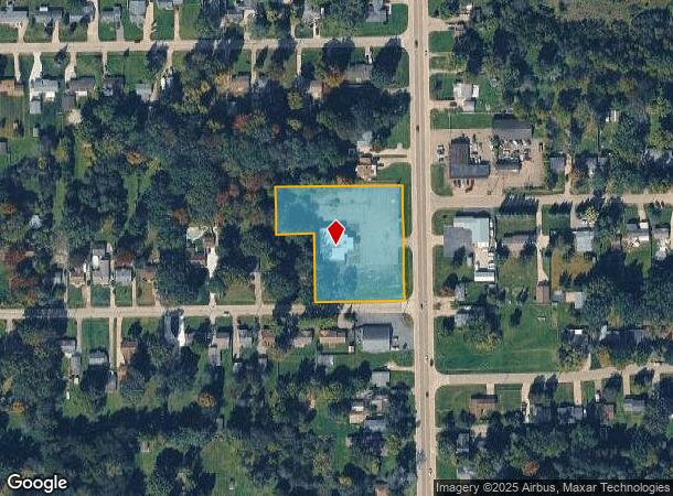
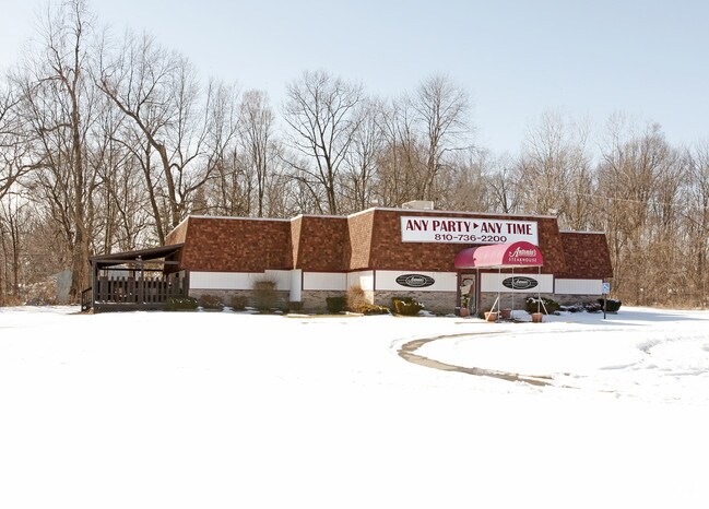
Property Record
3457 N Genesee Rd, Flint, MI 48506

NEARBY LISTINGS FOR SALE OR LEASE
Property Detail
3457 N Genesee Rd
Flint, MI
Kearsley Creek Sub
11-34-526-120
E 230 FT OF LOTS 116 117 & 118 & LOTS 119 & 120 KEARSLEY CREEK SUB NO 1 (82) FR 1100146061
Commercialnec
Genesee
X
Michigan
26049C0211D
116-120
2024
1.86 AC
2025
Flint
012006
Detroit
6,040 SF
DEMOGRAPHICS near 3457 N Genesee Rd
1 Mile
3 Mile
5 Mile
2024 Total Population
3,391
30,644
93,717
2029 Population
3,276
30,436
94,410
Pop Growth 2024-2029
(3.39%)
(0.68%)
+ 0.74%
Average Age
44
40
40
2024 Total Households
1,433
12,217
39,230
HH Growth 2024-2029
(3.35%)
(0.86%)
+ 0.68%
Median Household Inc
$56,244
$44,641
$40,706
Avg Household Size
2.30
2.40
2.30
2024 Avg HH Vehicles
2.00
2.00
1.00
Median Home Value
$138,555
$115,543
$97,154
Median Year Built
1959
1961
1963
Nearby Places
Map Layers
Map Styles
 Street
 Aerial
- Restaurants
- Banks
- Shops
- Fitness
- Groceries
PUBLIC TRANSPORTATION
COMMUTER RAIL
DRIVE
WALK
Distance
11 min
5.4 mi
AIRPORT
Bishop International
DRIVE
WALK
Distance
Bishop International
29 min
15.0 mi
Nearby Properties
Address
Land Use
TOTAL SIZE
Lot Size
Zoning
Address
Land Use
TOTAL SIZE
Lot Size
Zoning
MOBILE
Address
Land Use
TOTAL SIZE
Lot Size
Zoning
290,267 SF
79 AC
PC
Address
Land Use
TOTAL SIZE
Lot Size
Zoning
227,669 SF
25.87 AC
C-2
Address
Land Use
TOTAL SIZE
Lot Size
Zoning
371,636 SF
12.50 AC
M-1
Address
Land Use
TOTAL SIZE
Lot Size
Zoning
2,400 SF
81 AC
R-4 MANUF
Address
Land Use
TOTAL SIZE
Lot Size
Zoning
111,882 SF
5.36 AC
C-4
Address
Land Use
TOTAL SIZE
Lot Size
Zoning
419,038 SF
57.18 AC
M-2
Address
Land Use
TOTAL SIZE
Lot Size
Zoning
633 SF
69.20 AC
R-4 MANUF
Address
Land Use
TOTAL SIZE
Lot Size
Zoning
114,888 SF
11.86 AC
I-2 HVY IN
Address
Land Use
TOTAL SIZE
Lot Size
Zoning
Address
Land Use
TOTAL SIZE
Lot Size
Zoning
107,580 SF
5.18 AC
RETAIL
Address
Land Use
TOTAL SIZE
Lot Size
Zoning
2,874 SF
71.02 AC
R-4 MANUF
Address
Land Use
TOTAL SIZE
Lot Size
Zoning
192,900 SF
6.50 AC
CE
Address
Land Use
TOTAL SIZE
Lot Size
Zoning
118,210 SF
6.60 AC
CE
Address
Land Use
TOTAL SIZE
Lot Size
Zoning
72,720 SF
6.41 AC
C-2
Address
Land Use
TOTAL SIZE
Lot Size
Zoning
57.47 AC
R-4 MANUF
Address
Land Use
TOTAL SIZE
Lot Size
Zoning
726 SF
10.40 AC
R-4 MANUF
Address
Land Use
TOTAL SIZE
Lot Size
Zoning
2,560 SF
42 AC
R-4 MANUF
Address
Land Use
TOTAL SIZE
Lot Size
Zoning
58,197 SF
11.90 AC
C-2
Address
Land Use
TOTAL SIZE
Lot Size
Zoning
43,751 SF
3.14 AC
TN-2
Address
Land Use
TOTAL SIZE
Lot Size
Zoning
70,312 SF
30.90 AC
M-1
Address
Land Use
TOTAL SIZE
Lot Size
Zoning
114,221 SF
6.16 AC
CC
Address
Land Use
TOTAL SIZE
Lot Size
Zoning
138,232 SF
16.84 AC
C-4
Address
Land Use
TOTAL SIZE
Lot Size
Zoning
60,925 SF
2.69 AC
M-1
Address
Land Use
TOTAL SIZE
Lot Size
Zoning
39,274 SF
20.76 AC
CE
Address
Land Use
TOTAL SIZE
Lot Size
Zoning
108,740 SF
5.56 AC
CE
Address
Land Use
TOTAL SIZE
Lot Size
Zoning
123,690 SF
9.73 AC
PC
Address
Land Use
TOTAL SIZE
Lot Size
Zoning
74,480 SF
3.73 AC
M-1
Address
Land Use
TOTAL SIZE
Lot Size
Zoning
45,248 SF
10.19 AC
M-1
Address
Land Use
TOTAL SIZE
Lot Size
Zoning
1,538 SF
17.74 AC
C-2 HWY CO
The World's #1 Commercial Real Estate Marketplace
Connect with us
© 2025 CoStar Group
The information above has been obtained from sources believed reliable. While we do not doubt its accuracy we have not verified it and make no guarantee, warranty or representation about it. It is your responsibility to independently confirm its accuracy and completeness. Any projections, opinions, assumptions, or estimates used are for example only and do not represent the current or future performance of the property. The value of this transaction to you depends on tax and other factors which should be evaluated by your tax, financial, and legal advisors. You and your advisors should conduct a careful, independent investigation of the property to determine to your satisfaction the suitability of the property for your needs.