Property Record
5211 Walkertown Commons Cir, Walkertown, NC 27051
NEARBY LISTINGS FOR SALE OR LEASE
Property Detail
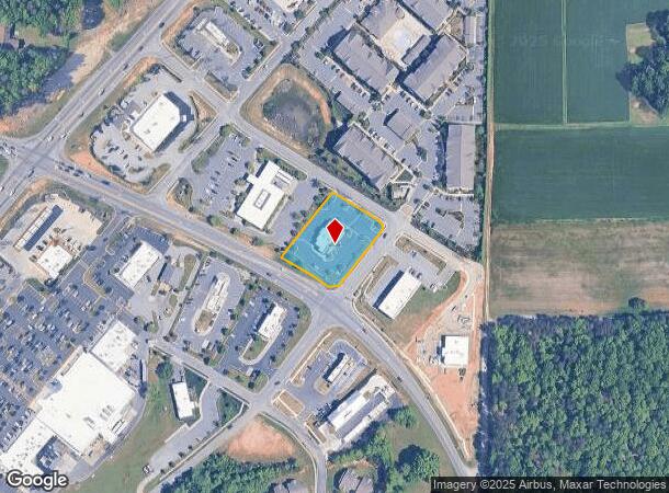
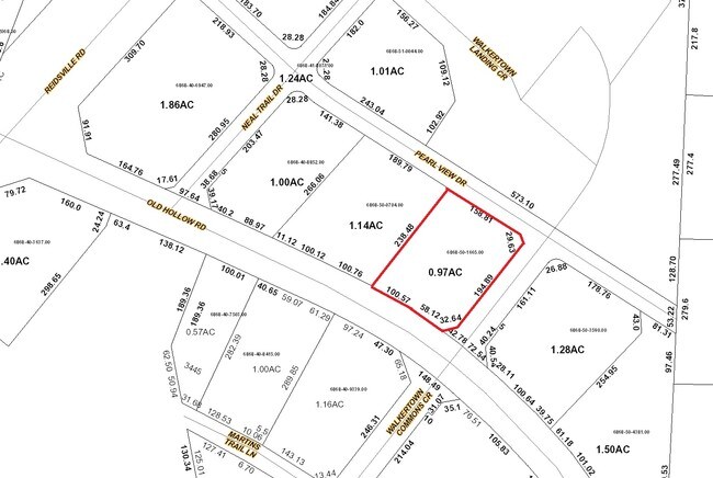
5211 Walkertown Commons Cir
Winston-Salem, NC
Zaxbys
6868-50-1665
ZAXBYS LO:003 BL:5422D BU:1
Storebuilding
Forsyth
X
North Carolina
3710686800J
3
2024
0.97 AC
2025
NE Forsyth County
003103
Greensboro/Winston-Salem
288 SF
DEMOGRAPHICS near 5211 Walkertown Commons Cir
1 Mile
3 Mile
5 Mile
2024 Total Population
2,543
17,612
55,027
2029 Population
2,634
18,292
57,169
Pop Growth 2024-2029
+ 3.58%
+ 3.86%
+ 3.89%
Average Age
41
42
42
2024 Total Households
1,013
6,963
22,344
HH Growth 2024-2029
+ 3.65%
+ 3.86%
+ 3.88%
Median Household Inc
$85,166
$77,655
$67,447
Avg Household Size
2.50
2.50
2.40
2024 Avg HH Vehicles
2.00
2.00
2.00
Median Home Value
$227,722
$229,864
$207,834
Median Year Built
1992
1989
1984
Nearby Places
Map Layers
Map Styles
 Street
 Aerial
- Restaurants
- Banks
- Shops
- Fitness
- Groceries
PUBLIC TRANSPORTATION
AIRPORT
Piedmont Triad International
DRIVE
WALK
Distance
Piedmont Triad International
29 min
16.1 mi
Freight Ports
Virginia Port Authority - Richmond
DRIVE
WALK
Distance
Virginia Port Authority - Richmond
256 min
219.7 mi
SALE & LEASE HISTORY
LISTING DATE
SALE/LEASE

Sep 25, 2016
For Lease
Nearby Properties
Address
Land Use
TOTAL SIZE
Lot Size
Zoning
Address
Land Use
TOTAL SIZE
Lot Size
Zoning
73,908 SF
14.40 AC
GB-S
Address
Land Use
TOTAL SIZE
Lot Size
Zoning
77,879 SF
9.56 AC
GB-S
Address
Land Use
TOTAL SIZE
Lot Size
Zoning
545,857 SF
51.60 AC
GI
Address
Land Use
TOTAL SIZE
Lot Size
Zoning
83,027 SF
14.47 AC
HB-S,LO-S
Address
Land Use
TOTAL SIZE
Lot Size
Zoning
98,617 SF
37.44 AC
RS20
Address
Land Use
TOTAL SIZE
Lot Size
Zoning
77,891 SF
20.91 AC
RS9
Address
Land Use
TOTAL SIZE
Lot Size
Zoning
113,016 SF
6.45 AC
IP
Address
Land Use
TOTAL SIZE
Lot Size
Zoning
11,500 SF
139.75 AC
GI,RS9
Address
Land Use
TOTAL SIZE
Lot Size
Zoning
107,609 SF
11.53 AC
HB-S
Address
Land Use
TOTAL SIZE
Lot Size
Zoning
87,759 SF
253.32 AC
GI,GI-S,RS
Address
Land Use
TOTAL SIZE
Lot Size
Zoning
34,104 SF
7.82 AC
RM12-S
Address
Land Use
TOTAL SIZE
Lot Size
Zoning
39,445 SF
3.49 AC
IP
Address
Land Use
TOTAL SIZE
Lot Size
Zoning
68,106 SF
18.45 AC
IP
Address
Land Use
TOTAL SIZE
Lot Size
Zoning
22,053 SF
5.28 AC
HB-S
Address
Land Use
TOTAL SIZE
Lot Size
Zoning
66,636 SF
14.81 AC
IP
Address
Land Use
TOTAL SIZE
Lot Size
Zoning
41,743 SF
8.51 AC
RM18-S
Address
Land Use
TOTAL SIZE
Lot Size
Zoning
48,400 SF
8.59 AC
HB-S
Address
Land Use
TOTAL SIZE
Lot Size
Zoning
40,714 SF
10.50 AC
IP
Address
Land Use
TOTAL SIZE
Lot Size
Zoning
960 SF
156.19 AC
IP,RS20
Address
Land Use
TOTAL SIZE
Lot Size
Zoning
31,290 SF
9.76 AC
IP,RS9
Address
Land Use
TOTAL SIZE
Lot Size
Zoning
13,101 SF
1.73 AC
HB-S
Address
Land Use
TOTAL SIZE
Lot Size
Zoning
14,424 SF
1.88 AC
HB,LB,RS20
Address
Land Use
TOTAL SIZE
Lot Size
Zoning
18,076 SF
3.60 AC
RS20
Address
Land Use
TOTAL SIZE
Lot Size
Zoning
15,702 SF
2.55 AC
LB-S
Address
Land Use
TOTAL SIZE
Lot Size
Zoning
24,355 SF
11.32 AC
GI
Address
Land Use
TOTAL SIZE
Lot Size
Zoning
30,435 SF
7.04 AC
HB
Address
Land Use
TOTAL SIZE
Lot Size
Zoning
34,540 SF
13.16 AC
IP
Address
Land Use
TOTAL SIZE
Lot Size
Zoning
15,435 SF
3.33 AC
LO-S,PB-S
Address
Land Use
TOTAL SIZE
Lot Size
Zoning
5,663 SF
1.40 AC
HB-S
Address
Land Use
TOTAL SIZE
Lot Size
Zoning
66,377 SF
9.92 AC
GI
The World's #1 Commercial Real Estate Marketplace
Connect with us
© 2026 CoStar Group
The information above has been obtained from sources believed reliable. While we do not doubt its accuracy we have not verified it and make no guarantee, warranty or representation about it. It is your responsibility to independently confirm its accuracy and completeness. Any projections, opinions, assumptions, or estimates used are for example only and do not represent the current or future performance of the property. The value of this transaction to you depends on tax and other factors which should be evaluated by your tax, financial, and legal advisors. You and your advisors should conduct a careful, independent investigation of the property to determine to your satisfaction the suitability of the property for your needs.