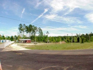
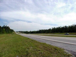
Property Record
34600 State Highway 59, Stapleton, AL 36578

Property Detail
34600 State Highway 59
33-03-05-0-000-003.032
193.9' X 1085'(S) IRR COM AT THE NE COR SEC 5 RUN S 1329.05', TH CONT S 1329.05', TH W 771.16', TH W 102.74', TH S 1060.43' T
Autorepair
Baldwin
AE The base floodplain where base flood elevations are provided. AE Zones are now used on new format FIRMs instead of A1-A30 Zones.
Alabama
2025
4.80 AC
2025
Baldwin County
010400
Mobile
13,555 SF
Daphne-Fairhope-Foley, AL
NEARBY LISTINGS FOR SALE OR LEASE
DEMOGRAPHICS near 34600 State Highway 59
1 mile
3 mile
5 mile
2025 Total Population
693
3,098
9,601
2030 Population
759
3,385
10,475
Pop Growth 2025-2030
+ 9.52%
+ 9.26%
+ 9.10%
Average Age
40
38
36
2025 Total Households
247
1,096
3,439
HH Growth 2025-2030
+ 9.31%
+ 9.40%
+ 9.22%
Median Household Inc
$64,411
$67,068
$75,631
Avg Household Size
2.70
2.70
2.70
2025 Avg HH Vehicles
2.00
2.00
2.00
Median Home Value
$243,137
$260,203
$322,862
Median Year Built
2000
2005
2010
Nearby Places
Map Layers
Map Styles
 Street
 Aerial
Transit
 Traffic
 Biking
Places
Listings with unknown addresses are not visible on the map
- Restaurants
- Banks
- Shops
- Fitness
- Groceries
PUBLIC TRANSPORTATION
AIRPORT
Mobile International
Drive
Walk
Distance
Mobile International
32 min
23.7 mi
Mobile Regional
Drive
Walk
Distance
Mobile Regional
55 min
37.4 mi
Freight Ports
Port of Mobile
Drive
Walk
Distance
Port of Mobile
27 min
20.3 mi
Nearby Properties
Address
Land Use
TOTAL SIZE
Lot Size
Zoning
Address
Land Use
TOTAL SIZE
Lot Size
Zoning
10,300 SF
30 AC
Address
Land Use
TOTAL SIZE
Lot Size
Zoning
73,949 SF
3 AC
Address
Land Use
TOTAL SIZE
Lot Size
Zoning
Address
Land Use
TOTAL SIZE
Lot Size
Zoning
34,347 SF
4.30 AC
Address
Land Use
TOTAL SIZE
Lot Size
Zoning
13,521 SF
9.60 AC
Address
Land Use
TOTAL SIZE
Lot Size
Zoning
23,292 SF
8 AC
Address
Land Use
TOTAL SIZE
Lot Size
Zoning
3,400 SF
4.75 AC
Address
Land Use
TOTAL SIZE
Lot Size
Zoning
1,109 SF
5 AC
Address
Land Use
TOTAL SIZE
Lot Size
Zoning
3,778 SF
1.30 AC
Address
Land Use
TOTAL SIZE
Lot Size
Zoning
10,609 SF
1.60 AC
Address
Land Use
TOTAL SIZE
Lot Size
Zoning
Address
Land Use
TOTAL SIZE
Lot Size
Zoning
2,321 SF
12 AC
Address
Land Use
TOTAL SIZE
Lot Size
Zoning
6,848 SF
2.29 AC
Address
Land Use
TOTAL SIZE
Lot Size
Zoning
10,020 SF
1 AC
Address
Land Use
TOTAL SIZE
Lot Size
Zoning
3,106 SF
1.10 AC
Address
Land Use
TOTAL SIZE
Lot Size
Zoning
9,036 SF
1.10 AC
Address
Land Use
TOTAL SIZE
Lot Size
Zoning
4,550 SF
0.75 AC
Address
Land Use
TOTAL SIZE
Lot Size
Zoning
2,105 SF
10 AC
Address
Land Use
TOTAL SIZE
Lot Size
Zoning
4,822 SF
0.30 AC
Address
Land Use
TOTAL SIZE
Lot Size
Zoning
Address
Land Use
TOTAL SIZE
Lot Size
Zoning
9,019 SF
1 AC
Address
Land Use
TOTAL SIZE
Lot Size
Zoning
4,831 SF
0.75 AC
Address
Land Use
TOTAL SIZE
Lot Size
Zoning
7,200 SF
2.85 AC
Address
Land Use
TOTAL SIZE
Lot Size
Zoning
6,966 SF
5.40 AC
Address
Land Use
TOTAL SIZE
Lot Size
Zoning
2,400 SF
0.68 AC
Address
Land Use
TOTAL SIZE
Lot Size
Zoning
3,629 SF
1.50 AC
Address
Land Use
TOTAL SIZE
Lot Size
Zoning
2,091 SF
3.60 AC
Address
Land Use
TOTAL SIZE
Lot Size
Zoning
8,000 SF
2.82 AC
Address
Land Use
TOTAL SIZE
Lot Size
Zoning
The World's #1 Commercial Real Estate Marketplace
Connect with us
© 2026 CoStar Group
The information above has been obtained from sources believed reliable. While we do not doubt its accuracy we have not verified it and make no guarantee, warranty or representation about it. It is your responsibility to independently confirm its accuracy and completeness. Any projections, opinions, assumptions, or estimates used are for example only and do not represent the current or future performance of the property. The value of this transaction to you depends on tax and other factors which should be evaluated by your tax, financial, and legal advisors. You and your advisors should conduct a careful, independent investigation of the property to determine to your satisfaction the suitability of the property for your needs.