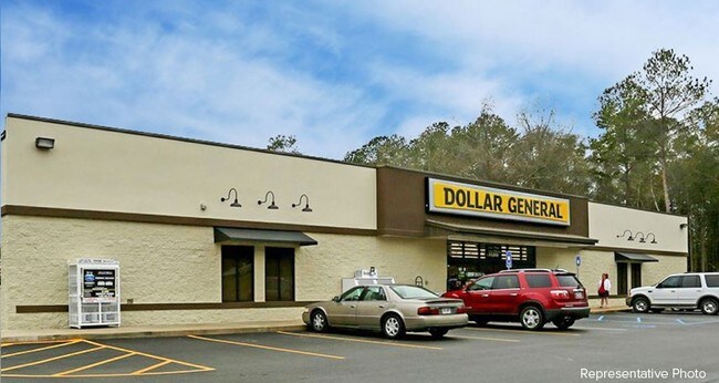
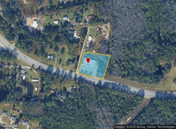
Property Record
3463 Ga Highway 196 W, Hinesville, GA 31313
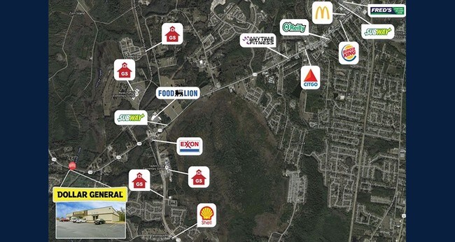
NEARBY LISTINGS FOR SALE OR LEASE
Property Detail
3463 Ga Highway 196 W
030-060
1.89 ACRES 1756 GMD
Commercialnec
Liberty
A
Georgia
13179C0225E
1.94 AC
2024
Liberty County
2024
Savannah
010206
Hinesville, GA
9,230 SF
DEMOGRAPHICS near 3463 Ga Highway 196 W
1 Mile
3 Mile
5 Mile
2024 Total Population
1,763
19,876
44,104
2029 Population
1,916
22,017
48,597
Pop Growth 2024-2029
+ 8.68%
+ 10.77%
+ 10.19%
Average Age
31
32
33
2024 Total Households
570
6,989
16,187
HH Growth 2024-2029
+ 8.60%
+ 10.33%
+ 9.72%
Median Household Inc
$54,912
$53,298
$48,888
Avg Household Size
2.90
2.80
2.70
2024 Avg HH Vehicles
2.00
2.00
2.00
Median Home Value
$149,447
$151,930
$151,565
Median Year Built
1996
1995
1993
Nearby Places
Map Layers
Map Styles
 Street
 Aerial
- Restaurants
- Banks
- Shops
- Fitness
- Groceries
SALE & LEASE HISTORY
LISTING DATE
SALE/LEASE

Sep 24, 2016
For Sale
Nearby Properties
Address
Land Use
TOTAL SIZE
Lot Size
Zoning
Address
Land Use
TOTAL SIZE
Lot Size
Zoning
258,552 SF
41.57 AC
PUD
Address
Land Use
TOTAL SIZE
Lot Size
Zoning
24,288 SF
12.05 AC
PUD
Address
Land Use
TOTAL SIZE
Lot Size
Zoning
11,944 SF
39.41 AC
LI
Address
Land Use
TOTAL SIZE
Lot Size
Zoning
81,366 SF
28.01 AC
R20
Address
Land Use
TOTAL SIZE
Lot Size
Zoning
81,366 SF
35.17 AC
R8
Address
Land Use
TOTAL SIZE
Lot Size
Zoning
71,899 SF
50.12 AC
LI
Address
Land Use
TOTAL SIZE
Lot Size
Zoning
53,103 SF
34.03 AC
I1
Address
Land Use
TOTAL SIZE
Lot Size
Zoning
12,261 SF
10.99 AC
C2
Address
Land Use
TOTAL SIZE
Lot Size
Zoning
13,500 SF
4.90 AC
LI
Address
Land Use
TOTAL SIZE
Lot Size
Zoning
8,520 SF
5.87 AC
C3
Address
Land Use
TOTAL SIZE
Lot Size
Zoning
29,704 SF
3.09 AC
AR1
Address
Land Use
TOTAL SIZE
Lot Size
Zoning
12,000 SF
4.14 AC
AR1
Address
Land Use
TOTAL SIZE
Lot Size
Zoning
46,592 SF
10.49 AC
MFR
Address
Land Use
TOTAL SIZE
Lot Size
Zoning
2,000 SF
69 AC
LI
Address
Land Use
TOTAL SIZE
Lot Size
Zoning
27,129 SF
7.29 AC
LI
Address
Land Use
TOTAL SIZE
Lot Size
Zoning
76.06 AC
LI
Address
Land Use
TOTAL SIZE
Lot Size
Zoning
14,982 SF
2.07 AC
R20
Address
Land Use
TOTAL SIZE
Lot Size
Zoning
115,570 SF
14.60 AC
I1
Address
Land Use
TOTAL SIZE
Lot Size
Zoning
20,600 SF
8.40 AC
C2
Address
Land Use
TOTAL SIZE
Lot Size
Zoning
27.38 AC
MHP/PUD
Address
Land Use
TOTAL SIZE
Lot Size
Zoning
10,000 SF
25 AC
UNZONED RU
Address
Land Use
TOTAL SIZE
Lot Size
Zoning
1,075 SF
4 AC
RA1
Address
Land Use
TOTAL SIZE
Lot Size
Zoning
8,881 SF
11.57 AC
R20
Address
Land Use
TOTAL SIZE
Lot Size
Zoning
14,000 SF
2.12 AC
C2
Address
Land Use
TOTAL SIZE
Lot Size
Zoning
11,356 SF
11.79 AC
OI
Address
Land Use
TOTAL SIZE
Lot Size
Zoning
10,650 SF
1.24 AC
C3
Address
Land Use
TOTAL SIZE
Lot Size
Zoning
4,296 SF
2.51 AC
OI
Address
Land Use
TOTAL SIZE
Lot Size
Zoning
7,996 SF
8 AC
R8
Address
Land Use
TOTAL SIZE
Lot Size
Zoning
10,086 SF
1.01 AC
C2
Address
Land Use
TOTAL SIZE
Lot Size
Zoning
317.62 AC
PUD
The World's #1 Commercial Real Estate Marketplace
Connect with us
© 2025 CoStar Group
The information above has been obtained from sources believed reliable. While we do not doubt its accuracy we have not verified it and make no guarantee, warranty or representation about it. It is your responsibility to independently confirm its accuracy and completeness. Any projections, opinions, assumptions, or estimates used are for example only and do not represent the current or future performance of the property. The value of this transaction to you depends on tax and other factors which should be evaluated by your tax, financial, and legal advisors. You and your advisors should conduct a careful, independent investigation of the property to determine to your satisfaction the suitability of the property for your needs.